
-
Federal
SAFARI 2000 Aerosol Fatty Acid and Stable Isotope Data, Mongu, Dry Season 2000
National Aeronautics and Space Administration —
The Southern African Regional Science Initiative (SAFARI 2000) was conducted in part to investigate the impacts of the large-scale transport and deposition of... -
Federal
SatCORPS CERES GEO Edition 4 Meteosat-7 Full Disk Version 2
National Aeronautics and Space Administration —
CER_GEO_Ed4_MET07_FD_V02 is the Satellite Cloud and Radiation Property retrieval System (SatCORPS) Clouds and the Earth's Radiant Energy System (CERES) Geostationary... -
Federal
SatCORPS CERES GEO Edition 4 GOES-15 Southern Hemisphere Version 1.2
National Aeronautics and Space Administration —
CER_GEO_Ed4_GOE15_SH_V01.2 is the Satellite Cloud and Radiation Property retrieval System (SatCORPS) Clouds and the Earth's Radiant Energy System (CERES)... -
Federal
TEMPO gridded cloud fraction and pressure (O2-O2 dimer) V03 (PROVISIONAL)
National Aeronautics and Space Administration —
O2-O2 cloud Level 3 files provide cloud information on a regular grid covering the TEMPO field of regard for nominal TEMPO observations. Level 3 files are derived by... -
Federal
STAQS NASA G-III GEOstationary Coastal and Air Pollution Events (GEO-CAPE) Airborne Simulator Data
National Aeronautics and Space Administration —
STAQS_AircraftRemoteSensing_NASA-G3_GCAS_Data is the remotely sensed trace gas data for the NASA Gulfstream III aircraft taken by the GEOstationary Coastal and Air... -
Federal
Soil Bulk Density Data (FIFE)
National Aeronautics and Space Administration —
Soil bulk density is defined as the ratio of the mass of dry solids to the bulk volume of the soil occupied by those dry solids. Bulk density of the soil is an... -
Federal
GPM SSMIS on F17 (GPROF) Climate-based Radiometer Precipitation Profiling 1.5 hours 12 km V07 (GPM_2AGPROFF17SSMIS_CLIM) at GES DISC
National Aeronautics and Space Administration —
Version 07 is the current version of the data set. Older versions will no longer be available and have been superseded by Version 07.The 'CLIM' products differ from... -
Federal
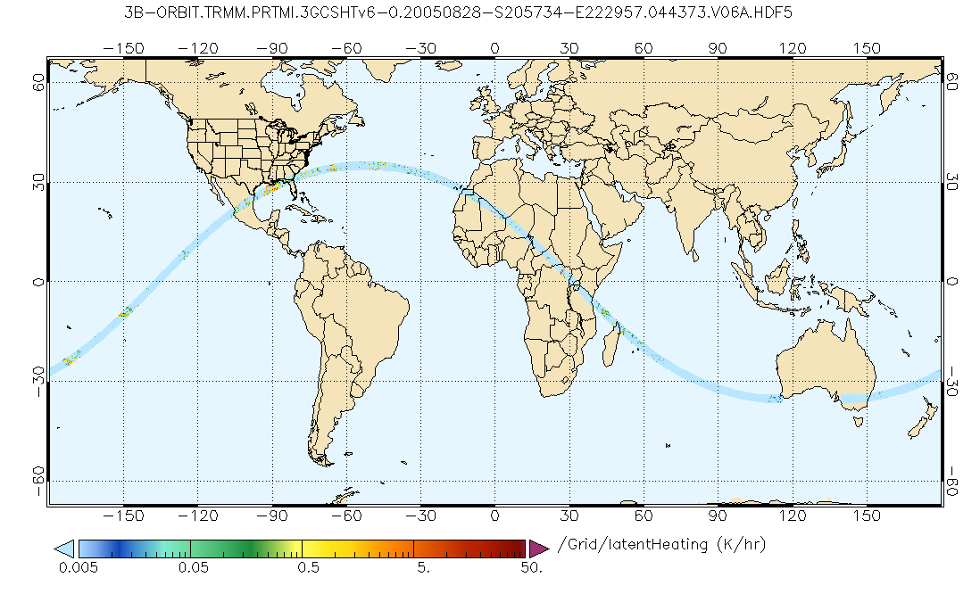
GPM PR and TMI on TRMM Combined Gridded Orbital Convective-Stratiform Latent Heating Profiles L3 1.5 hours 0.25x0.25 degree V07 (GPM_3GCSH_TRMM) at GES DISC
National Aeronautics and Space Administration —
This is the new (GPM-formated) TRMM product. It replaces the old TRMM legacy product TRMM_3G31.Version 07 is the current version of the data set. Older versions will... -
Federal
Annual Summary of Artificial Light At Night from VIIRS/S-NPP at CONUS County and Census Tract V1 (ALAN_VIIRS_CONUS) at GES DISC
National Aeronautics and Space Administration —
This product provides detailed information about the satellite-based data on artificial light at night (ALAN). The Suomi National Polar-orbiting Partnership (S-NPP)... -
Federal
Explorer-7 Thermal Radiation Experiment Selected White Sensor Temperature (Nighttime) Values V001 (EXP7L1TRTWHT) at GES DISC
National Aeronautics and Space Administration —
Explorer-7 Thermal Radiation Experiment Selected White Sensor Temperature (Nighttime) Values product contains the temperatures measured by the white sensor at night.... -
Federal
CERES ERBE-like Instantaneous TOA Estimates Aqua FM3 Edition4
National Aeronautics and Space Administration —
CER_ES8_Aqua-FM3_Edition4 is the Clouds and the Earth's Radiant Energy System (CERES) Earth Radiation Budget Experiment (ERBE)-like Instantaneous Top-of-the-... -
Federal
ABoVE: Lake Growing Season Green Surface Reflectance Trends, AK and Canada, 1984-2019
National Aeronautics and Space Administration —
This dataset provides an annual time series of Landsat green surface reflectance and the derived annual trend during the growing season (June and July) for 472,890... -
Federal
BOREAS TE-18 Landsat TM Maximum Likelihood Classification Image of the SSA
National Aeronautics and Space Administration —
A Landsat-5 TM image from 06-Aug-1990 was used to derive this classification. The objective of this classification is to provide the BOREAS investigators with a data... -
Federal
BOREAS TE-18 Landsat TM Physical Classification Image of the SSA
National Aeronautics and Space Administration —
The objective of this classification is to provide the BOREAS investigators with a data product that characterizes the land cover of the SSA. A Landsat-5 TM image... -
Federal
BOREAS HYD-03 Snow Water Equivalent: 1996
National Aeronautics and Space Administration —
The BOREAS HYD-03 team collected several data sets related to the hydrology of forested areas. This data set contains measurements of snow depth, snow density in 3-cm... -
Federal
SNPP VIIRS High Resolution Level 3 daily aerosol data, 0.1x0.1 degree grid Version 001 (AER_DBDT_D10KM_L3_VIIRS_SNPP) at GES DISC
National Aeronautics and Space Administration —
This High-Resolution (0.1 x 0.1 degree) Level 3 daily Aerosol Optical Depth (AOD) product is generated by combining two Visible Infrared Imaging Radiometer Suite... -
Federal
Calibration Data for Wafer 2 of SRM 3461 - MEMS Cantilever Stiffness
Department of Commerce —
SRM 3461 is an AFM sized chip with an array of seven cantilevers on each chip. The uniformity of the chips offered for sale from wafer 2 is excellent and the SRM... -
Federal
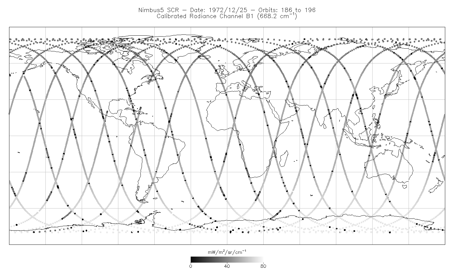
SCR/Nimbus-5 Level 1 Calibrated Radiances V001 (SCRN5L1RAD) at GES DISC
National Aeronautics and Space Administration —
SCRN5L1RAD is the Nimbus-5 Selective Chopper Radiometer (SCR) Level 1 Calibrated Radiances data product. The calibrated radiances are measured at 16 channels from 2.3... -
Federal
FLASHFlux NOAA-20 Daily Gridded TOA and Surfaces/Clouds data Version 1A
National Aeronautics and Space Administration —
FLASH_TISA_NOAA20_Version1A is the Fast Longwave And SHortwave Fluxes (FLASHFlux) Daily Gridded Single Satellite Top-of-Atmosphere (TOA) and Surfaces/Clouds Version...

Official websites use .gov
A
.gov website belongs to an official government
organization in the United States.
Secure .gov websites use HTTPS
A
lock (
) or https:// means you’ve safely connected to
the .gov website. Share sensitive information only on official,
secure websites.