
-
Federal
Dynamics and Chemistry of the Summer Stratosphere Model Output
National Aeronautics and Space Administration —
DCOTSS-Model-Output features numerical model output for the Dynamics and Chemistry of the Summer Stratosphere sub-orbital campaign. Featured in this product are... -
Federal
Earth Radiation Budget Experiment (ERBE) S-10 Wide Field of View (WFOV) Shape Factor (SF) Earth Flux and Albedo
National Aeronautics and Space Administration —
ERBE_S10_WFOV_SF_NAT_1 is the Earth Radiation Budget Experiment (ERBE) S-10 Wide Field of View (WFOV) Shape Factor (SF) Earth Flux and Albedo data product. Data... -
Federal
DSCOVR EPIC Level 2 Sulfur dioxide (SO2) Product with EPIC Version 3 Input Version 2
National Aeronautics and Space Administration —
DSCOVR_EPIC_L2_SO2_v03 is the Deep Space Climate Observatory (DSCOVR) Enhanced Polychromatic Imaging Camera (EPIC) Level 2 Sulfur Dioxide (SO2) product with EPIC... -
Federal
BARREL 3G X-ray Spectrometer (SSPC) Bremsstrahlung X-ray Spectrum Slow Time Resolution, Level 2, 32 s Data
National Aeronautics and Space Administration —
SSPC: 256 channels of slow time resolution, 32 s, Bremsstrahlung X-ray spectra detected with a NaI Scintillator. The nominal energy range covered by the 256 channels... -
Federal
Transcriptional profiling of mammary glands from mice flown on the RRRM-1 mission
National Aeronautics and Space Administration —
In Rodent Research Reference Mission-1 (RRRM-1), also known as RR-8, forty female BALB/cAnNTac mice were flown on the International Space Station. To assess... -
Federal
BARREL 2P Data Processing Unit (HKPG) Analog Housekeeping Voltage, Temperature, Current, and Payload Status, Level 2, 40 s Data
National Aeronautics and Space Administration —
Housekeeping voltage, temperature, current, and payload status values returned every 40 s. NOTE: The analog sensor data in these records are based on the nominal... -
Federal
BARREL 1Q Tri-axial Fluxgate Magnetometer (MAGN) Magnetic Field Data, no Gain Correction, not Despun, Level 2, 0.25 s Data
National Aeronautics and Space Administration —
Three axis DC magnetometer data with nominal conversions applied. Data are neither gain corrected nor despun.The BARREL Mission was a multiple-balloon investigation... -
Federal
GPM TMI on TRMM unpacked data L1A 1.5 hours 13 km V07 (GPM_1ATMI) at GES DISC
National Aeronautics and Space Administration —
This is the new (GPM-formated) TRMM product. It replaces the old TRMM_1A11 Version 07 is the current version of the data set. Previous versions have been superseded... -
Federal
GPM GROUND VALIDATION TOTAL PRECIPITATION SENSOR (HOTPLATE) GCPEX V1
National Aeronautics and Space Administration —
The GPM Ground Validation Total Precipitation Sensor (HotPlate) GCPEx dataset provides a measure of the liquid precipitation rate and accumulation for snow.... -
Federal
GPM GROUND VALIDATION NEXRAD LEVEL II KDMX IFLOODS
National Aeronautics and Space Administration —
The GPM Ground Validation Next Generation Weather Radar (NEXRAD) Level II IFloodS datasets were collected from four sites (see Table 1) from March 29, 2013 to June... -
Federal
GPM GROUND VALIDATION CARE SATELLITE OVERPASS IMAGES GCPEX V1
National Aeronautics and Space Administration —
The GPM Ground Validation CARE Satellite Overpass GCPEx Images are the satellite overpass images for the GPM Cold-season Precipitation Experiment (GCPEx), which... -
Federal
GHRSST Level 2P 1 m Depth Global Sea Surface Temperature from VIIRS on Suomi NPP (GDS2) V1
National Aeronautics and Space Administration —
A global Group for High Resolution Sea Surface Temperature (GHRSST) Level 2P dataset based on retrievals from the Visible Infrared Imaging Radiometer Suite (VIIRS).... -
Federal
NGC 6357/Pismis 24 Chandra Point Source Optical/IR Identifications Catalog
National Aeronautics and Space Administration —
Circumstellar disks are expected to evolve quickly in massive young clusters harboring many OB-type stars. Two processes have been proposed to drive the disk... -
Federal
Spitzer Wide-area InfraRed Extragalactic Survey CDFS MIPS24 Single-Band Catalog
National Aeronautics and Space Administration —
The Spitzer Wide-area InfraRed Extragalactic survey (SWIRE), the largest Spitzer Legacy program, is a wide-area, imaging survey to trace the evolution of dusty, star-... -
Federal
Spitzer-South Pole Telescope Deep Field IRAC 4.5 micron Catalog
National Aeronautics and Space Administration —
The Spitzer-South Pole Telescope Deep Field (SSDF) is a wide-area survey using IRAC to cover 94 square degrees of extragalactic sky, making it the largest IRAC survey... -
Federal
SMUVS Source Catalog
National Aeronautics and Space Administration —
The Spitzer Matching Survey of the Ultra-VISTA Deep Stripes (SMUVS) consists of deep 3.6 and 4.5 imaging of three Ultra-VISTA near-infrared survey stripes in the... -
Federal
EXOSAT TGS Spectra and Lightcurves
National Aeronautics and Space Administration —
Spectra obtained using the EXOSAT transmission grating spectrometer, TGS. There are two databases TGS and TGS2 as follows: * TGS - the grating spectra averaged over... -
Federal
Great Belt research cruise in the Southern Ocean
National Aeronautics and Space Administration —
The Great Belt research cruise investigated the Great Southern Coccolithophore Belt in the Southern Ocean. -
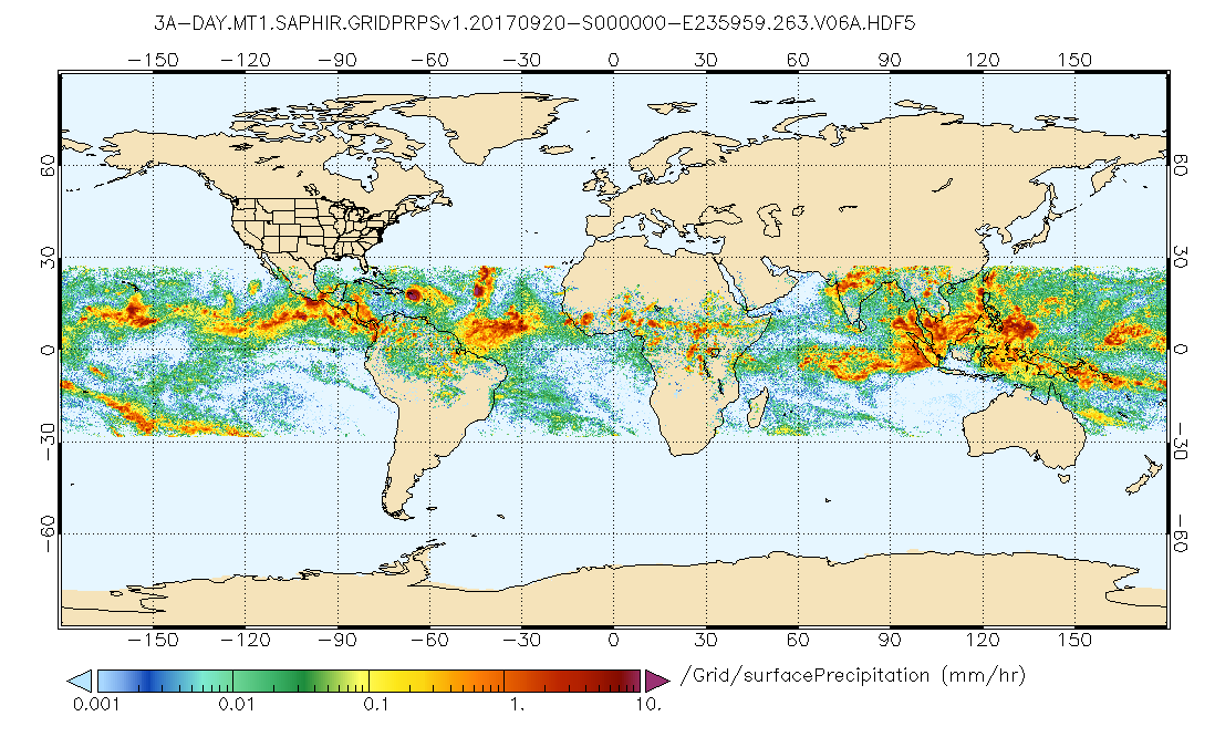
Federal
GPM SAPHIR on MT1 (PRPS) Radiometer Precipitation Profiling L3 1 day 0.25 x 0.25 degree V06 (GPM_3PRPSMT1SAPHIR_DAY) at GES DISC
National Aeronautics and Space Administration —
Version 6 is the current version of this dataset. Older versions are no longer available and have been superseded by Version 6.The Precipitation Retrieval and... -
Federal
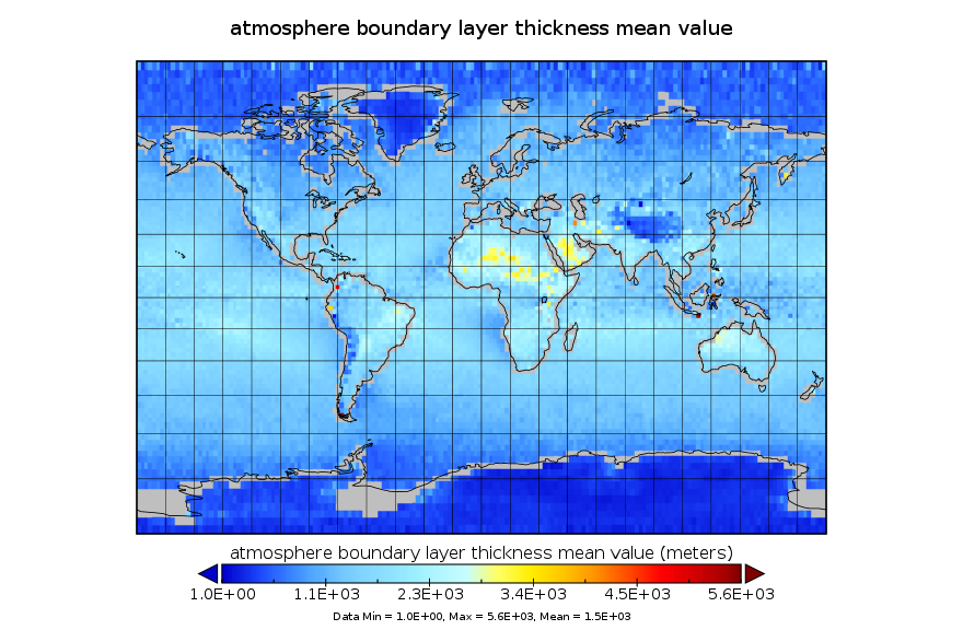
GPS Radio Occultation Boundary Layer Depth Annual L3 V1 (GPSROZPBLA) at GES DISC
National Aeronautics and Space Administration —
This dataset has been superseded by version 2. It provides an annual average of a global planetary boundary layer (PBL) height climatology derived from the...

Official websites use .gov
A
.gov website belongs to an official government
organization in the United States.
Secure .gov websites use HTTPS
A
lock (
) or https:// means you’ve safely connected to
the .gov website. Share sensitive information only on official,
secure websites.