
-
Federal
Timeseries of Arctic-Boreal Lake Area Derived from CubeSat Imagery, 2017
National Aeronautics and Space Administration —
This dataset provides near-daily lake area timeseries for 85,358 lakes across four study areas in Northern Canada and Alaska, USA, between May 1 and October 1, 2017.... -
Federal
Land Cover and Ecosystem Map Collection for Northern Alaska
National Aeronautics and Space Administration —
This data set provides four land cover and ecosystem classification maps for northern Alaska. The maps were produced for several projects and from different data... -
Federal
CMS: LiDAR-derived Canopy Height, Elevation for Sites in Kalimantan, Indonesia, 2014
National Aeronautics and Space Administration —
This dataset provides canopy height and elevation data products derived from airborne LiDAR data collected over 90 sites on the island of Borneo in late 2014. The... -
Federal
Sources of Methane Emissions (Vista-CA), State of California, USA
National Aeronautics and Space Administration —
This dataset provides spatial data products with identified and organized locations of potential methane (CH4) emitting facilities and infrastructure spanning the... -
Federal
NACP Peatland Land Cover Map of Upper Peninsula, Michigan, 2007-2011
National Aeronautics and Space Administration —
This dataset provides a land cover map focused on peatland ecosystems in the upper peninsula of Michigan. The map was produced at 12.5-m resolution using a multi-... -
Federal
ABoVE: SAR-based Methane Ebullition Flux from Lakes, Five Regions, Alaska, 2007-2010
National Aeronautics and Space Administration —
This dataset provides Synthetic Aperture Radar (SAR) estimates of lake-source methane ebullition flux in mg CH4/m2/d for thousands of lakes in five regions across... -
Federal
NACP Soil Organic Matter of Burned Boreal Black Spruce Forests, Alaska, 2009-2011
National Aeronautics and Space Administration —
This data set provides organic soil layer characteristics, estimated carbon content, and soil depth measurements made at four black spruce stands in interior Alaska... -
Federal
Forest Inventories and DBH at Burned and Unburned Forest Sites, Acre, Brazil, 2017
National Aeronautics and Space Administration —
This data set provides measurements of diameter at breast height (DBH) and species identification at four forest sites in the eastern side of Acre, Brazil including... -
Federal
ABoVE: AirSWOT Radar, Orthomosaic, and Water Masks, Yukon Flats Basin, Alaska, 2015
National Aeronautics and Space Administration —
This dataset provides NASA AirSWOT Ka-band (35.75 GHz) radar interferometry data products for water surface elevation (WSE), a derived color-infrared (CIR) digital... -
Federal
Arctic Alaska Vegetation, Geobotanical, Physiographic Maps, 1993-2005
National Aeronautics and Space Administration —
This data set provides the spatial distributions of vegetation types, geobotanical characteristics, and physiographic features for the Arctic tundra region of Alaska... -
Federal
Maps of Vegetation Types and Physiographic Features, Toolik Lake Area, Alaska
National Aeronautics and Space Administration —
This data set provides the spatial distributions of vegetation types, soil carbon, and physiographic features in the Toolik Lake area, Alaska. Specific attributes... -
Federal
ABoVE: Burn Severity, Fire Progression, Landcover and Field Data, NWT, Canada, 2014 NGDA
National Aeronautics and Space Administration —
This data set provides peatland landcover classification maps, fire progression maps, and vegetation community biophysical data collected from areas that were burned... -
Federal
ABoVE: AirSWOT Ka-band Radar over Surface Waters of Alaska and Canada, 2017
National Aeronautics and Space Administration —
AirSWOT is an airborne calibration and validation instrument for the upcoming Surface Water Topography Mission (SWOT) satellite. AirSWOT is capable of producing high... -
Federal
Land Cover and Vegetation Map Collection for Seward Peninsula, Alaska
National Aeronautics and Space Administration —
This data set provides two landcover and vegetation maps for the Seward Peninsula, Alaska. These maps were produced from existing maps, Landsat imagery, and color... -
Federal
Tree Inventory and Biometry Measurements, Tapajos National Forest, Para, Brazil, 2010
National Aeronautics and Space Administration —
This dataset provides tree inventory, tree height, diameter at breast height (DBH), and estimated crown measurements from 30 plots located in the Tapajos National... -
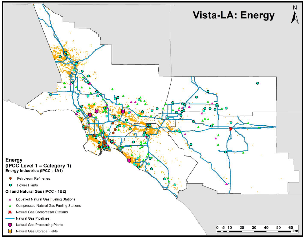
Federal
Sources of Methane Emissions (Vista-LA), South Coast Air Basin, California, USA
National Aeronautics and Space Administration —
This data set provides spatial data products with identified and classified locations of potential methane (CH4) emitting facilities and infrastructure in the South... -
Federal
ABoVE: End of Season Snow Depth at CRREL sites near Fairbanks, Alaska, 2014-2019
National Aeronautics and Space Administration —
This dataset provides 20,582 snow depth measurements collected at six sites near Fairbanks, Alaska, USA. Measurements were made during March or April from 2014-2019.... -
Federal
ABoVE: Burn Severity, Fire Progression, and Field Data, NWT, Canada, 2015-2016 NGDA
National Aeronautics and Space Administration —
This data set provides a fire progression map for year 2015 and measures of burn severity and vegetation community biophysical data collected from areas that were... -
Federal
ABoVE: Gridded 30-m Aboveground Biomass, Shrub Dominance, North Slope, AK, 2007-2016
National Aeronautics and Space Administration —
This dataset includes 30-m gridded estimates of total plant aboveground biomass (AGB), the shrub AGB, and the shrub dominance (shrub/plant AGB) for non-water portions... -
Federal
LiDAR Data, DEM, and Maximum Vegetation Height Product from Southern Idaho, 2014
National Aeronautics and Space Administration —
This dataset provides the point cloud data derived from small footprint waveform LiDAR data collected in August 2014 over Reynolds Creek Experimental Watershed and...

Official websites use .gov
A
.gov website belongs to an official government
organization in the United States.
Secure .gov websites use HTTPS
A
lock (
) or https:// means you’ve safely connected to
the .gov website. Share sensitive information only on official,
secure websites.