ABoVE: SAR-based Methane Ebullition Flux from Lakes, Five Regions, Alaska, 2007-2010
Access & Use Information
Downloads & Resources
-
Google Scholar search resultsHTML
Search results for publications that cite this dataset by its DOI.
-
Download this datasetHTML
This link allows direct data access via Earthdata login
-
View documentation related to this datasetHTML
ORNL DAAC Data Set Documentation
-
This dataset's landing pageHTML
Data set Landing Page DOI URL
-
View documentation related to this datasetKML
ABoVE: SAR-based Methane Ebullition Flux from Lakes, Five Regions, Alaska,...
-
View documentation related to this datasetKML
ABoVE: SAR-based Methane Ebullition Flux from Lakes, Five Regions, Alaska,...
-
View documentation related to this datasetKML
ABoVE: SAR-based Methane Ebullition Flux from Lakes, Five Regions, Alaska,...
-
View documentation related to this datasetKML
ABoVE: SAR-based Methane Ebullition Flux from Lakes, Five Regions, Alaska,...
-
View documentation related to this datasetPDF
ABoVE: SAR-based Methane Ebullition Flux from Lakes, Five Regions, Alaska,...
-
View documentation related to this datasetKML
ABoVE: SAR-based Methane Ebullition Flux from Lakes, Five Regions, Alaska,...
-
Get a related visualizationPNG
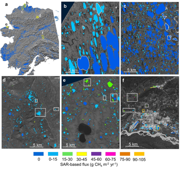
SAR-based lake ebullition maps. Panel A shows Alaska study regions with SAR...
-
The dataset's project home pageHTML
ABoVE project site
-
Landing PageLanding Page
Dates
| Metadata Created Date | December 1, 2022 |
|---|---|
| Metadata Updated Date | December 6, 2023 |
Metadata Source
- Data.json Data.json Metadata
Harvested from NASA Data.json
Graphic Preview

Additional Metadata
| Resource Type | Dataset |
|---|---|
| Metadata Created Date | December 1, 2022 |
| Metadata Updated Date | December 6, 2023 |
| Publisher | ORNL_DAAC |
| Maintainer | |
| Identifier | C2143401901-ORNL_CLOUD |
| Data First Published | 2020-07-15 |
| Language | en-US |
| Data Last Modified | 2023-06-12 |
| Category | ABoVE, geospatial |
| Public Access Level | public |
| Bureau Code | 026:00 |
| Metadata Context | https://project-open-data.cio.gov/v1.1/schema/catalog.jsonld |
| Metadata Catalog ID | https://data.nasa.gov/data.json |
| Schema Version | https://project-open-data.cio.gov/v1.1/schema |
| Catalog Describedby | https://project-open-data.cio.gov/v1.1/schema/catalog.json |
| Citation | Engram, M.J., K.W. Anthony, and F.J. Meyer. 2020. ABoVE: SAR-based Methane Ebullition Flux from Lakes, Five Regions, Alaska, 2007-2010. ORNL DAAC, Oak Ridge, Tennessee, USA. https://doi.org/10.3334/ORNLDAAC/1790 |
| Graphic Preview Description | SAR-based lake ebullition maps. Panel A shows Alaska study regions with SAR footprints outlined in yellow. Subsequent panels show SAR-based CH4 ebullition maps for B) Barrow Peninsula, C) Atqasuk, D) Toolik, E) northern Seward Peninsula, and F) Fairbanks. Study lakes with field-based measurements are outlined (B,C) or boxed (D,E,F) in white. Orange boxes in panel F indicate anthropogenic study lakes. Source: Engram et al. (2020). |
| Graphic Preview File | https://daac.ornl.gov/ABOVE/guides/SAR_Methane_Ebullition_AK_Fig1.png |
| Harvest Object Id | 492cd6a9-4208-4f00-b66b-157c75f7bd75 |
| Harvest Source Id | 58f92550-7a01-4f00-b1b2-8dc953bd598f |
| Harvest Source Title | NASA Data.json |
| Homepage URL | https://doi.org/10.3334/ORNLDAAC/1790 |
| Metadata Type | geospatial |
| Old Spatial | -165.17 64.44 -147.37 71.35 |
| Program Code | 026:001 |
| Source Datajson Identifier | True |
| Source Hash | fa48908359ff9f8e3dfb2c8bd8d9227d885820d66bafe9a9de3ba0295b863dc0 |
| Source Schema Version | 1.1 |
| Spatial | |
| Temporal | 2007-11-13T00:00:00Z/2010-11-11T23:59:59Z |
Didn't find what you're looking for? Suggest a dataset here.

