

78 datasets found for "waste management"
-
State
Surface Water Quality Classifications Set
State of Connecticut —
See full Data Guide here. Surface Water Quality Classifications Set: This dataset is a line and a polygon feature-based layer compiled at 1:24,000 scale that includes... -
Federal
Data from: Soil carbon and nitrogen data during eight years of cover crop and compost treatments in organic vegetable production
Department of Agriculture —
Data presented are on carbon (C) and nitrogen (N) inputs, and changes in soil C and N in eight systems during the first eight years of a tillage-intensive organic... -
Federal
EPA RE-Powering Mapper Large Scale
U.S. Environmental Protection Agency —
The U.S. Environmental Protection Agency (EPA) Office of Land and Emergency Management (OLEM) Office of Communications, Partnerships and Analysis (OCPA) initiated the... -
County
Small Lakes Monitoring
King County, Washington —
Welcome to the Lakes Data and Descriptions application! Use this application to search, view, and download water quality data resulting from volunteer monitoring... -
County
Lake Swimming Beach Bacteria
King County, Washington —
Interactive map of current freshwater swimming beach sampling stations in King County, and downloadable data. -
State
Park Districts
Vermont Center for Geographic Information —
The Parks Districts layer is part of a dataset contains administrative boundaries for Vermont's Agency of Natural Resources. The dataset includes feature classes for... -
Federal
U.S. EPA National Priorities List (NPL) Sites Point Data with CIESIN Modifications, Version 2
National Aeronautics and Space Administration —
The U.S. Environmental Protection Agency (EPA) National Priorities List (NPL) Sites Point Data with CIESIN Modifications, Version 2 is a modified version of the 2014... -
Federal
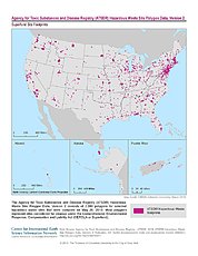
ATSDR Hazardous Waste Site Polygon Data, Version 2
National Aeronautics and Space Administration —
The Agency for Toxic Substances and Disease Registry (ATSDR) Hazardous Waste Site Polygon Data, Version 2 consists of 2,080 polygons for selected hazardous waste... -
Federal
Evaluation and Comparison of Methods for Measuring Ozone and NO2 Concentrations in Ambient Air during DISCOVER-AQ
U.S. Environmental Protection Agency —
NO2 and O3 data from the DISCOVER-AQ field study measured by the United States EPA. This dataset is associated with the following publication: Long, R., M. Beaver, R.... -
Green Infrastructure Practices in the District
District of Columbia —
Stormwater runoff carries harmful pollutants like pet waste, oil, grease, sediment, and litter into the District of Columbia’s waterbodies through storm drains or... -
Federal
Compendium of Environmental Sustainability Indicator Collections: 2006 National Footprint Accounts (NFA)
National Aeronautics and Space Administration —
The 2006 National Footprint Accounts (NFA) portion of the Compendium of Environmental Sustainability Indicator Collections, version 1.1 is a data set that measures... -
State
Connected Sewer Service Areas
State of Connecticut —
This data was created through the modification of an existing sewer service dataset from the CT Office of Policy and Management (OPM), in addition to sewer data from... -
State
Chronic Wasting Disease Sampling Stations - 2025 - CDFW [ds3154]
State of California —
This data is associated with the following layers: Chronic Wasting Disease Sampling Stations - 2023-2024 - CDFW [ds3182]... -
County
Wake County Solid Waste Facilities
Wake County —
Solid Waste Management Division Facilities. This feature layer identifies the type of facility (such as "Recycling Center"), location, hours of operation, who it's... -
State
Chronic Wasting Disease Participating Meat Processors and Taxidermists - 2025 - CDFW [ds3155]
State of California —
This data is associated with the following layers: Chronic Wasting Disease Sampling Stations - 2025 - CDFW [ds3154] (https://apps.wildlife.ca.gov/bios6/?al=3154),... -
State
Solid Waste Management Districts
Vermont Center for Geographic Information —
The Solid waste management districts layer is part of a dataset that contains administrative boundaries for Vermont's Agency of Natural Resources. This dataset... -
State
Surface Water Quality Polygon
State of Connecticut —
See full Data Guide here. Surface Water Quality Classifications Set: This dataset is a line and a polygon feature-based layer compiled at 1:24,000 scale that includes... -
State
Watershed Planning Basins
Vermont Center for Geographic Information —
The Watershed Planning Basin layer is part of a larger dataset contains administrative boundaries for Vermont's Agency of Natural Resources. The dataset includes...
78 datasets found for "waste management"