
-
Federal
Subsurface Characterization and Machine Learning Predictions at Brady Hot Springs Results
Department of Energy —
Geothermal power plants typically show decreasing heat and power production rates over time. Mitigation strategies include optimizing the management of existing wells... -
Federal
NASA Web-Enabled Landsat Data CONUS 30m Composites over Annual Periods V001
National Aeronautics and Space Administration —
WELDUSYR.015 was decommissioned on December 2, 2019. Users are encouraged to use the improved yearly Global Web-Enabled Landsat Data (GWELD) Version 3, 3.1, and 3.2... -
Federal
NASA Web-Enabled Landsat Data Alaska 30m Composites over Monthly Periods V001
National Aeronautics and Space Administration —
WELDAKMO.015 was decommissioned on December 2, 2019. Users are encouraged to use the improved monthly Global Web-Enabled Landsat Data (GWELD) Version 3, 3.1, and 3.2... -
State
Quaternary Geology Line Features
State of Connecticut —
See full Data Guide here. Quaternary Geology Feature Set is 1:24,000-scale data that illustrates the geologic features formed in Connecticut during the Quaternary... -
Federal
University of Illinois Campus Deep Direct-Use Feasibility Study - Thermal Properties of Geologic Formations in Illinois Basin
Department of Energy —
Thermal property data for rocks and and minerals and unconsolidated (glacial) sediments units from within and outside the Illinois Basin were compiled for modeling... -
Federal
SWOT Level 2 Radiometer Brightness Temperatures and Troposphere Operational Data Product, Version 2.0
National Aeronautics and Space Administration —
The SWOT Level 2 Radiometer Brightness Temperatures and Troposphere Operational Geophysical Data Record (OGDR) Version 1.0 dataset produced by the Surface Water and... -
Federal
University of Illinois Campus Deep Direct-Use Feasibility Study - Porosity and Permeability of Rock Formations
Department of Energy —
Porosity and permeability data from published and unpublished sources for the St. Peter and Mt. Simon Sandstones in the Illinois Basin. -
Federal
1988 Spitak Earthquake Database
National Oceanic and Atmospheric Administration, Department of Commerce —
The 1988 Spitak Earthquake database is an extensive collection of geophysical and geological data, maps, charts, images and descriptive text pertaining to the... -
State
Quaternary Geology
State of Connecticut —
See full Data Guide here. Quaternary Geology Feature Set is 1:24,000-scale data that illustrates the geologic features formed in Connecticut during the Quaternary... -
Federal
Interferometric Synthetic Aperture Radar (IFSAR) Alaska
National Aeronautics and Space Administration —
The U.S. Geological Survey (USGS) National Geospatial Program (NGP) developed the Alaska Mapping Initiative (AMI) to collaborate with the State and other Federal... -
Federal
University of Illinois Campus Deep Direct-Use Feasibility Study - Designs for Deep Injection and Monitoring Wells
Department of Energy —
The following information is provided about the design of deeps wells constructed in the Illinois Basin to store, sequester, or dispose of CO2, natural gas, and... -
Federal
SWOT Level 2 Radiometer Brightness Temperatures and Troposphere Interim Data Product Version D
National Aeronautics and Space Administration —
The SWOT Level 2 Radiometer Brightness Temperatures and Troposphere Interim Geophysical Data Record (IGDR) Version D dataset produced by the Surface Water and Ocean... -
Federal
Snake River Plain FORGE: Site Characterization Data
Department of Energy —
The site characterization data used to develop the conceptual geologic model for the Snake River Plain site in Idaho, as part of phase 1 of the Frontier Observatory... -
Federal
2020 NOAA NGS Topobathy Lidar DEM: Anatahan, CNMI
National Oceanic and Atmospheric Administration, Department of Commerce —
Woolpert, Inc. was contracted to acquire and process topographic-bathymetric lidar for the islands of Anatahan, Alamagan, Guguan, and Sarigan in response to Hurricane... -
Federal
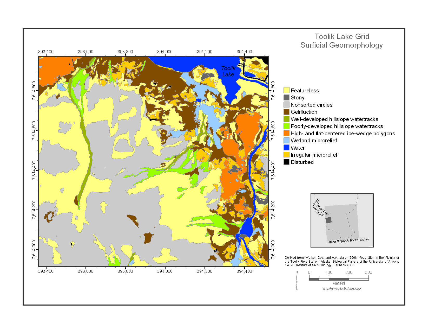
Maps of Vegetation Types and Physiographic Features, Toolik Lake Area, Alaska
National Aeronautics and Space Administration —
This data set provides the spatial distributions of vegetation types, soil carbon, and physiographic features in the Toolik Lake area, Alaska. Specific attributes... -
Federal
SHIFT: HyTES L1 Brightness Temperature, March 23 2022
National Aeronautics and Space Administration —
This dataset holds Level 1 (L1) brightness temperature data collected by the Hyperspectral Thermal Emission Spectrometer (HyTES) instrument. This imagery was acquired... -
Federal
NASA Web-Enabled Landsat Data Alaska 30m Composites over Annual Periods V001
National Aeronautics and Space Administration —
WELDAKYR.015 was decommissioned on December 2, 2019. Users are encouraged to use the improved yearly Global Web-Enabled Landsat Data (GWELD) Version 3, 3.1, and 3.2... -
Federal
NASA Web-Enabled Landsat Data CONUS 30m Composite Pixel Center Lat/Longs V001
National Aeronautics and Space Administration —
WELDUSLL.015 was decommissioned on December 2, 2019. Users are encouraged to use the improved monthly Global Web-Enabled Landsat Data (GWELD) Version 3, 3.1, and 3.2... -
County
1939 Lake County Aerial - SW Quarter
Lake County, Illinois —
This two foot pixel resolution black and white aerial photography was flown on various dates in July and August 1939. They were scanned in 2001, and georeferenced in... -
County
Loudoun Prime Farmland Soils Cluster Option
Loudoun County, Virginia —
See MetadataZOAM-2020-0002, Prime Agricultural Soils and Cluster Subdivision was adopted in June 2024, with an effective date of March 12, 2025, resulted in the...

Official websites use .gov
A
.gov website belongs to an official government
organization in the United States.
Secure .gov websites use HTTPS
A
lock (
) or https:// means you’ve safely connected to
the .gov website. Share sensitive information only on official,
secure websites.