

75 datasets found for "Commuting"
-
City
3.27 Traffic Delay Reduction (dashboard)
City of Tempe —
This operations dashboard shows historic and current data related to this performance measure.The performance measure dashboard is available at 3.27 Traffic Delay... -
Federal
TIGER/Line Shapefile, 2017, nation, U.S., Current NECTA Division National
U.S. Census Bureau, Department of Commerce —
The TIGER/Line shapefiles and related database files (.dbf) are an extract of selected geographic and cartographic information from the U.S. Census Bureau's Master... -
City
3.27 Traffic Delay Reduction
City of Tempe —
This page provides information for the Traffic Delay Reduction performance measure. -
Federal
2016 Cartographic Boundary File, Current Metropolitan/Micropolitan Statistical Area for United States, 1:5,000,000
U.S. Census Bureau, Department of Commerce —
The 2016 cartographic boundary shapefiles are simplified representations of selected geographic areas from the U.S. Census Bureau's Master Address File /... -
State
MD iMAP: Maryland Transit - MTA Bus Stops
State of Maryland —
This is a MD iMAP hosted service layer. Find more information at http://imap.maryland.gov. Maryland Tranist Administration Transit Stops and Stations including Local... -
Federal
TIGER/Line Shapefile, 2019, nation, U.S., Current NECTA Division National
U.S. Census Bureau, Department of Commerce —
The TIGER/Line shapefiles and related database files (.dbf) are an extract of selected geographic and cartographic information from the U.S. Census Bureau's Master... -
Federal
Collection Series Information for the 2019 Cartographic Boundary File KML, Current Metropolitan/Micropolitan Statistical Area for United States
U.S. Census Bureau, Department of Commerce —
The 2019 cartographic boundary KMLs are simplified representations of selected geographic areas from the U.S. Census Bureau's Master Address File / Topologically... -
Metro Station Entrances Regional
District of Columbia —
Metro Station Entrances (regional). This dataset contains points representing Metro facilities, created as part of the DC Geographic Information System (DC GIS) for... -
Federal
TIGER/Line Shapefile, 2016, nation, U.S., Current Metropolitan Division National
U.S. Census Bureau, Department of Commerce —
The TIGER/Line shapefiles and related database files (.dbf) are an extract of selected geographic and cartographic information from the U.S. Census Bureau's Master... -
Carpooling Slug Locations
District of Columbia —
This layer shows slugging locations (pick-up and drop-off points) for casual carpooling. The data was originally obtained from Sluglines.com. -
State
MD iMAP: Maryland Transit - MARC Train Lines
State of Maryland —
This is a MD iMAP hosted service layer. Find more information at http://imap.maryland.gov. Maryland Transit Administration MARC Commuter Rail lines. For more... -
County
Transit Bus App
Loudoun County, Virginia —
Transit is a mobile app packed with features that helps you plan a trip on Loudoun County Transit buses. Real time bus tracking and information, service alerts and... -
Federal
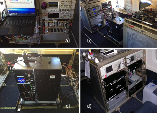
ASCENDS: Airborne CO2 LAS Retrieval, Indianapolis, IN, USA, 2014
National Aeronautics and Space Administration —
This dataset provides in situ airborne measurements of atmospheric carbon dioxide (CO2) over Indianapolis, Indiana (IN) on September 3, 2014 during the morning... -
County
Park & Ride Lookup
Loudoun County, Virginia —
Park and Ride interactive map. Identify the location of each park and ride lot in relation to any street address within Loudoun County.Park and Ride Lot Locations and... -
City
Seattle Transportation Plan Transit Element
City of Seattle —
Frequent, reliable transit service is the foundation of a transportation system that empowers all travelers and makes Seattle a truly transit-friendly city. A robust... -
ACS Economic Characteristics DC Experimental
District of Columbia —
Experimental Employment, Commuting, Occupation, Income, Health Insurance, Poverty variables Due to the impact of the COVID-19 pandemic, instead of providing the... -
Commuter Bus Stops
District of Columbia —
Commuter bus stops in the District of Columbia. -
Maryland Area Regional Commuter Routes
District of Columbia —
Maryland Transit Routes -
ACS 5-Year Economic Characteristics DC Census Tract
District of Columbia —
Employment, Commuting, Occupation, Income, Health Insurance, Poverty, and more. This service is updated annually with American Community Survey (ACS) 5-year data.... -
Federal
Collection Series Information for the 2019 Cartographic Boundary File Shapefile, Current Metropolitan/Micropolitan Statistical Area for United States
U.S. Census Bureau, Department of Commerce —
The 2019 cartographic boundary shapefiles are simplified representations of selected geographic areas from the U.S. Census Bureau's Master Address File /...
75 datasets found for "Commuting"