
-
Federal
2013 Early Life History Experiment Data - Snake River sockeye salmon captive propagation
National Oceanic and Atmospheric Administration, Department of Commerce —
In the early 1990s, Redfish Lake sockeye salmon from the Sawtooth Basin in Idaho were on the brink of extinction, and they were listed as endangered under the US... -
Federal
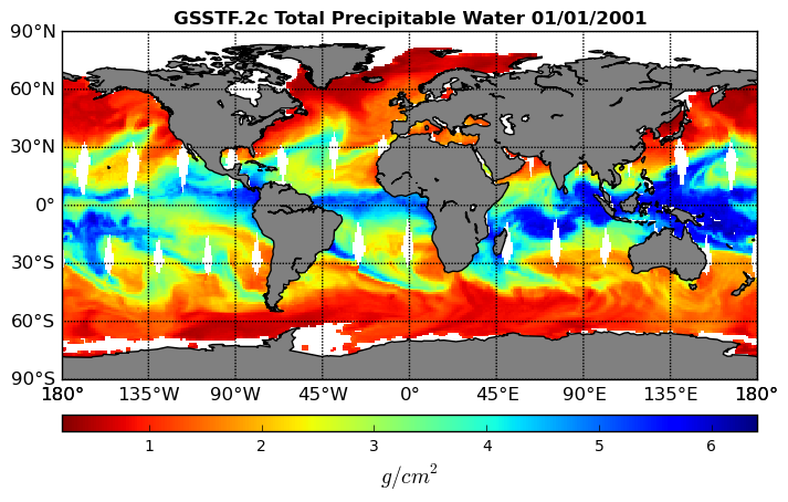
Goddard Satellite-Based Surface Turbulent Fluxes, 1x1 deg Daily Grid, Set1 V2c (GSSTF) at GES DISC
National Aeronautics and Space Administration —
These data are the Goddard Satellite-based Surface Turbulent Fluxes Version-2c (GSSTF2c) Dataset recently produced through a MEaSUREs funded project led by Dr. Chung-... -
Federal
FLUXNET Marconi Conference Gap-Filled Flux and Meteorology Data, 1992-2000
National Aeronautics and Space Administration —
Fluxes of carbon dioxide, water vapor, and energy exchange have been measured at 38 forest, grassland, and crop sites as part of the EUROFLUX and AmeriFlux projects.... -
Federal
Nimbus-7 Narrow Field of View (NFOV) Maximum Likelihood Cloud Estimation (MLCE) Data in Native Format
National Aeronautics and Space Administration —
NIMBUS7_NFOV_MLCE data are Nimbus 7 Narrow Field of View (NFOV) Maximum Likelihood Cloud Estimation (MLCE) Data in Native Format.The NIMBUS7_NFOV_MLCE data set uses... -
Federal
CERES MODIS Cloud Retrievals in ISCCP-D2like Format Day Terra FM2 Edition3A NGDA
National Aeronautics and Space Administration —
CER_ISCCP-D2like-Day_Terra-FM2-MODIS_Edition3A is the Clouds and the Earth's Radiant Energy System (CERES) Moderate Resolution Imaging Spectroradiometer (MODIS) Cloud... -
Federal
CERES MODIS Cloud Retrievals in ISCCP-D2like Format Nighttime Aqua FM4 Edition3A NGDA
National Aeronautics and Space Administration —
CER_ISCCP-D2like-Nit_Aqua-FM4-MODIS_Edition3A is the Clouds and the Earth's Radiant Energy System (CERES) Moderate Resolution Imaging Spectroradiometer (MODIS) Cloud... -
Federal
Fast Longwave And SHortwave Fluxes (FLASHflux) Clouds and Radiative Swath (SSF) TERRA-FM1 data in HDF Version 4A
National Aeronautics and Space Administration —
FLASH_SSF_Terra-FM1-MODIS_Version4A is the Fast Longwave And Shortwave Radiative Fluxes (FLASHFlux) Clouds and Radiative Swath (SSF) TERRA-FM1 data in HDF Version 4A... -
Federal
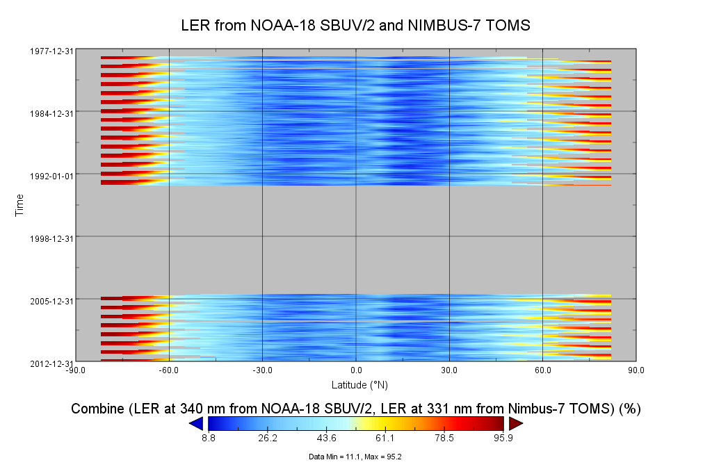
Multi-Satellite Lambertian Equivalent Reflectivity (Local Satellite Time) 1 day L3 Global 5.0deg Lat Zones V1 (MSLERLSTL3zm) at GES DISC
National Aeronautics and Space Administration —
The Multi-Satellite Lambertian Equivalent Reflectivity (Local Satellite Time) 1 day L3 Global 5.0deg Lat Zones data product (MSLERLSTL3zm) is derived from... -
Federal
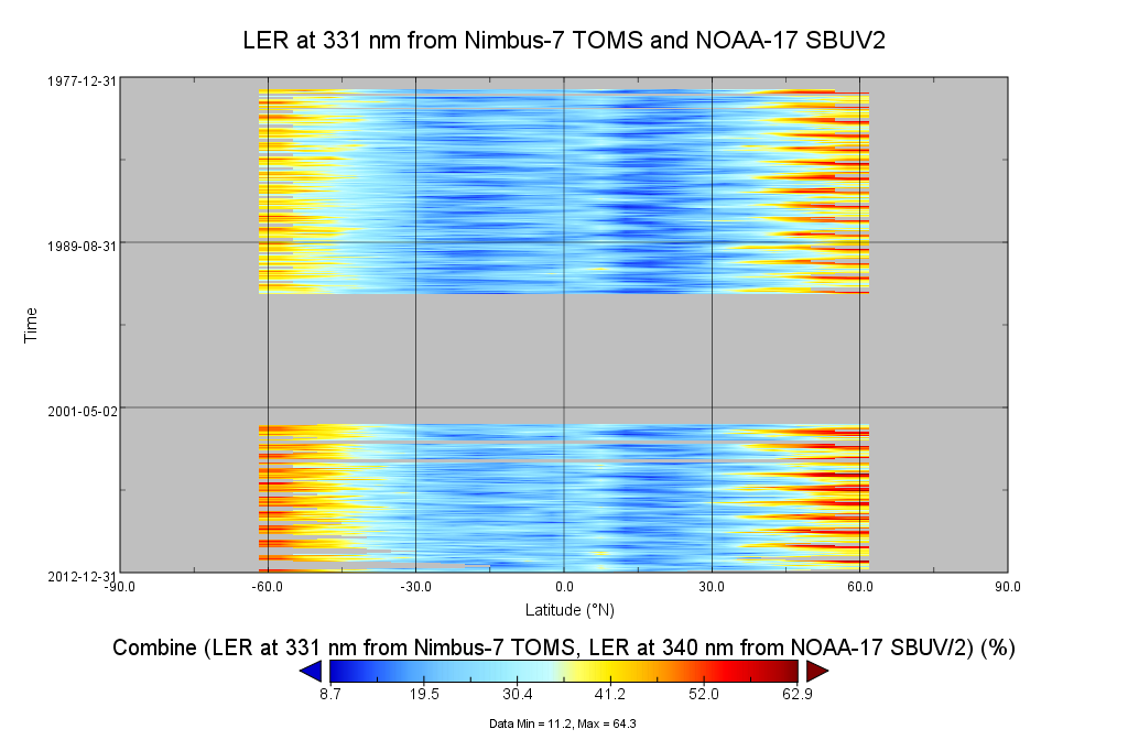
Multi-Satellite Lambertian Equivalent Reflectivity (Local Satellite Time) 10-Day L3 Global 2.0x5.0deg Lat/Lon Grid V1 (MSLERLSTL3d10) at GES DISC
National Aeronautics and Space Administration —
The Multi-Satellite Lambertian Equivalent Reflectivity (Local Satellite Time) 10-Day L3 Global 2.0x5.0deg Lat/Lon Grid data product is derived from multi-satellite... -
Federal
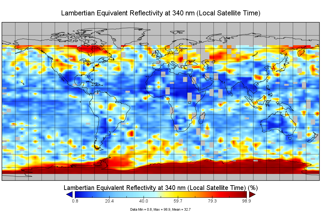
Multi-Satellite Lambertian Equivalent Reflectivity (Noon Normalized) 1 day L3 Global 5.0deg Lat Zones V1 (MSLERNNL3zm) at GES DISC
National Aeronautics and Space Administration —
The Multi-Satellite Lambertian Equivalent Reflectivity (Noon Normalized) 1 day L3 Global 5.0deg Lat Zones data product (MSLERNNL3zm) is derived from observations made... -
Federal
Social Behavior - Snake River sockeye salmon captive propagation
National Oceanic and Atmospheric Administration, Department of Commerce —
In the early 1990s, Redfish Lake sockeye salmon from the Sawtooth Basin in Idaho were on the brink of extinction, and they were listed as endangered under the US... -
Federal
BSEE Data Center - Paleontologic Information
Department of the Interior —
Paleontologic Information and Data includes publicly releasable biostratigraphic and paleobathymetric summary information on active and expired fields and leases in... -
Federal
CERES Bidirectional Scans Aqua FM3 Edition1-CV
National Aeronautics and Space Administration —
CER_BDS_Aqua-FM3_Edition1-CV is the Clouds and the Earth's Radiant Energy System (CERES) Bidirectional Scans (BDS) Aqua Flight Model 3 (FM3) Edition1-CV data... -
Federal
ASTER Registered Radiance at the Sensor - Orthorectified V003
National Aeronautics and Space Administration —
The Terra Advanced Spaceborne Thermal Emission and Reflection Radiometer (ASTER) Orthorectified Registered Radiance at the Sensor (AST14OTH) products contain imagery... -
Federal
Snake River Plain Play Fairway Analysis: Phase 1 Report
Department of Energy —
This presents the results of Phase 1 of the Snake River Plain Play Fairway Analysis project, along with a proposed work for Phase 2. No new data were collected, but... -
Federal
Lidar Atmospheric Sensing Experiment (LASE) Validation
National Aeronautics and Space Administration —
An extensive validation experiment was conducted in September 1995 from Wallops Island, Virginia, to evaluate the performance of the LASE (Lidar Atmospheric Sensing... -
Federal
MODIS/Terra+Aqua Vegetation Index from MAIAC, Daily L3 Global 0.05Deg CMG V061
National Aeronautics and Space Administration —
The MCD19A3CMG Version 6.1 data product is a Moderate Resolution Imaging Spectroradiometer (MODIS) Terra and Aqua combined Multi-Angle Implementation of Atmospheric... -
Federal
Multi-Satellite Lambertian Equivalent Reflectivity (Noon Normalized) 10-Day L3 Global 2.0x5.0deg Lat/Lon Grid V1 (MSLERNNL3d10) at GES DISC
National Aeronautics and Space Administration —
The Multi-Satellite Lambertian Equivalent Reflectivity (Noon Normalized) 10-Day L3 Global 2.0x5.0deg Lat/Lon Grid data product is derived from multi-satellite Solar... -
Federal
CERES and GEO-Enhanced TOA, Within-Atmosphere and Surface Fluxes, Clouds and Aerosols 3-Hourly Terra-Aqua Edition4A NGDA
National Aeronautics and Space Administration —
CER_SYN1deg-3Hour_Terra-Aqua-MODIS_Edition4A is the Clouds and the Earth's Radiant Energy System (CERES) and geostationary (GEO)-Enhanced Top of Atmosphere (TOA),...

Official websites use .gov
A
.gov website belongs to an official government
organization in the United States.
Secure .gov websites use HTTPS
A
lock (
) or https:// means you’ve safely connected to
the .gov website. Share sensitive information only on official,
secure websites.