
-
Federal
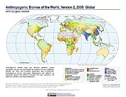
Anthropogenic Biomes of the World, Version 2: 2000
National Aeronautics and Space Administration —
The Anthropogenic Biomes of the World, Version 2: 2000 data set describes anthropogenic transformations within the terrestrial biosphere caused by sustained direct... -
Federal
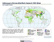
Anthropogenic Biomes of the World, Version 2: 1700
National Aeronautics and Space Administration —
The Anthropogenic Biomes of the World, Version 2: 1700 data set describes anthropogenic transformations within the terrestrial biosphere caused by sustained direct... -
Federal
2012 Environmental Performance Index and Pilot Trend Environmental Performance Index
National Aeronautics and Space Administration —
The 2012 Environmental Performance Index (EPI) ranks 132 countries on 22 performance indicators in the following 10 policy categories: environmental burden of... -
Federal
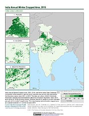
India Annual Winter Cropped Area, 2001-2016 NGDA
National Aeronautics and Space Administration —
The India Annual Winter Cropped Area, 2001 - 2016 consists of annual winter cropped areas for most of India (except the Northeastern states) from 2000-2001 to... -
Federal
Effects of Climate Change on Global Food Production from SRES Emissions and Socioeconomic Scenarios
National Aeronautics and Space Administration —
The Effects of Climate Change on Global Food Production from SRES Emissions and Socioeconomic Scenarios is an update to a major crop modeling study by the NASA... -
Federal
IPCC Socio-Economic Baseline Dataset
National Aeronautics and Space Administration —
The Intergovernmental Panel on Climate Change (IPCC) Socio-Economic Baseline Dataset consists of population, human development, economic, water resources, land cover,... -
Federal
Global Agricultural Lands: Croplands, 2000
National Aeronautics and Space Administration —
The Global Croplands data set represents the proportion of land areas used as cropland (land used for the cultivation of food) in the year 2000. Satellite data from... -
Federal
2008 Environmental Performance Index (EPI)
National Aeronautics and Space Administration —
The 2008 Environmental Performance Index (EPI) centers on two broad environmental protection objectives: (1) reducing environmental stresses on human health, and (2)... -
Federal
Anthropogenic Biomes of the World, Version 2: 1800
National Aeronautics and Space Administration —
The Anthropogenic Biomes of the World, Version 2: 1800 data set describes anthropogenic transformations within the terrestrial biosphere caused by sustained direct... -
Federal
China Dimensions Data Collection: Agricultural Statistics of the People's Republic of China: 1949-1990
National Aeronautics and Space Administration —
The Agricultural Statistics of the People's Republic of China, 1949-1990 is an historical collection of agricultural statistical data compiled by China's State... -
Federal
China Dimensions Data Collection: Priority Programme for China's Agenda 21
National Aeronautics and Space Administration —
The Priority Programme for China's Agenda 21 consists of full-text program descriptions supporting China's economic and social development. The descriptions represent... -
Federal
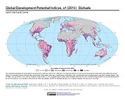
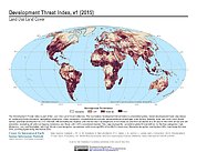
Development Threat Index
National Aeronautics and Space Administration —
The Development Threat Index data set is a terrestrial global, future development threat map based on combining these resources: agricultural expansion, urban... -
Federal
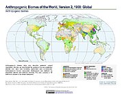
Anthropogenic Biomes of the World, Version 2: 1900
National Aeronautics and Space Administration —
The Anthropogenic Biomes of the World, Version 2: 1900 data set describes anthropogenic transformations within the terrestrial biosphere caused by sustained direct... -
Federal
Millennium Ecosystem Assessment: MA Rapid Land Cover Change
National Aeronautics and Space Administration —
The Millennium Ecosystem Assessment: MA Rapid Land Cover Change provides data and information on global and regional land cover change in raster format for... -
Federal
Global Fire Emissions Indicators, Grids: 1997-2015
National Aeronautics and Space Administration —
The Global Fire Emissions Indicators, Grids: 1997-2015 contain a time-series of rasters from 1997 to 2015 for total area burned (hectares) and total carbon content... -
Federal
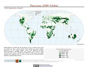
Global Agricultural Lands: Pastures, 2000
National Aeronautics and Space Administration —
The Global Pastures data set represents the proportion of land areas used as pasture land (land used to support grazing animals) in the year 2000. Satellite data from...

Official websites use .gov
A
.gov website belongs to an official government
organization in the United States.
Secure .gov websites use HTTPS
A
lock (
) or https:// means you’ve safely connected to
the .gov website. Share sensitive information only on official,
secure websites.