
-
Federal
ABoVE: Peak Greenness for Canadian Boreal Forest from Landsat 5 TM Imagery, 1984-2011 recent views
National Aeronautics and Space Administration —
This dataset provides a 28-year time series of peak greenness (NDVI) data derived from Landsat 5 TM imagery over the boreal forest region of Canada. Landsat 5 TM... -
Federal
BOREAS TE-18 Landsat TM Maximum Likelihood Classification Image of the SSA recent views
National Aeronautics and Space Administration —
A Landsat-5 TM image from 06-Aug-1990 was used to derive this classification, the objective of which is to provide BOREAS investigators with a data product that... -
Federal
ABoVE: Active Layer Soil Characterization of Permafrost Sites, Northern Alaska, 2018 recent views
National Aeronautics and Space Administration —
This dataset provides in situ soil measurements including soil dielectric properties, temperature, and moisture profiles, active layer thickness (ALT), and... -
Federal
LBA-ECO LC-22 Land Cover from MODIS Vegetation Indices, Mato Grosso, Brazil NGDA recent views
National Aeronautics and Space Administration —
This data set, LBA-ECO LC-22 Land Cover from MODIS Vegetation Indices, Mato Grosso, Brazil, provides land cover classifications for Mato Grosso, Brazil, for the years... -
Federal
SAFARI 2000 Historical Fire Maps, Kruger National Park, 1992-2001 recent views
National Aeronautics and Space Administration —
Kruger National Park (KNP) was established in 1898 to protect wildlife on nearly 2 million hectares of the South African Lowveld. Savanna fires are common in the... -
Federal
VEMAP 2: U.S. Monthly Climate, 1895-1993, Version 2 recent views
National Aeronautics and Space Administration —
An integrated input data set for ecosystem and vegetation modeling for the conterminous United States. The data set is a ~100 year gridded monthly time series of... -
Federal
VEMAP 1: U.S. Soil recent views
National Aeronautics and Space Administration —
An integrated input data set for ecosystem and vegetation modeling for the conterminous United States: Soil -
Federal
VEMAP 2: Monthly Historical and Future Climate Data, Alaska, USA recent views
National Aeronautics and Space Administration —
This data set provides the results of the development of The Vegetation/Ecosystem Modeling and Analysis Project (VEMAP) Phase 2 transient climate change scenarios for... -
Federal
VEMAP 2: U.S. Monthly Climate Change Scenarios, Version 2 recent views
National Aeronautics and Space Administration —
Data sets of transient climate change scenarios based on coupled atmosphere-ocean general circulation model (AOGCM) transient climate experiments with transient... -
Federal
BOREAS HYD-04 Standard Snow Course Data recent views
National Aeronautics and Space Administration —
Contains the standard snow course data collected at various sites in the NSA and SSA by HYD-04. -
Federal
Remote Sensing Data Before and After California Rim and King Forest Fires, 2010-2015 recent views
National Aeronautics and Space Administration —
This data set provides high-resolution surface reflectance, thermal imagery, burn severity metrics, and LiDAR-derived structural measures of forested areas in the... -
Federal
Tree Inventory and Biometry Measurements, Tapajos National Forest, Para, Brazil, 2010 recent views
National Aeronautics and Space Administration —
This dataset provides tree inventory, tree height, diameter at breast height (DBH), and estimated crown measurements from 30 plots located in the Tapajos National... -
Federal
BOREAS TGB-06 Soil Methane Oxidation and Production from NSA BP and Fen Sites recent views
National Aeronautics and Space Administration —
Contains 1993, 1994, and 1996 methane concentrations from TGB-06 in the NSA and SSA. -
Federal
Tree Canopy Cover for the Circumpolar Taiga-Tundra Ecotone: 2000-2005 NGDA recent views
National Aeronautics and Space Administration —
This data set provides a map of selected areas with defined tree canopy cover over the circumpolar taiga-tundra ecotone (TTE). Canopy cover was derived from the... -
Federal
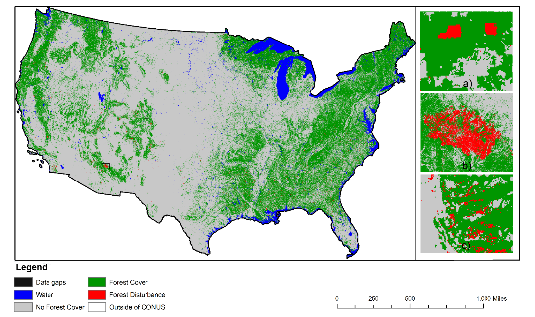
NACP NAFD Project: Forest Disturbance History from Landsat, 1986-2010 recent views
National Aeronautics and Space Administration —
The North American Forest Dynamics (NAFD) products provided in this data set consist of 25 annual and two time-integrated forest disturbance maps for the conterminous... -
Federal
Burned and Unburned Field Site Data, Noatak, Seward, and North Slope, AK, 2016-2018 recent views
National Aeronautics and Space Administration —
This dataset includes field measurements from unburned and burned 10 m x 10 m and 1 m x 1 m plots in the Noatak, Seward, and North Slope regions of the Alaskan tundra... -
Federal
MASTER: HyspIRI Airborne Campaign, California, Spring 2015 recent views
National Aeronautics and Space Administration —
This dataset includes Level 1B (L1B) and Level 2 (L2) data products from the MODIS/ASTER Airborne Simulator (MASTER) instrument. The spectral data were collected as... -
Federal
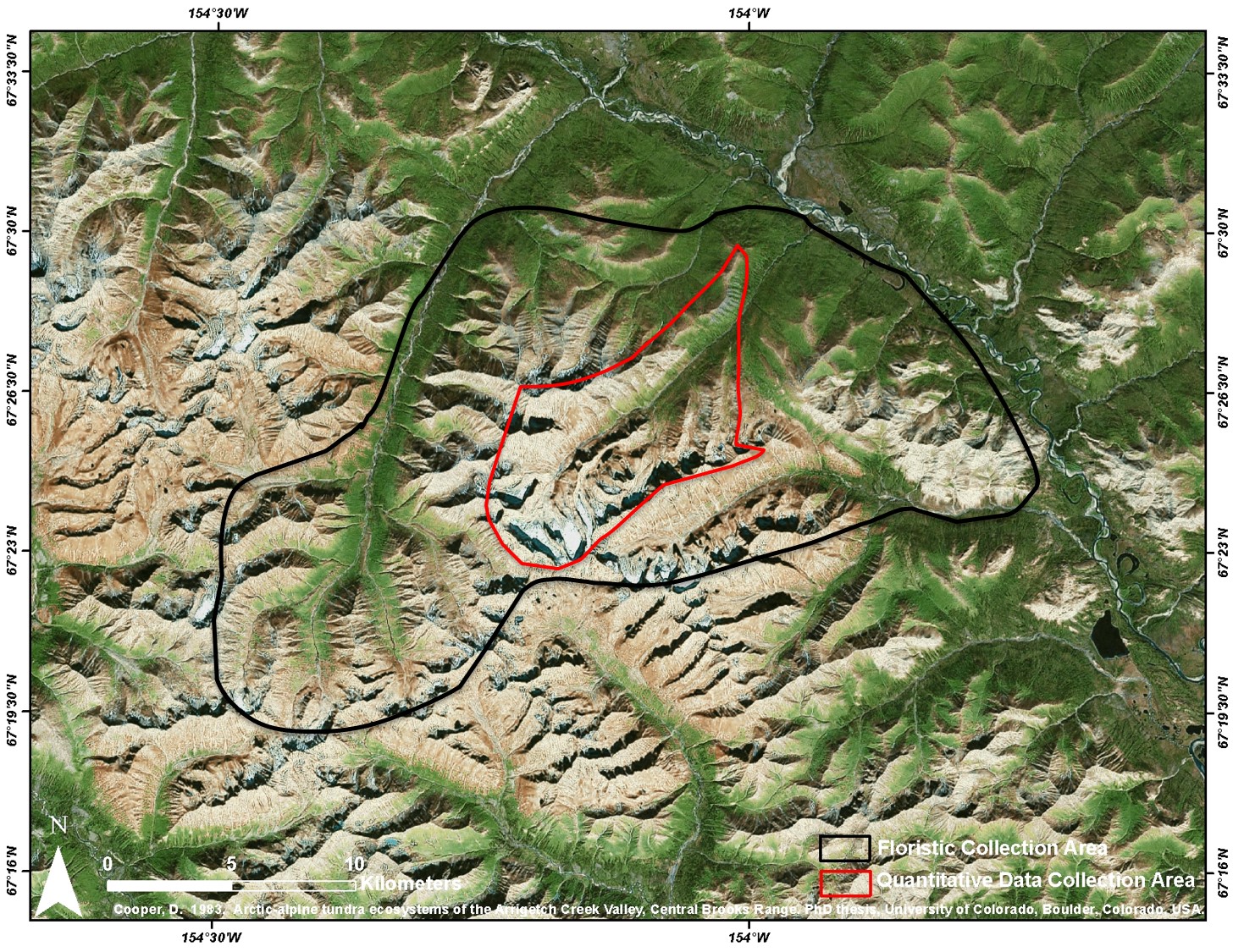
Arctic Vegetation Plots at Arrigetch Peaks, Alaska, 1978-1981 recent views
National Aeronautics and Space Administration —
This data set provides environmental and vegetation data collected between 1978 and 1981 from 439 study plots at Arrigetch Peaks research site, located in the Gates... -
Federal
Arctic Vegetation Plots, Prudhoe Bay ArcSEES Road Study, Lake Colleen, Alaska, 2014 recent views
National Aeronautics and Space Administration —
This dataset provides environmental, soil, and vegetation data collected from study plots in the vicinity of Lake Colleen off the Spine Road at Prudhoe Bay, Alaska,... -
Federal
Delta-X: UAVSAR L1 Single Look Complex (SLC) Stack Products, MRD, Louisiana, 2021 recent views
National Aeronautics and Space Administration —
This dataset contains UAVSAR Level 1 (L1) Single Look Complex (SLC) stack products for Delta-X flight lines acquired during 2021-03-27 to 2021-04-18 (spring) and...

Official websites use .gov
A
.gov website belongs to an official government
organization in the United States.
Secure .gov websites use HTTPS
A
lock (
) or https:// means you’ve safely connected to
the .gov website. Share sensitive information only on official,
secure websites.