
-
Federal
TIGER/Line Shapefile, Current, County, Grant County, NM, Address Range-Feature Name Relationship File
U.S. Census Bureau, Department of Commerce —
The TIGER/Line shapefiles and related database files (.dbf) are an extract of selected geographic and cartographic information from the U.S. Census Bureau's Master... -
Federal
Observation-well drawdown data from the 16 multiple-well aquifer tests conducted in Pahute Mesa, Nevada National Security Site, 2009–14
Department of the Interior —
This USGS data release represents tabular data and water-level modeling files for the 16 Pahute Mesa multiple-well aquifer tests conducted from 2009–2014. This... -
Federal
Seepage-run discharge measurements, June 7, 2022, Ukumehame Gulch, Maui, Hawai'i
Department of the Interior —
This data release contains a comma-delimited ascii file of ten same-day, discrete discharge measurements made at sites along selected reaches of Ukumehame Gulch,... -
Federal
Geochemical, mineralogical, and grain-size data for in-situ solid materials and suspended sediment at Malakoff Diggins State Historic Park, Nevada County, California
Department of the Interior —
This dataset includes data for in-situ solid materials and suspended sediments from surface-water samples, as well as surface-water chemistry from samples collected... -
Federal
TIGER/Line Shapefile, 2024, County, Wayne County, IN, Area Hydrography
U.S. Census Bureau, Department of Commerce —
The TIGER/Line shapefiles and related database files (.dbf) are an extract of selected geographic and cartographic information from the U.S. Census Bureau's Master... -
Federal
On the implications of aerosol liquid water and phase separation for organic aerosol mass
U.S. Environmental Protection Agency —
This dataset contains data presented in the figures of the paper "On the implications of aerosol liquid water and phase separation for organic aerosol mass" published... -
Federal
TIGER/Line Shapefile, Current, County, Young County, TX, Address Range-Feature
U.S. Census Bureau, Department of Commerce —
The TIGER/Line shapefiles and related database files (.dbf) are an extract of selected geographic and cartographic information from the U.S. Census Bureau's Master... -
Federal
BLM NM REGION CadNSDI INTERSECTED FOR NM
Department of the Interior —
The CADNSDI or the Cadastral Publication Data Standard is the cadastral data component of the National Spatial Data Infrastructure (NSDI). This is the publication... -
Federal
TIGER/Line Shapefile, 2024, County, Johnston County, OK, Topological Faces (Polygons With All Geocodes)
U.S. Census Bureau, Department of Commerce —
The TIGER/Line shapefiles and related database files (.dbf) are an extract of selected geographic and cartographic information from the U.S. Census Bureau's Master... -
Federal
Collection Congressional Budget Request Collection
Social Security Administration —
This collection contains the SSA budget requests to Congress which justify funding needs for the following year. The public reference material link below has budget... -
Federal
B00108: NOS Hydrographic Survey , 1987-06-04
National Oceanic and Atmospheric Administration, Department of Commerce —
The National Oceanic and Atmospheric Administration (NOAA) has the statutory mandate to collect hydrographic data in support of nautical chart compilation for safe... -
Federal
Digital Orthorectified Aerial Image of Cottonwood Lake Study Area Wetland P2 from 1976
Department of the Interior —
Orthorectified image from aerial photograph of wetland P2 in the Cottonwood Lake Study Area, Stutsman County, North Dakota. This image is part of a collection of... -
Federal
H13628: NOS Hydrographic Survey , MDBC Mesophotic and Deep Benthic Communities Restoration, 2022-06-15
National Oceanic and Atmospheric Administration, Department of Commerce —
The National Oceanic and Atmospheric Administration (NOAA) has the statutory mandate to collect hydrographic data in support of nautical chart compilation for safe... -
Federal
TIGER/Line Shapefile, 2024, County, Franklin County, MO, Topological Faces (Polygons With All Geocodes)
U.S. Census Bureau, Department of Commerce —
The TIGER/Line shapefiles and related database files (.dbf) are an extract of selected geographic and cartographic information from the U.S. Census Bureau's Master... -
Federal
pH and other trajectory profile observations made from Slocum glider um_242 in the Gulf of Maine using a Seabird Electronics ISFET-based pH/ctd instrument, from 2023-08-03 to 2023-08-21 (NCEI Accession 0295432)
National Oceanic and Atmospheric Administration, Department of Commerce —
This dataset contains the trajectory profile data from Slocum glider um_242 from one seasonal deployment (2023-08-03 to 2023-08-21) to measure pH and other parameters... -
Federal
True color and multispectral ortho products created from UAS operations at North Core Banks, NC in October 2022
Department of the Interior —
These data map in high detail surficial cross-sections of North Core Banks, a barrier island in Cape Lookout National Seashore, NC, in October 2022. U.S. Geological... -
Federal
TIGER/Line Shapefile, 2024, County, Beltrami County, MN, Address Ranges Relationship File
U.S. Census Bureau, Department of Commerce —
The TIGER/Line shapefiles and related database files (.dbf) are an extract of selected geographic and cartographic information from the U.S. Census Bureau's Master... -
DC COVID 19 Total Tests by Neighborhood
District of Columbia —
Retired on March 2, 2022. Data and metadata are provided as-is archive.District of Columbia COVID-19 total tests reported by DC Health Planning Neighborhoods. Due to... -
Federal
Grain size, bulk density, and organic carbon of sediment cores from San Pablo Bay and Grizzly Bay, California, 2020 (ver. 1.1, March 2025)
Department of the Interior —
Bed sediment samples were collected in San Pablo Bay and Grizzly Bays on eight days from January through September 2020, to analyze for sediment properties including... -
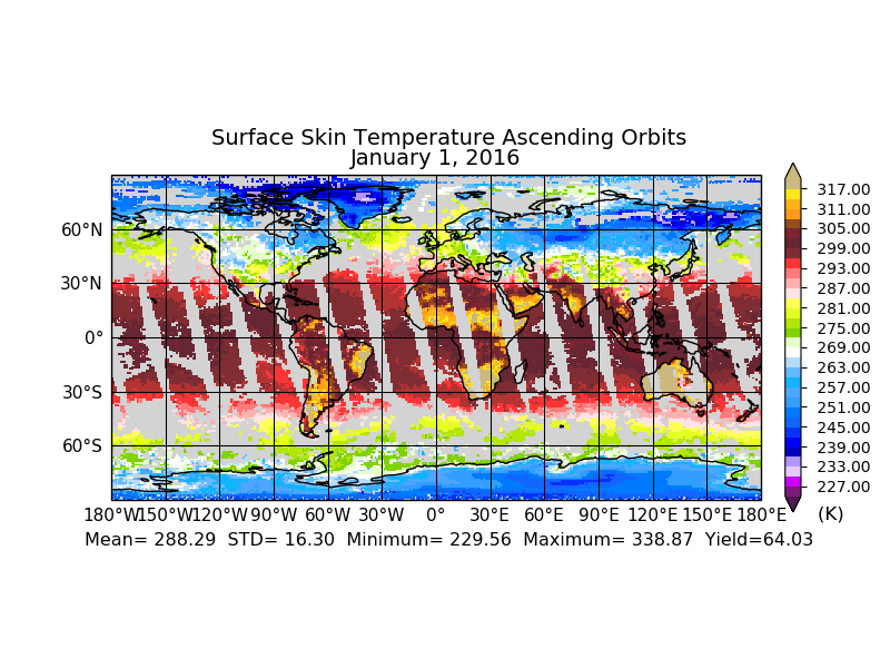
Federal
Aqua/AIRS L3 Daily Standard Physical Retrieval (AIRS-only) 1 degree x 1 degree V7.0 at GES DISC
National Aeronautics and Space Administration —
The Atmospheric Infrared Sounder (AIRS) is a grating spectrometer (R = 1200) aboard the second Earth Observing System (EOS) polar-orbiting platform, EOS Aqua. The...

Official websites use .gov
A
.gov website belongs to an official government
organization in the United States.
Secure .gov websites use HTTPS
A
lock (
) or https:// means you’ve safely connected to
the .gov website. Share sensitive information only on official,
secure websites.