
-
Federal
TIGER/Line Shapefile, 2023, County, Charles City County, VA, Linear Hydrography
U.S. Census Bureau, Department of Commerce —
The TIGER/Line shapefiles and related database files (.dbf) are an extract of selected geographic and cartographic information from the U.S. Census Bureau's Master... -
Federal
Land status and Federal mineral ownership in and around the Powder River Basin, WY and MT (prbplusown98g)
Department of the Interior —
This is a coverage of surface and Federal mineral ownership in the Powder River Basin area, Montana and Wyoming. This coverage is the combination of several ARC/INFO... -
Federal
Fermi LAT GRBs
National Aeronautics and Space Administration —
All analysis results presented here are preliminary and are not intended as an official catalog of Fermi-LAT detected GRBs. Please consult the table's caveat page for... -
Federal
TIGER/Line Shapefile, 2024, County, Wichita County, TX, Address Ranges Relationship File
U.S. Census Bureau, Department of Commerce —
The TIGER/Line shapefiles and related database files (.dbf) are an extract of selected geographic and cartographic information from the U.S. Census Bureau's Master... -
Federal
SupClas, GeoSet, SubType, VegDen, VegType: Categorical landcover rasters of landcover, geomorphic setting, substrate type, vegetation density, and vegetation type: Metompkin Island, VA, 2014
Department of the Interior —
Understanding how sea-level rise will affect coastal landforms and the species and habitats they support is critical for crafting approaches that balance the needs of... -
Federal
New Mexico Play Fairway Analysis: New Mexico Available Wells for Geochemical Sampling
Department of Energy —
This is a map package that is used to show the wells in New Mexico that may be available for geochemical sampling. -
Federal
Chemical and physical oceanographic profile data collected from CTD casts aboard the Wes Bordelon in the Gulf of Mexico from 2010-08-18 to 2010-08-22 in response to the Deepwater Horizon oil spill event (NCEI Accession 0069086)
National Oceanic and Atmospheric Administration, Department of Commerce —
Chemical and physical oceanographic profile data were collected aboard the Wes Bordelon in the Gulf of Mexico from 2010-08-18 to 2010-08-22 in response to the... -
Federal
TIGER/Line Shapefile, Current, County, Licking County, OH, Linear Hydrography
U.S. Census Bureau, Department of Commerce —
The TIGER/Line shapefiles and related database files (.dbf) are an extract of selected geographic and cartographic information from the U.S. Census Bureau's Master... -
Federal
TIGER/Line Shapefile, Current, County, Sussex County, DE, Linear Hydrography
U.S. Census Bureau, Department of Commerce —
The TIGER/Line shapefiles and related database files (.dbf) are an extract of selected geographic and cartographic information from the U.S. Census Bureau's Master... -
Federal
HOTA-ReID: Accelerated Higher Order Tracking Accuracy for Re-Identification
National Institute of Standards and Technology —
HOTA-ReID is a modified version of the Higher Order Tracking Accuracy (HOTA) metric specifically designed to support Re-Identification (ReID) problems while providing... -
Federal
BIA Surface Inventory (Great Plains Region), 2025
Department of the Interior —
Surface trust lands are displayed and summarized in a table by Tribal entity. A Tribal entity may be a federally recognized tribe or a constituent component of a... -
Federal
TIGER/Line Shapefile, 2022, County, St. Croix County, WI, Address Ranges Relationship File
U.S. Census Bureau, Department of Commerce —
The TIGER/Line shapefiles and related database files (.dbf) are an extract of selected geographic and cartographic information from the U.S. Census Bureau's Master... -
Federal
TIGER/Line Shapefile, 2024, County, Henry County, IN, All Lines
U.S. Census Bureau, Department of Commerce —
The TIGER/Line shapefiles and related database files (.dbf) are an extract of selected geographic and cartographic information from the U.S. Census Bureau's Master... -
Federal
TIGER/Line Shapefile, Current, County, Garfield County, WA, All Roads
U.S. Census Bureau, Department of Commerce —
This resource is a member of a series. The TIGER/Line shapefiles and related database files (.dbf) are an extract of selected geographic and cartographic information... -
Federal
Red Grouper Sound Production Recorded at SanctSound Site FK01_01
National Oceanic and Atmospheric Administration, Department of Commerce —
This record represents red grouper sound production detected from raw passive acoustic data. For each one-minute segment of data, calibrated spectrograms were... -
Federal
TIGER/Line Shapefile, 2022, County, Simpson County, KY, Linear Hydrography
U.S. Census Bureau, Department of Commerce —
The TIGER/Line shapefiles and related database files (.dbf) are an extract of selected geographic and cartographic information from the U.S. Census Bureau's Master... -
Federal
Phytoplankton data for Stagecoach Reservoir near Steamboat Springs, Colorado, (ver. 2.0, December 2025)
Department of the Interior —
This U.S. Geological Survey (USGS) data release provides phytoplankton data collected from Stagecoach Reservoir, Colorado, during the summer months, July through... -
Federal
Shoreline Mapping Program of SHEBOYGAN, WI, WI0401 NGDA
National Oceanic and Atmospheric Administration, Department of Commerce —
These data provide an accurate high-resolution shoreline compiled from imagery of SHEBOYGAN, WI . This vector shoreline data is based on an office interpretation of... -
Federal
TIGER/Line Shapefile, 2023, County, Pamlico County, NC, All Roads
U.S. Census Bureau, Department of Commerce —
The TIGER/Line shapefiles and related database files (.dbf) are an extract of selected geographic and cartographic information from the U.S. Census Bureau's Master... -
Federal
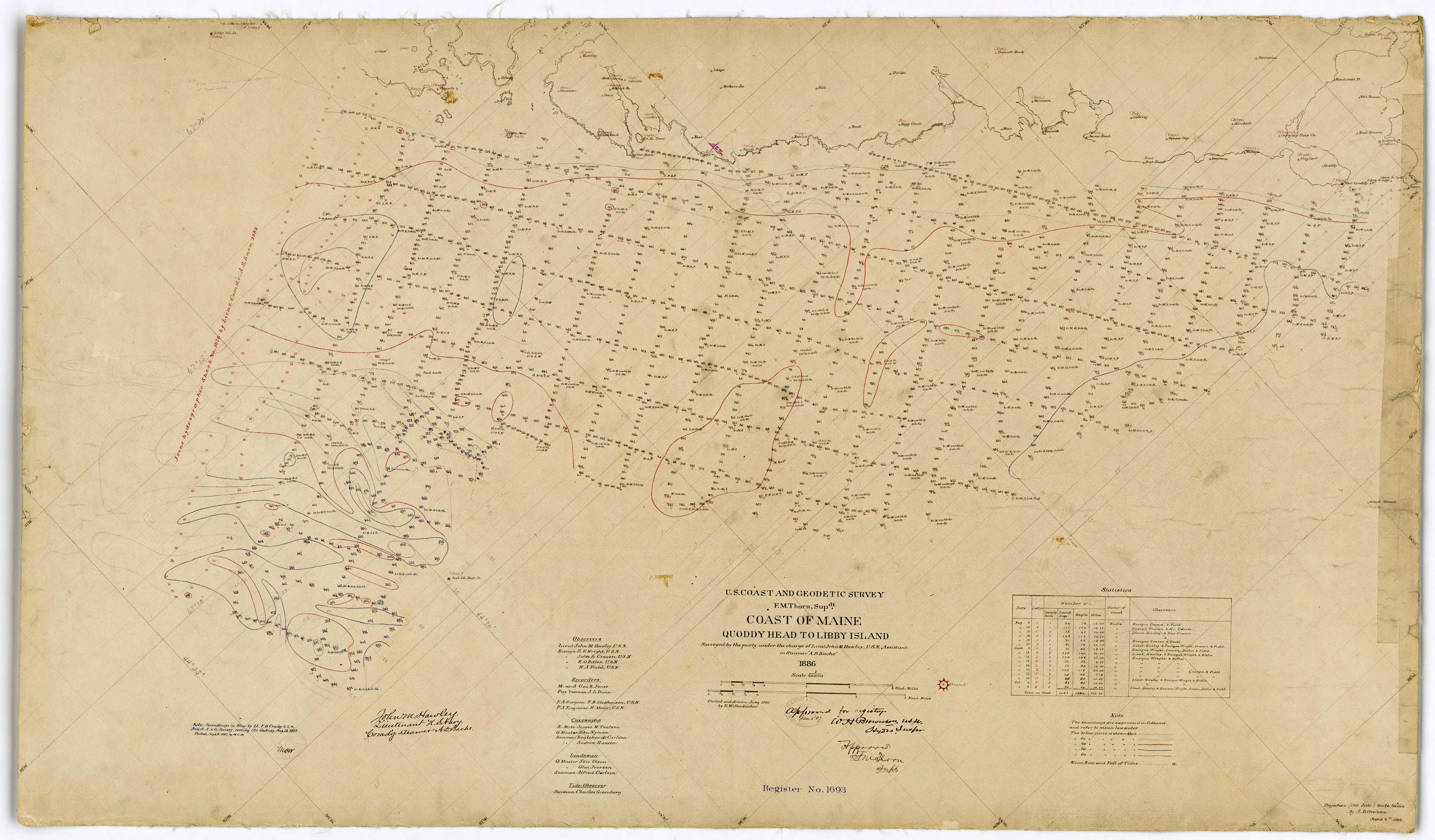
H01693: NOS Hydrographic Survey , 1887-12-31
National Oceanic and Atmospheric Administration, Department of Commerce —
The National Oceanic and Atmospheric Administration (NOAA) has the statutory mandate to collect hydrographic data in support of nautical chart compilation for safe...

Official websites use .gov
A
.gov website belongs to an official government
organization in the United States.
Secure .gov websites use HTTPS
A
lock (
) or https:// means you’ve safely connected to
the .gov website. Share sensitive information only on official,
secure websites.