
-
Federal
Deterministic Move Lists for Federal Incumbent Protection in the CBRS Band
Department of Commerce —
The 3.5 GHz citizens broadband radio service (CBRS) band in the U.S. is a key portion of mid-band spectrum shared between commercial operators and existing federal... -
Federal
Active Transportation Demand Management (ATDM) Trajectory Level Validation
Department of Transportation —
The ATDM Trajectory Validation project developed a validation framework and a trajectory computational engine to compare and validate simulated and observed vehicle... -
Federal
Yucatan 6km Sea Surface Currents
National Oceanic and Atmospheric Administration, Department of Commerce —
Radial Vectors quality controlled using hfradarpy Python toolbox -
Federal
Rutgers, Realtime Waves 13mhz Brnt
National Oceanic and Atmospheric Administration, Department of Commerce —
Mid-Atlantic Regional Association Coastal Ocean Observing System (MARACOOS) Wave Heights. Ocean Wave Heights. Center for Ocean Observing and Leadership, Department of... -
Federal
GPM Ground Validation NEXRAD Level III KDMX IFloodS V1
National Aeronautics and Space Administration —
The GPM Ground Validation NEXRAD Level III KDMX IFloodS dataset contain precipitation products derived from selected NEXt Generation Weather RADar system (NEXRAD)... -
Federal
SWOT Level 1B High-Rate Single-look Complex Data Product, Version 2.0
National Aeronautics and Space Administration —
High rate data processed to single-look complex SAR images for each antenna. Gridded tile (approx 64x64 km2); half swath (left or right side of full swath). Available... -
Federal
Airborne Precipitation Radar 3rd Generation (APR-3) CPEX V1
National Aeronautics and Space Administration —
The Airborne Precipitation Radar 3rd Generation (APR-3) CPEX dataset consists of radar reflectivity, Doppler velocity for all bands, linear depolarization ratio Ku-... -
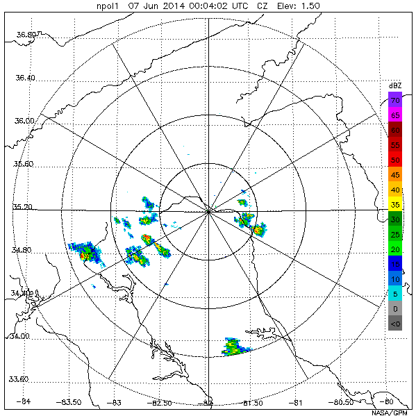
Federal
GPM Ground Validation NASA S-Band Dual Polarimetric (NPOL) Doppler Radar IPHEx V1
National Aeronautics and Space Administration —
The GPM Ground Validation NASA S-Band Dual Polarimetric (NPOL) Doppler Radar IPHEx dataset was collected during the GPM Ground Validation Integrated Precipitation and... -
Federal
Marathon, FL (MARA) Long Range Radial Currents
National Oceanic and Atmospheric Administration, Department of Commerce —
Radial Vectors quality controlled using HFRadarPyPython toolbox -
Federal
Rutgers, Realtime Waves 13mhz CMPT
National Oceanic and Atmospheric Administration, Department of Commerce —
Mid-Atlantic Regional Association Coastal Ocean Observing System (MARACOOS) Wave Heights. Ocean Wave Heights. Center for Ocean Observing and Leadership, Department of... -
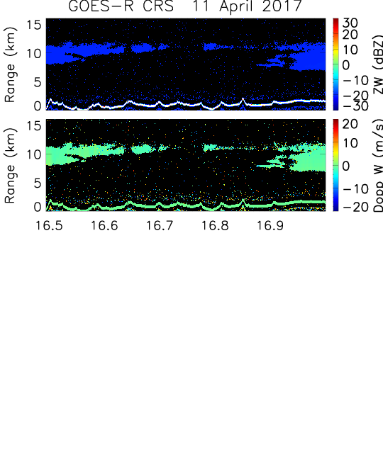
Federal
GOES-R PLT Cloud Radar System (CRS) V1
National Aeronautics and Space Administration —
The GOES-R PLT Field Campaign Cloud Radar System (CRS) dataset provides high-resolution profiles of reflectivity and Doppler velocity at aircraft nadir along the... -
Federal
Sentinel-1 Input Data for PSInSAR Analysis
Department of Energy —
Files used to perform the Persistent Scatterer InSAR analysis with SARPROZ. The data is sourced from ESAs Sentinel-1 project and covers Brady Hot Springs and Desert... -
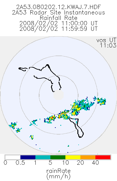
Federal
TRMM Ground Validation Radar Site Rain Rate Map L2 1 hour 2 km V7 (TRMM_2A53UW) at GES DISC
National Aeronautics and Space Administration —
This dataset is part of the University of Washington TRMM Ground Validation products. Instantaneous rain rate cartesian grid based on baseUW and 2A54UW. Units are... -
Federal
Currents, HF Radar, Puerto Rico and the US Virgin Islands, RTV, Near-Real Time, 2012-present, Hourly, 6km
National Oceanic and Atmospheric Administration, Department of Commerce —
Surface ocean velocities estimated from HF-Radar are representative of the upper 2.4 meters of the ocean. The main objective of near-real time processing is to... -
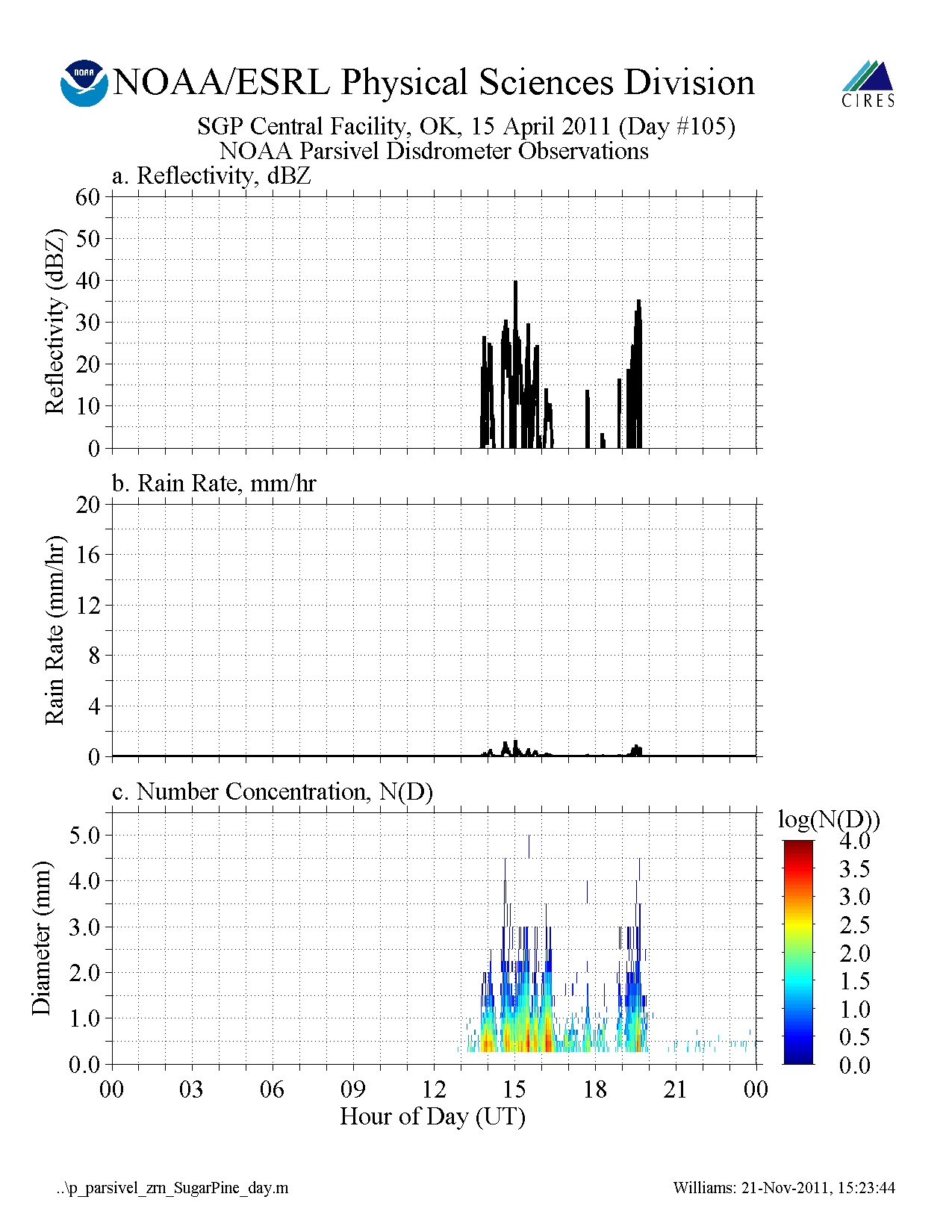
Federal
GPM GROUND VALIDATION NOAA PARSIVEL MC3E V1
National Aeronautics and Space Administration —
The GPM Ground Validation NOAA Parsivel MC3E dataset was collected in central Oklahoma during the Midlatitude Continental Convective Clouds Experiment (MC3E) from... -
Federal
SMAPVEX08 PALS Backscatter Data V001
National Aeronautics and Space Administration —
This data set contains backscatter data obtained by the Passive Active L-band System (PALS) microwave aircraft radar instrument as part of the Soil Moisture Active... -
Federal
Currents, HF Radar, US East Coast and Gulf of Mexico, RTV, Near-Real Time, 2012-present, Hourly, 2km, Lon0360
National Oceanic and Atmospheric Administration, Department of Commerce —
Surface ocean velocities estimated from HF-Radar are representative of the upper 1.0 meters of the ocean. The main objective of near-real time processing is to... -
Federal
Currents, HF Radar, US West Coast, RTV, Near-Real Time, 2012-present, Hourly, 6km, Lon0360
National Oceanic and Atmospheric Administration, Department of Commerce —
Surface ocean velocities estimated from HF-Radar are representative of the upper 2.4 meters of the ocean. The main objective of near-real time processing is to... -
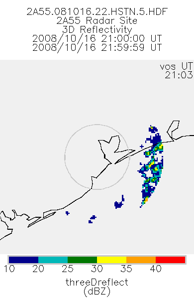
Federal
TRMM Ground Validation Radar Site 3D Reflectivity L2 1 hour V7 (TRMM_2A55) at GES DISC
National Aeronautics and Space Administration —
'Radar Site 3-D Reflectivities', is composed of 3 different fields. The first field has an array of 3-D reflectivities in Cartesian coordinates with a 2 km horizontal... -
Federal
BLM OR Remote Sensing Satellite Project Polygon Hub
Department of the Interior —
SATELLITE_PROJECT_POLY: Merged individual polygons from Satellite_Project_Poly for the area of BLM lands in Oregon and Washington.

Official websites use .gov
A
.gov website belongs to an official government
organization in the United States.
Secure .gov websites use HTTPS
A
lock (
) or https:// means you’ve safely connected to
the .gov website. Share sensitive information only on official,
secure websites.