
-
Federal
Natural Resource Protection and Child Health Indicators, 2013 Release
National Aeronautics and Space Administration —
The Natural Resource Protection and Child Health Indicators, 2013 Release, are produced in support of the U.S. Millennium Challenge Corporation as selection criteria... -
Federal
Trends in Global Freshwater Availability from the Gravity Recovery and Climate Experiment (GRACE)
National Aeronautics and Space Administration —
The Trends in Global Freshwater Availability from the Gravity Recovery and Climate Experiment (GRACE), 2002-2016, is a global gridded data set at a spatial resolution... -
Federal
Natural Resource Protection and Child Health Indicators, 2017 Release
National Aeronautics and Space Administration —
The Natural Resource Protection and Child Health Indicators, 2017 Release, is produced in support of the U.S. Millennium Challenge Corporation (MCC) as selection... -
Federal
West Africa Coastal Vulnerability Mapping: GPW Version 4 Population Growth, Preliminary Release 1, 2000-2010
National Aeronautics and Space Administration —
The West Africa Coastal Vulnerability Mapping: GPW Version 4 Population Growth, Preliminary Release 1, 2000-2010, represents positive or negative growth in the number... -
Federal
Archive of Census Related Products (ACRP): 1990 SAS Transport Files
National Aeronautics and Space Administration —
The 1990 SAS Transport Files portion of the Archive of Census Related Products (ACRP) contains housing and population data from the U.S. Census Bureau's 1990 Summary... -
Federal
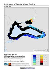
Indicators of Coastal Water Quality: Change in Chlorophyll-a Concentration 1998-2007
National Aeronautics and Space Administration —
The Change in Chlorophyll-a Concentrations 1998-2007 component of the Indicators of Coastal Water Quality Collection represents a tabular time series of the... -
Federal
Compendium of Environmental Sustainability Indicator Collections: Ancillary Data
National Aeronautics and Space Administration —
The Ancillary Data portion of the Compendium of Environmental Sustainability Indicator Collections contains 38 variables (time series data on population and gross... -
Federal
U.S. EPA National Priorities List (NPL) Sites Point Data with CIESIN Modifications, Version 2
National Aeronautics and Space Administration —
The U.S. Environmental Protection Agency (EPA) National Priorities List (NPL) Sites Point Data with CIESIN Modifications, Version 2 is a modified version of the 2014... -
Federal
West Africa Coastal Vulnerability Mapping: Subset of High and Low Resolution Altimeter Corrected Elevations 2 (ACE2)
National Aeronautics and Space Administration —
The West Africa Coastal Vulnerability Mapping: Subset of High and Low Resolution Altimeter Corrected Elevations 2 (ACE2) data set consists of extracts from the 3 arc-... -
Federal
West Africa Coastal Vulnerability Mapping: Subset of Global Mammal and Amphibian Richness Grids, 2015 Release
National Aeronautics and Space Administration —
The West Africa Coastal Vulnerability Mapping: Subset of Global Mammal and Amphibian Richness Grids, 2015 Release was extracted from the NASA Socioeconomic Data and... -
Federal
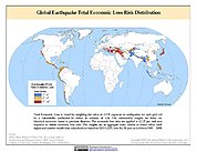
Global Earthquake Total Economic Loss Risk Deciles
National Aeronautics and Space Administration —
The Global Earthquake Total Economic Loss Risk Deciles is a 2.5 minute grid of global earthquake total economic loss risks. A process of spatially allocating Gross... -
Federal
Indicators of Coastal Water Quality: Ancillary Data
National Aeronautics and Space Administration —
The Ancillary Data component of the Indicators of Coastal Water Quality Collection includes a 5 arc-minute (approximately 9 x 9 km at the equator) sequence grid, grid... -
Federal
Millennium Ecosystem Assessment: MA Ecosystems
National Aeronautics and Space Administration —
The Millennium Ecosystem Assessment: MA Ecosystems provides data and information on the extent and classification of ecosystems circa 2000, including coastal,... -
Federal
Last of the Wild Project, Version 1, 2002 (LWP-1): Top One Percent Wild Areas Dataset (IGHP)
National Aeronautics and Space Administration —
The Top One Percent Wild Areas Dataset of the Last of the Wild Project, Version 1, 2002 (LWP-1) is derived from the LWP-1 Human Footprint Dataset. The gridded data... -
Federal
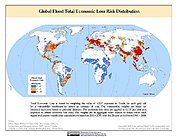
Global Flood Total Economic Loss Risk Deciles
National Aeronautics and Space Administration —
The Global Flood Total Economic Loss Risk Deciles is a 2.5 minute grid of global flood total economic loss risks. A process of spatially allocating Gross Domestic... -
Federal
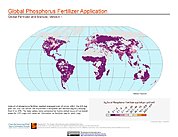
Global Fertilizer and Manure, Version 1: Phosphorus Fertilizer Application
National Aeronautics and Space Administration —
The Phosphorus Fertilizer Application data set of the Global Fertilizer and Manure, Version 1 Data Collection represents the amount of phosphorus fertilizer nutrients... -
Federal
Global Fire Emissions Indicators, Country-Level Tabular Data: 1997-2015
National Aeronautics and Space Administration —
The Global Fire Emissions Indicators, Country-Level Tabular Data: 1997-2015 contains country tabulations from 1997 to 2015 for the total area burned (hectares) and... -
Federal
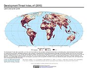
Development Threat Index
National Aeronautics and Space Administration —
The Development Threat Index data set is a terrestrial global, future development threat map based on combining these resources: agricultural expansion, urban... -
Federal
Natural Resource Management Index (NRMI), 2011 Release
National Aeronautics and Space Administration —
The Natural Resource Management Index (NRMI), 2011 Release is a composite index for 174 countries derived from the average of four proximity-to-target indicators for... -
Federal
Natural Resource Protection and Child Health Indicators, 2018 Release
National Aeronautics and Space Administration —
The Natural Resource Protection and Child Health Indicators, 2018 Release, is produced in support of the U.S. Millennium Challenge Corporation (MCC) as selection...

Official websites use .gov
A
.gov website belongs to an official government
organization in the United States.
Secure .gov websites use HTTPS
A
lock (
) or https:// means you’ve safely connected to
the .gov website. Share sensitive information only on official,
secure websites.