
-
University
Colfax County 2010 Census Block Groups
Earth Data Analysis Center, University of New Mexico —
The TIGER/Line Files are shapefiles and related database files (.dbf) that are an extract of selected geographic and cartographic information from the U.S. Census... -
University
Current 3-Digit ZIP Code Tabulation Areas (ZCTAs) for Roosevelt County, New Mexico, 2006se TIGER
Earth Data Analysis Center, University of New Mexico —
The 2006 Second Edition TIGER/Line files are an extract of selected geographic and cartographic information from the Census TIGER database. The geographic coverage... -
University
Current 5-Digit ZIP Code Tabulation Areas (ZCTAs) for Mora County, New Mexico, 2006se TIGER
Earth Data Analysis Center, University of New Mexico —
The 2006 Second Edition TIGER/Line files are an extract of selected geographic and cartographic information from the Census TIGER database. The geographic coverage... -
Federal
Low-Income Housing Tax Credit (LIHTC) Difficult Development Areas
Department of Housing and Urban Development —
This service provides spatial data and information on Difficult Development Areas (DDAs) used for the Low Income Housing Tax Credit program. DDAs are designated by... -
City
Births byZCTA 2014
City of Ferndale, Michigan —
This dataset contains birth information, by Zip Code Tabulation Areas, for the state of Michigan in 2014. Included are births by ethnicity, number of births with... -
Federal
TIGER/Line Shapefile, 2018, nation, U.S., Current Tribal Block Group National
U.S. Census Bureau, Department of Commerce —
The TIGER/Line shapefiles and related database files (.dbf) are an extract of selected geographic and cartographic information from the U.S. Census Bureau's Master... -
City
Louisville Metro KY - Crime Data 2018
Louisville Metro Government —
Crime report data is provided for Louisville Metro Police Divisions only; crime data does not include smaller class cities.The data provided in this dataset is... -
City
Louisville Metro KY – COVID-19 Response to Prevention in Congregate Setting Program
Louisville Metro Government —
LMPHW will be sub granting ARP funds to Metro United Way to deploy critical funding to childcare providers reeling from the effects of COVID-19, which will help... -
City
Louisville Metro KY - Uniform Citation Data 2022
Louisville Metro Government —
Note: Due to a system migration, this data will cease to update on March 14th, 2023. The current projection is to restart the updates on or around July 17th, 2024.A... -
University
De Baca County 2010 Census Tracts
Earth Data Analysis Center, University of New Mexico —
The TIGER/Line Files are shapefiles and related database files (.dbf) that are an extract of selected geographic and cartographic information from the U.S. Census... -
State
American Coot Range - CWHR B149 [ds1458]
State of California —
Vector datasets of CWHR range maps are one component of California Wildlife Habitat Relationships (CWHR), a comprehensive information system and predictive model for... -
University
Raton 1:100000 Quad Transportation DLGs
Earth Data Analysis Center, University of New Mexico —
Digital line graph (DLG) data are digital representations of cartographic information. DLG's of map features are converted to digital form from maps and related... -
Federal
Unpublished Digital Geomorphic Map of the Shackleford Banks, North Carolina (NPS, GRD, GRI, CALO, SHKB digital map) adapted from a East Carolina University unpublished report and GIS data map by Riggs, Ames and Mallinson (2015)
Department of the Interior —
The Unpublished Digital Geomorphic Map of the Shackleford Banks, North Carolina is composed of GIS data layers and GIS tables in a 10.1 file geodatabase... -
Federal
Vegetation Species Reference (FIFE)
National Aeronautics and Space Administration —
The Konza Natural Research Area is a tallgrass prairie in a biologically heterogeneous environment that is rich in native plant species. Species composition is... -
Federal
SPURS-2 Drifter data for the E. Tropical Pacific field campaign
National Aeronautics and Space Administration —
The SPURS (Salinity Processes in the Upper Ocean Regional Study) project is a NASA-funded oceanographic process study and associated field program that aim to... -
Federal
SAFARI 2000 Carbon in Live Vegetation, 0.5-Deg (Olson)
National Aeronautics and Space Administration —
This data set is a subset of Olson's Major World Ecosystem Complexes for southern Africa in ASCII GRID and binary image files formats. Olson's Major World Ecosystem... -
Federal
SAFARI 2000 MODIS MOD05_L2 Water Vapor Data, Binary Format, for Southern Africa
National Aeronautics and Space Administration —
The Moderate Resolution Imaging Spectroradiometer (MODIS) precipitable water product consists of vertical column water-vapor amounts in centimeters (cm) at 1-km... -
Federal
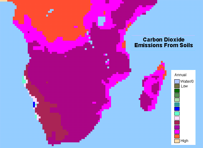
SAFARI 2000 Monthly and Annual CO2 Emissions from Soil, 0.5 Degree Grid
National Aeronautics and Space Administration —
The data set provides estimated monthly and annual soil CO2 emissions for southern Africa (the SAFARI 2000 project region). The calculated emissions are from the...

Official websites use .gov
A
.gov website belongs to an official government
organization in the United States.
Secure .gov websites use HTTPS
A
lock (
) or https:// means you’ve safely connected to
the .gov website. Share sensitive information only on official,
secure websites.