
-
County
Redlining Maps from the Home Owners Loan Corporation, 1937
Allegheny County / City of Pittsburgh / Western PA Regional Data Center —
Most of the text in this description originally appeared on the Mapping Inequality Website. Robert K. Nelson, LaDale Winling, Richard Marciano, Nathan Connolly, et... -
Federal
Global Flood Hazard Frequency and Distribution
National Aeronautics and Space Administration —
The Global Flood Hazard Frequency and Distribution is a 2.5 minute grid derived from a global listing of extreme flood events between 1985 and 2003 (poor or missing... -
Federal
Global Landslide Hazard Distribution
National Aeronautics and Space Administration —
The Global Landslide Hazard Distribution is a 2.5 minute grid of global landslide and snow avalanche hazards based upon work of the Norwegian Geotechnical Institute... -
Federal
U.S. Climate Risk Projections by County, 2040-2049
National Aeronautics and Space Administration —
The U.S. Climate Risk Projections by County, 2040-2049 data set contains a projection for 2040-2049 risk for the entire contiguous U.S. at the county level with a... -
Federal
Global Landslide Mortality Risks and Distribution
National Aeronautics and Space Administration —
The Global Landslide Mortality Risks and Distribution is a 2.5 minute grid of global landslide mortality risks. Gridded Population of the World, Version 3 (GPWv3)... -
Federal
ABoVE: Boreal Forest Resilience Study 2020-2022, Fairbanks AK
National Aeronautics and Space Administration —
This dataset includes five metrics of forest resilience (recruitment, invasives, permafrost change, tree damage, and radial growth) at five recently burned forest... -
Federal
MASTER: FireSense, California and Southern US, Spring 2025
National Aeronautics and Space Administration —
This dataset includes Level 1B (L1B) and Level 2 (L2) data products from the MODIS/ASTER Airborne Simulator (MASTER) instrument. The spectral data were collected as... -
Federal
Global Drought Proportional Economic Loss Risk Deciles
National Aeronautics and Space Administration —
The Global Drought Proportional Economic Loss Risk Deciles is a 2.5 minute grid of drought hazard economic loss as proportions of Gross Domestic Product (GDP) per... -
Federal
Global Volcano Hazard Frequency and Distribution
National Aeronautics and Space Administration —
Global Volcano Hazard Frequency and Distribution is a 2.5 minute gridded data set based upon the National Geophysical Data Center (NGDC) Volcano Database spanning the... -
Federal
MASTER: Student Airborne Research Program (SARP) campaign, California, USA, 2016
National Aeronautics and Space Administration —
This dataset includes Level 1B (L1B) data products from the MODIS/ASTER Airborne Simulator (MASTER) instrument collected and developed by the Student Airborne... -
Federal
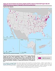
ATSDR Hazardous Waste Site Polygon Data with CIESIN Modifications, Version 2
National Aeronautics and Space Administration —
The Agency for Toxic Substances and Disease Registry (ATSDR) Hazardous Waste Site Polygon Data with CIESIN Modifications, Version 2 is a database providing... -
Federal
Global Multihazard Mortality Risks and Distribution
National Aeronautics and Space Administration —
The Global Multihazard Mortality Risks and Distribution is a 2.5 minute grid identifying and characterizing the nature of multihazard risk at the global scale. For... -
Federal
ABoVE: Active Layer Soil Characteristics at Selected Sites Across Alaska
National Aeronautics and Space Administration —
This dataset provides soil active layer characteristics from nine locations across Alaska. Soil samples were collected in 2016 except for one site which was sampled... -
Federal
ABoVE: Characterization of Carbon Dynamics in Burned Forest Plots, NWT, Canada, 2014
National Aeronautics and Space Administration —
This dataset provides field data from boreal forests in the Northwest Territories (NWT), Canada, that were burned by wildfires in 2014. During fieldwork in 2015, 211... -
Federal
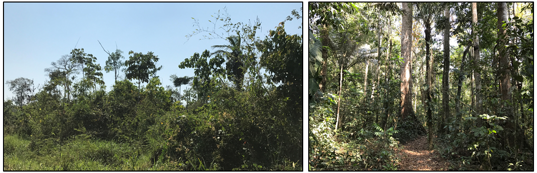
Forest Inventories and DBH at Burned and Unburned Forest Sites, Acre, Brazil, 2017
National Aeronautics and Space Administration —
This data set provides measurements of diameter at breast height (DBH) and species identification at four forest sites in the eastern side of Acre, Brazil including... -
Federal
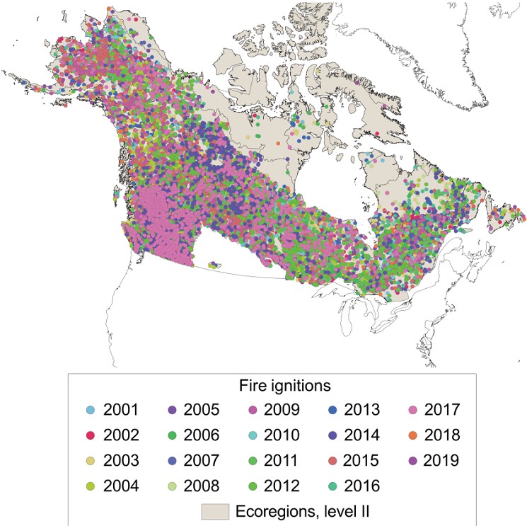
ABoVE: Ignitions of ABoVE-FED Fires in Alaska and Canada
National Aeronautics and Space Administration —
This dataset provides daily fire ignition locations and timing for boreal fires in Alaska, U.S., and Canada between 2001 and 2019. The fire ignition locations and... -
Federal
MODIS/Terra+Aqua Direct Broadcast Burned Area Monthly L3 Global 500m SIN Grid V006
National Aeronautics and Space Administration —
The MCD64A1 Version 6 data product was decommissioned on July 31, 2023. Users are encouraged to use the MCD64A1 Version 6.1 data product.The Terra and Aqua combined... -
Federal
Low Elevation Coastal Zone (LECZ) Urban-Rural Population and Land Area Estimates, Version 3
National Aeronautics and Space Administration —
The Low Elevation Coastal Zone (LECZ) Urban-Rural Population and Land Area Estimates, Version 3 data set contains land areas with urban, quasi-urban, rural, and total... -
Federal
Global Earthquake Hazard Distribution - Peak Ground Acceleration
National Aeronautics and Space Administration —
The Global Earthquake Hazard Distribution - Peak Ground Acceleration is a 2.5 minute grid of global earthquake hazards developed using Global Seismic Hazard Program...

Official websites use .gov
A
.gov website belongs to an official government
organization in the United States.
Secure .gov websites use HTTPS
A
lock (
) or https:// means you’ve safely connected to
the .gov website. Share sensitive information only on official,
secure websites.