
-
Federal
Global Volcano Hazard Frequency and Distribution
National Aeronautics and Space Administration —
Global Volcano Hazard Frequency and Distribution is a 2.5 minute gridded data set based upon the National Geophysical Data Center (NGDC) Volcano Database spanning the... -
Federal
Global Multihazard Frequency and Distribution
National Aeronautics and Space Administration —
The Global Multihazard Frequency and Distribution is a 2.5 minute grid presenting a simple multihazard index based solely on summated single-hazard decile values. The... -
Federal
Newberry EGS Demonstration: Well 55-29 Stimulation Data 2014
Department of Energy —
The Newberry Volcano EGS Demonstration in central Oregon, a 5 year project begun in 2010, tests recent technological advances designed to reduce the cost of power... -
Federal
Global Multihazard Mortality Risks and Distribution
National Aeronautics and Space Administration —
The Global Multihazard Mortality Risks and Distribution is a 2.5 minute grid identifying and characterizing the nature of multihazard risk at the global scale. For... -
Federal
VIIRS/NPP Active Fires 6-Min L2 Swath 375m V002
National Aeronautics and Space Administration —
The Visible Infrared Imaging Radiometer Suite (VIIRS) Active Fires (VNP14IMG) Version 2 product is produced in 6-minute temporal satellite increments (swaths) at 375... -
Federal
Global Multihazard Total Economic Loss Risk Deciles
National Aeronautics and Space Administration —
The Global Multihazard Total Economic Loss Risk Deciles is a 2.5 minute grid of global multihazard total economic loss risks. First, for each of the considered... -
Federal
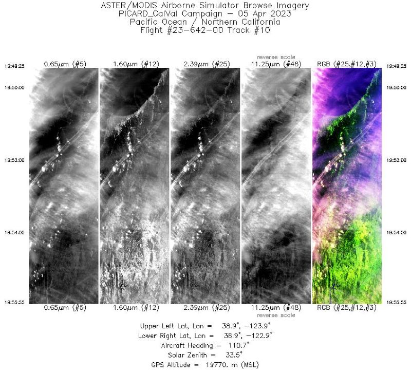
MASTER: Western Diversity Time Series Campaign, WDTS, Spring 2023
National Aeronautics and Space Administration —
This dataset includes Level 1B (L1B) and Level 2 (L2) data products from the MODIS/ASTER Airborne Simulator (MASTER) instrument. The spectral data were collected as... -
Federal
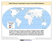
Global Volcano Proportional Economic Loss Risk Deciles
National Aeronautics and Space Administration —
Global Volcano Proportional Economic Loss Risk Deciles is a 2.5 minute grid of volcano hazard economic loss as proportions of Gross Domestic Product (GDP) per... -
Federal
MASTER: HyspIRI Airborne Campaign, Hawaii, 2018
National Aeronautics and Space Administration —
This dataset includes Level 1B (L1B) and Level 2 (L2) data products from the MODIS/ASTER Airborne Simulator (MASTER) instrument. The spectral data were collected as... -
Federal
Newberry EGS Demonstration: Well 55-29 Stimulation Data
Department of Energy —
The Newberry Volcano EGS Demonstration in central Oregon, a 3 year project started in 2010, tests recent technological advances designed to reduce the cost of power... -
Federal
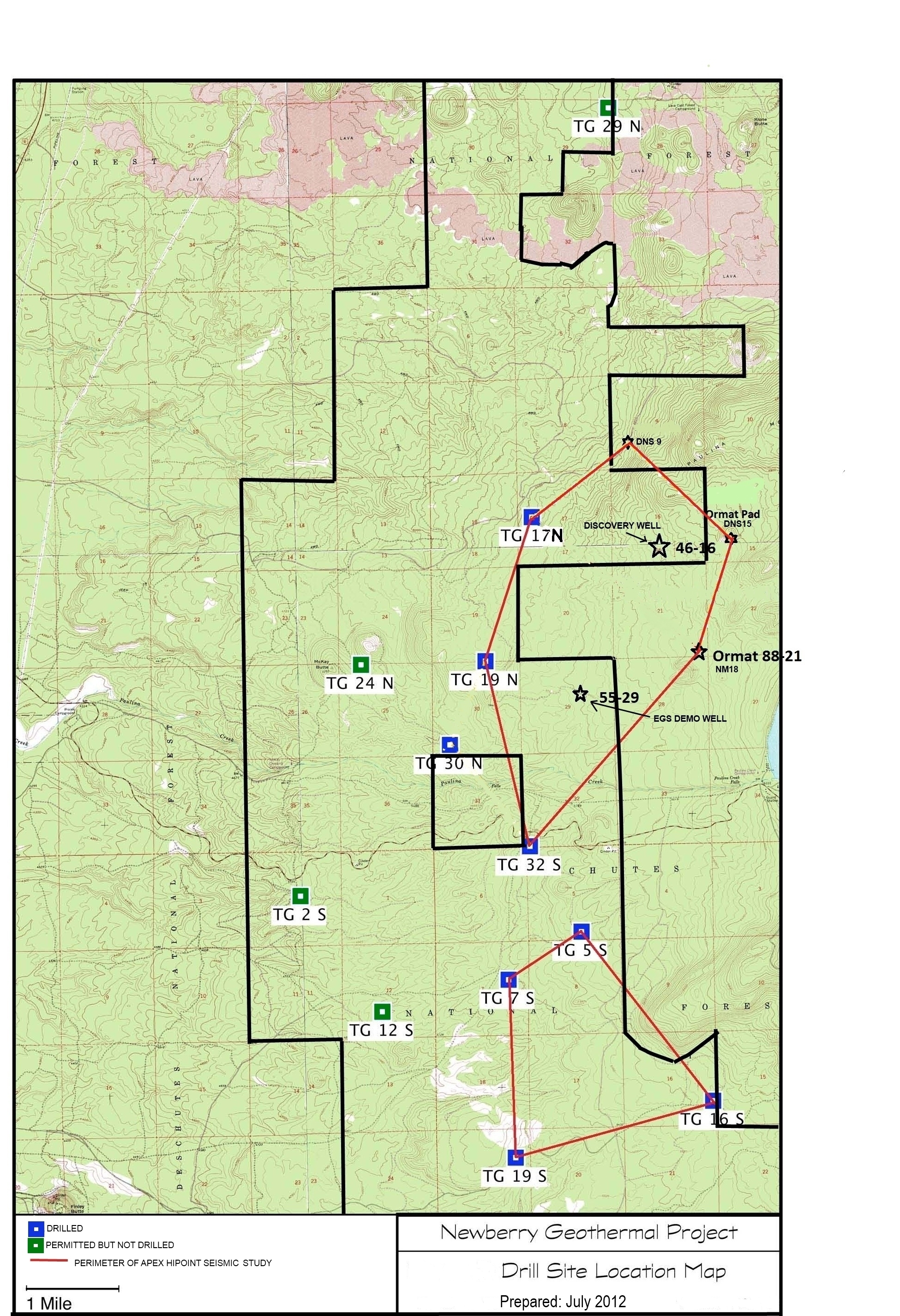
Validation of Innovative Exploration Technologies for Newberry Volcano: Drill Site Location Map
Department of Energy —
Newberry seeks to explore "blind" (no surface evidence) convective hydrothermal systems associated with a young silicic pluton on the flanks of Newberry Volcano. This... -
Federal
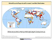
Global Multihazard Proportional Economic Loss Risk Deciles
National Aeronautics and Space Administration —
The Global Multihazard Proportional Economic Loss Risks is a 2.5 minute grid of a multihazard-based economic loss risk as a proportion of the economic productivity of... -
Federal
Map of Validation of Innovative Exploration Technologies for Newberry Volcano
Department of Energy —
A map showing location of wells permitted, drilled and seismic test, as part of validation of innovative exploration technologies done for the Newberry Volcano... -
Federal
MODIS/Aqua Thermal Anomalies/Fire 5-Min L2 Swath 1km V061
National Aeronautics and Space Administration —
The Aqua Moderate Resolution Imaging Spectroradiometer (MODIS) Thermal Anomalies and Fire (MYD14) Version 6.1 product is produced daily in 5-minute temporal satellite... -
Federal
VIIRS/NPP Thermal Anomalies/Fire 6-Min L2 Swath 750m V002
National Aeronautics and Space Administration —
The Visible Infrared Imaging Radiometer Suite (VIIRS) Thermal Anomalies (VNP14) Version 2 product is produced in 6-minute temporal satellite increments (swaths) at... -
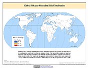
Federal
Global Volcano Mortality Risks and Distribution
National Aeronautics and Space Administration —
Global Volcano Mortality Risks and Distribution is a 2.5 minute grid representing global volcano mortality risks. The data set was constructed using historical... -
Federal
VIIRS/JPSS1 Thermal Anomalies/Fire 6-Min L2 Swath 750m V002
National Aeronautics and Space Administration —
The Visible Infrared Imaging Radiometer Suite (VIIRS) Thermal Anomalies (VJ114) Version 2 product is produced in 6-minute temporal satellite increments (swaths) at... -
Federal
MODIS/Terra Thermal Anomalies/Fire 5-Min L2 Swath 1km V061
National Aeronautics and Space Administration —
The Moderate Resolution Imaging Spectroradiometer (MODIS) Thermal Anomalies and Fire MOD14 Version 6.1 product is produced daily in 5-minute temporal satellite... -
Federal
Global Volcano Total Economic Loss Risk Deciles
National Aeronautics and Space Administration —
Global Volcano Total Economic Loss Risk Deciles is a 2.5 minute grid of global volcano total economic loss risks. First, subnational distributions of Gross Domestic... -
Federal
MASTER: HyspIRI Airborne Campaign, Hawaii, 2017
National Aeronautics and Space Administration —
This dataset includes Level 1B (L1B) and Level 2 (L2) data products from the MODIS/ASTER Airborne Simulator (MASTER) instrument. The spectral data were collected as...

Official websites use .gov
A
.gov website belongs to an official government
organization in the United States.
Secure .gov websites use HTTPS
A
lock (
) or https:// means you’ve safely connected to
the .gov website. Share sensitive information only on official,
secure websites.