

267 datasets found for "77n주식디비@텔레그램RADARDB-"
-
Federal
Process-structure-properties investigations for laser powder bed fused IN718 in the as-built condition
National Institute of Standards and Technology —
This data repository provides a central location for a body of work using one build of nickel-based alloy 718 (IN718) material and resulted in three different... -
Federal
Airport and Heliport Setbacks
Department of Energy —
This dataset represents a first-order quantification of airport and heliport setback requirements based on the Federal Aviation Administration (FAA) 14 CFR Part 77.9.... -
Federal
Project HOTSPOT: Kimberly Well Borehole Geophysics Database
Department of Energy —
The Snake River Plain (SRP), Idaho, hosts potential geothermal resources due to elevated groundwater temperatures associated with the thermal anomaly Yellowstone-... -
Federal
Global 1-km Gridded Thickness of Soil, Regolith, and Sedimentary Deposit Layers
National Aeronautics and Space Administration —
This data set provides high-resolution estimates of the thickness of the permeable layers above bedrock (soil, regolith, and sedimentary deposits) within a global... -
Federal
SWOT Level 2 Nadir Altimeter Operational Geophysical Data Record with Waveforms Version 1.0
National Aeronautics and Space Administration —
The SWOT Level 2 Nadir Altimeter Operational Geophysical Data Record (OGDR) with Waveforms Version 1.0 dataset produced by the Surface Water and Ocean Topography... -
Federal
ABoVE: High Resolution Cloud-Free Snow Cover Extent and Snow Depth, Alaska, 2001-2017
National Aeronautics and Space Administration —
This dataset provides estimates of maximum snow cover extent (SCE) and snow depth for each 8-day composite period from 2001 to 2017 at 1 km resolution across Alaska.... -
Federal
Snake River Plain Geothermal Play Fairway Analysis Heat, Permeability, and Seal CRS Map Raster Files
Department of Energy —
Snake River Plain Play Fairway Analysis - Phase 1 CRS Raster Files. This dataset contains raster files created in ArcGIS. These raster images depict Common Risk... -
Federal
Calibration Data for Wafer 2 of SRM 3461 - MEMS Cantilever Stiffness
National Institute of Standards and Technology —
SRM 3461 is an AFM sized chip with an array of seven cantilevers on each chip. The uniformity of the chips offered for sale from wafer 2 is excellent and the SRM... -
Federal
TROPESS Chemical Reanalysis Ozone Spread 6-Hourly 3-dimensional Product V1 (TRPSCRO3S6H3D) at GES DISC
National Aeronautics and Space Administration —
The TROPESS Chemical Reanalysis O3 Spread 6-Hourly 3-dimensional Product contains the ozone ensemble spread, a measure of data assimilation analysis uncertainty. The... -
Federal
Field Testing of Compartmentalization Methods for Multifamily Construction - Washington DC
Department of Energy —
BSC TO5 Task 2.1 Field Testing of Compartmentalization Methods for Multifamily Construction - Capitol Heights, MD 20743 A building comprising five vertical townhome... -
Federal
TRMM Precipitation Radar Rain Characteristics L2 1.5 hours V7 (TRMM_2A23) at GES DISC
National Aeronautics and Space Administration —
The new version of these data is in GPM-like format (consistent with the GPM Dual-frequency Radar data format), and can be found under the name GPM_2APR. The TRMM... -
Federal
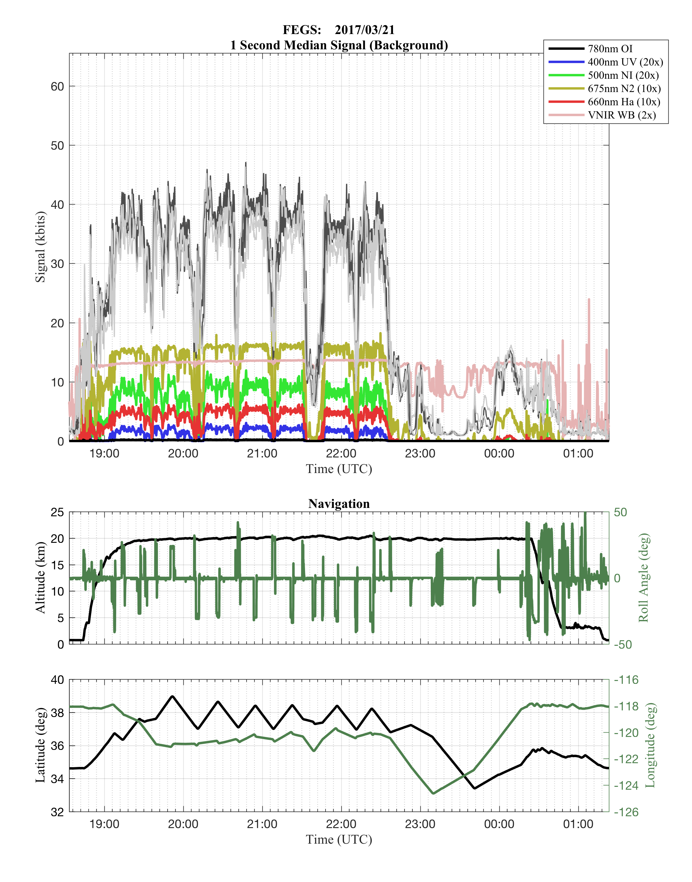
GOES-R PLT Fly's Eye GLM Simulator (FEGS) V1
National Aeronautics and Space Administration —
The GOES-R PLT Fly’s Eye GLM Simulator (FEGS) dataset consists of lightning flash, lightning pulse, and radiance data collected by the FEGS flown aboard a NASA ER-2... -
Federal
ECOSTRESS Tiled Evapotranspiration Instantaneous and Daytime L3 Global 70 m V002
National Aeronautics and Space Administration —
The ECOsystem Spaceborne Thermal Radiometer Experiment on Space Station (ECOSTRESS) mission measures the temperature of plants to better understand how much water... -
Federal
Ecosystem Functional Type Distribution Map for the Conterminous USA, 2001-2014
National Aeronautics and Space Administration —
This dataset provides maps of the distribution of ecosystem functional types (EFTs) and the interannual variability of EFTs at 0.05 degree resolution across the... -
Federal
Global Soil Profile Data (ISRIC-WISE)
National Aeronautics and Space Administration —
The International Soil Reference and Information Centre-World Inventory of Soil Emission Potentials (ISRIC-WISE) international soil profile data set consists of a... -
Federal
Data from: Draft Genome Assembly of Passalora sequoiae a Needle Blight Pathogen on Leyland Cypress
Department of Agriculture —
The objective was to generate a high-quality draft assembly of the whole genome as a resource for future applications such as temporal and spatial dispersal studies... -
Federal
NOAA/WDS Paleoclimatology - Brown fire data from Archuleta Mesa Plot B35 - IMPD USACH016
National Oceanic and Atmospheric Administration, Department of Commerce —
This archived Paleoclimatology Study is available from the NOAA National Centers for Environmental Information (NCEI), under the World Data Service (WDS) for...
267 datasets found for "77n주식디비@텔레그램RADARDB-"