

129 datasets found for "1 100000"
-
Federal
Dynamically Downscaled Hourly Future Weather Data with 12-km Resolution Covering Most of North America
Department of Energy —
This is an hourly future weather dataset for energy modeling applications. The dataset is primarily based on the output of a regional climate model (RCM), i.e., the... -
Federal
The Urban Energy-Water Nexus: Utility-Level Water Flows and Embedded Energy
Department of Energy —
There are limited open source data available for determining water production/treatment and required energy for cities across the United States. This database... -
Federal
Locale - Current
Department of Education —
This data layer produced by the National Center for Education Statistics’ (NCES) Education Demographic and Geographic Estimates (EDGE) program provides a geographic... -
Federal
Locales 2020
Department of Education —
This data layer produced by the National Center for Education Statistics’ (NCES) Education Demographic and Geographic Estimates (EDGE) program provides a geographic... -
Federal
3D shape and size data for 10084 and 14163 lunar regolith particles
National Institute of Standards and Technology —
This database contains 3D shape and size data for 10084 (Apollo 11) and 14163 (Apollo 14) real lunar regolith particles, along with STL files for the approximately... -
Federal
Near-Real Time Surface Ocean Velocity, Puerto Rico and the Virgin Islands, 2km Resolution, 2025-present
National Oceanic and Atmospheric Administration, Department of Commerce —
Surface ocean velocities estimated from High Frequency (HF)-Radar are representative of the upper 1.0 meters of the ocean. The main objective of near-real time... -
Federal
Locales 2016
Department of Education —
This data layer produced by the National Center for Education Statistics’ (NCES) Education Demographic and Geographic Estimates (EDGE) program provides a geographic... -
Federal
Locales 2021
Department of Education —
This data layer produced by the National Center for Education Statistics’ (NCES) Education Demographic and Geographic Estimates (EDGE) program provides a geographic... -
Federal
Locales 2015
Department of Education —
This data layer produced by the National Center for Education Statistics’ (NCES) Education Demographic and Geographic Estimates (EDGE) program provides a geographic... -
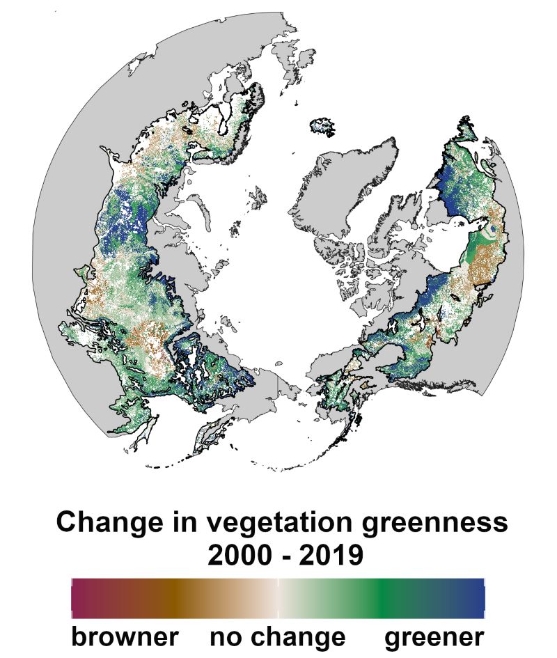
Federal
ABoVE: Landsat Vegetation Greenness Trends, Boreal Forest Biome, 1985-2019
National Aeronautics and Space Administration —
This dataset provides information on interannual trends in annual maximum vegetation greenness from 1985 to 2019 for recently undisturbed areas in the boreal forest... -
Federal
NSF Conference Report
National Science Foundation —
OMB Memorandum M-12-12 requires federal agencies to report by January 31st of each year, information on all agency-sponsored conferences from the previous year where... -
Federal
Locales 2017
Department of Education —
This data layer produced by the National Center for Education Statistics’ (NCES) Education Demographic and Geographic Estimates (EDGE) program provides a geographic... -
Federal
2020 Cartographic Boundary File (SHP), 2020 Public Use Microdata Areas for North Carolina, 1:500,000
U.S. Census Bureau, Department of Commerce —
The 2020 cartographic boundary shapefiles are simplified representations of selected geographic areas from the U.S. Census Bureau's Master Address File /... -
Federal
2020 Cartographic Boundary File (SHP), 2020 Public Use Microdata Areas for Massachusetts, 1:500,000
U.S. Census Bureau, Department of Commerce —
The 2020 cartographic boundary shapefiles are simplified representations of selected geographic areas from the U.S. Census Bureau's Master Address File /... -
Federal
2020 Cartographic Boundary File (KML), 2020 Public Use Microdata Areas for New Jersey, 1:500,000
U.S. Census Bureau, Department of Commerce —
The 2020 cartographic boundary KMLs are simplified representations of selected geographic areas from the U.S. Census Bureau's Master Address File / Topologically... -
Federal
2020 Cartographic Boundary File (SHP), Current New England City and Town Area (NECTA) Division for United States, 1:500,000
U.S. Census Bureau, Department of Commerce —
The 2020 cartographic boundary shapefiles are simplified representations of selected geographic areas from the U.S. Census Bureau's Master Address File /... -
Federal
2020 Cartographic Boundary File (KML), Current New England City and Town Area (NECTA) Division for United States, 1:500,000
U.S. Census Bureau, Department of Commerce —
The 2020 cartographic boundary KMLs are simplified representations of selected geographic areas from the U.S. Census Bureau's Master Address File / Topologically... -
Federal
2020 Cartographic Boundary File (SHP), 2020 Public Use Microdata Areas for United States, 1:500,000
U.S. Census Bureau, Department of Commerce —
The 2020 cartographic boundary shapefiles are simplified representations of selected geographic areas from the U.S. Census Bureau's Master Address File /... -
Federal
2020 Cartographic Boundary File (SHP), 2020 Public Use Microdata Areas for Mississippi, 1:500,000
U.S. Census Bureau, Department of Commerce —
The 2020 cartographic boundary shapefiles are simplified representations of selected geographic areas from the U.S. Census Bureau's Master Address File /...
129 datasets found for "1 100000"