
-
Federal
NLDAS Secondary Forcing Data L4 Hourly 0.125 x 0.125 degree V2.0 (NLDAS_FORB0125_H) at GES DISC recent views
National Aeronautics and Space Administration —
This data set contains the secondary forcing hourly data "File B" for Phase 2 of the North American Land Data Assimilation System (NLDAS-2). The data are in 1/8th... -
Federal
Hydrometeorological Automated Data System (HADS) SHEF-encoded Data recent views
National Oceanic and Atmospheric Administration, Department of Commerce —
HADS is a real-time and near real-time data acquisition, processing, and distribution system operated by the National Weather Service Office of Dissemination. The... -
Federal
Quality Controlled Local Climatological Data (QCLCD) Publication recent views
National Oceanic and Atmospheric Administration, Department of Commerce —
Quality Controlled Local Climatological Data (QCLCD) contains summaries from major airport weather stations that include a daily account of temperature extremes,... -
Federal
Monthly Summaries of the Global Historical Climatology Network - Daily (GHCN-D) recent views
National Oceanic and Atmospheric Administration, Department of Commerce —
Monthly Summaries of Global Historical Climatology Network (GHCN)-Daily is a dataset derived from GHCN-Daily. The data are produced by computing simple averages or... -
Federal
MISR Level 3 Component Global Aerosol Product covering a month V004 recent views
National Aeronautics and Space Administration —
MIL3MAE_4 is the Multi-angle Imaging SpectroRadiometer (MISR) Level 3 Component Global Aerosol Product covering a month version 4. It contains a statistical summary... -
Federal
CERES Energy Balanced and Filled (EBAF) TOA Monthly means data in netCDF Edition4.2 recent views
National Aeronautics and Space Administration —
CERES_EBAF-TOA_Edition4.2 is the Clouds and the Earth's Radiant Energy System (CERES) Energy Balanced and Filled (EBAF) Top-of-Atmosphere (TOA) Monthly means data in... -
Federal
Aqua/AIRS L2 Standard Physical Retrieval (AIRS+AMSU) V7.0 at GES DISC recent views
National Aeronautics and Space Administration —
The Atmospheric Infrared Sounder (AIRS) is a grating spectrometer (R = 1200) aboard the second Earth Observing System (EOS) polar-orbiting platform, EOS Aqua. The... -
Federal
OCO-2 GEOS Level 3 daily, 0.5x0.625 assimilated CO2 V10r (OCO2_GEOS_L3CO2_DAY) at GES DISC recent views
National Aeronautics and Space Administration —
This is the Gridded Daily OCO-2 Carbon Dioxide assimilated dataset. The OCO-2 mission provides the highest quality space-based XCO2 retrievals to date. However, the... -
Federal
NOAA Climate Data Record (CDR) of Ocean Near Surface Atmospheric Properties, Version 2 recent views
National Oceanic and Atmospheric Administration, Department of Commerce —
The NOAA Ocean Surface Bundle (OSB) Climate Data Record (CDR) consist of three parts: sea surface temperature; near-surface wind speed, air temperature, and specific... -
Federal
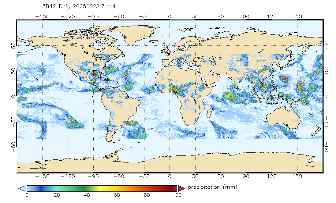
TRMM (TMPA) Precipitation L3 1 day 0.25 degree x 0.25 degree V7 (TRMM_3B42_Daily) at GES DISC recent views
National Aeronautics and Space Administration —
TMPA (3B42_Daily) dataset have been discontinued as of Dec. 31, 2019, and users are strongly encouraged to shift to the successor IMERG dataset (doi:... -
Federal
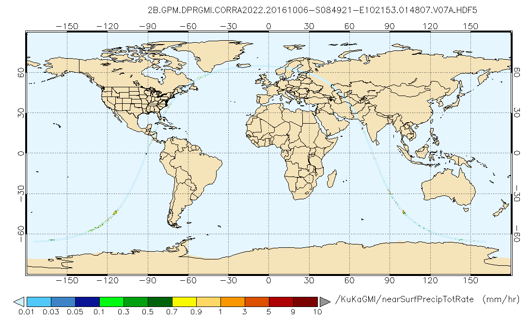
GPM DPR and GMI Combined Precipitation L2B 1.5 hours 5 km V07 (GPM_2BCMB) at GES DISC recent views
National Aeronautics and Space Administration —
Version 07 is the current version of the data set. Older versions will no longer be available and have been superseded by Version 07. This is a precipitation product... -
Federal
Daymet: Daily Surface Weather Data on a 1-km Grid for North America, Version 4 R1 recent views
National Aeronautics and Space Administration —
This dataset provides Daymet Version 4 R1 data as gridded estimates of daily weather parameters for North America, Hawaii, and Puerto Rico. Daymet variables include... -
Federal
Global Forecast System (GFS) [0.5 Deg.] recent views
National Oceanic and Atmospheric Administration, Department of Commerce —
The Global Forecast System (GFS) is a weather forecast model produced by the National Centers for Environmental Prediction (NCEP). Dozens of atmospheric and land-soil... -
Federal
U.S. Hourly Climate Normals (1981-2010) recent views
National Oceanic and Atmospheric Administration, Department of Commerce —
The U.S. Hourly Climate Normals for 1981 to 2010 are 30-year averages of meteorological parameters for thousands of U.S. stations located across the 50 states, as... -
Federal
Energy Data Exchange recent views
Department of Energy —
EDX is the Department of Energy (DOE)/Fossil Energy Carbon Management (FECM) virtual library and data laboratory built to find, connect, curate, use and re-use data... -
Federal
MISR Level 3 Component Global Land Product covering a year V004 recent views
National Aeronautics and Space Administration —
MIL3YLS_4 is the Multi-angle Imaging SpectroRadiometer (MISR) Level 3 Component Global Land Product covering a year version 4. It contains a statistical summary of... -
Federal
Topography, NOAA Coastal Relief Model, 3 arc second, Vol. 8 (Pacific Northwest), Lon0360 recent views
National Oceanic and Atmospheric Administration, Department of Commerce —
This Coastal Relief Gridded database provides the first comprehensive view of the US Coastal Zone; one that extends from the coastal state boundaries to as far... -
Federal
CALIPSO Lidar Level 2 5 km Aerosol Layer Data, V4-20 recent views
National Aeronautics and Space Administration —
CAL_LID_L2_05kmALay-Standard-V4-20 is the Cloud-Aerosol Lidar and Infrared Pathfinder Satellite Observation (CALIPSO) Lidar Level 2 5 km Aerosol Layer Data, Version... -
Federal
MODIS/Terra Aerosol Cloud Water Vapor Ozone Daily L3 Global 1Deg CMG NGDA recent views
National Aeronautics and Space Administration —
The MODIS/Terra Aerosol Cloud Water Vapor Ozone Daily L3 Global 1Deg CMG product (MOD08_D3) contains daily 1 x 1 degree grid average values of atmospheric parameters... -
Federal
Global Fire Emissions Database, Version 4.1 (GFEDv4) NGDA recent views
National Aeronautics and Space Administration —
This dataset provides global estimates of monthly burned area, monthly emissions and fractional contributions of different fire types, daily or 3-hourly fields to...

Official websites use .gov
A
.gov website belongs to an official government
organization in the United States.
Secure .gov websites use HTTPS
A
lock (
) or https:// means you’ve safely connected to
the .gov website. Share sensitive information only on official,
secure websites.