
-
Federal
Project HOTSPOT: Kimberly Well Borehole Geophysics Database recent views
Department of Energy —
The Snake River Plain (SRP), Idaho, hosts potential geothermal resources due to elevated groundwater temperatures associated with the thermal anomaly Yellowstone-... -
Federal
OCO-2 GEOS Level 3 daily, 0.5x0.625 assimilated CO2 V10r (OCO2_GEOS_L3CO2_DAY) at GES DISC recent views
National Aeronautics and Space Administration —
This is the Gridded Daily OCO-2 Carbon Dioxide assimilated dataset. The OCO-2 mission provides the highest quality space-based XCO2 retrievals to date. However, the... -
Federal
United States Utility-Scale PV Supply Curves 2023 recent views
Department of Energy —
This data packet contains supply curves, hourly generation profiles, and a composite siting exclusion TIFF for utility-scale PV across the contiguous United States.... -
Federal
Global Maps of Atmospheric Nitrogen Deposition, 1860, 1993, and 2050 recent views
National Aeronautics and Space Administration —
This data set provides global gridded estimates of atmospheric deposition of total inorganic nitrogen (N), NHx (NH3 and NH4+), and NOy (all oxidized forms of nitrogen... -
Federal
NACP North American Forest Dynamics Project: Forest Disturbance and Regrowth Data recent views
National Aeronautics and Space Administration —
This data set provides the results of time-series analyses of Landsat imagery for 55 selected forested sites across the conterminous U.S.A. The output is a pair of... -
Federal
NACP Regional: National Greenhouse Gas Inventories and Aggregated Gridded Model Data recent views
National Aeronautics and Space Administration —
This data set provides two products that were derived from the recently published North American Carbon Program (NACP) Regional Synthesis 1-degree terrestrial... -
Federal
United States Land-based Wind Supply Curves 2023 recent views
Department of Energy —
This data packet contains supply curves, hourly generation profiles, and a composite siting exclusion TIFF for land-based wind across the contiguous United States.... -
Federal
GPM IMERG Final Precipitation L3 1 day 0.1 degree x 0.1 degree V07 (GPM_3IMERGDF) at GES DISC recent views
National Aeronautics and Space Administration —
Version 07 is the current version of the data set. Older versions will no longer be available and have been superseded by Version 07. The Integrated Multi-satellitE... -
Federal
NOAA/WDS Paleoclimatology - Grissino-Mayer fire data from La Marchanita - IMPD USLAM001 recent views
National Oceanic and Atmospheric Administration, Department of Commerce —
This archived Paleoclimatology Study is available from the NOAA National Centers for Environmental Information (NCEI), under the World Data Service (WDS) for... -
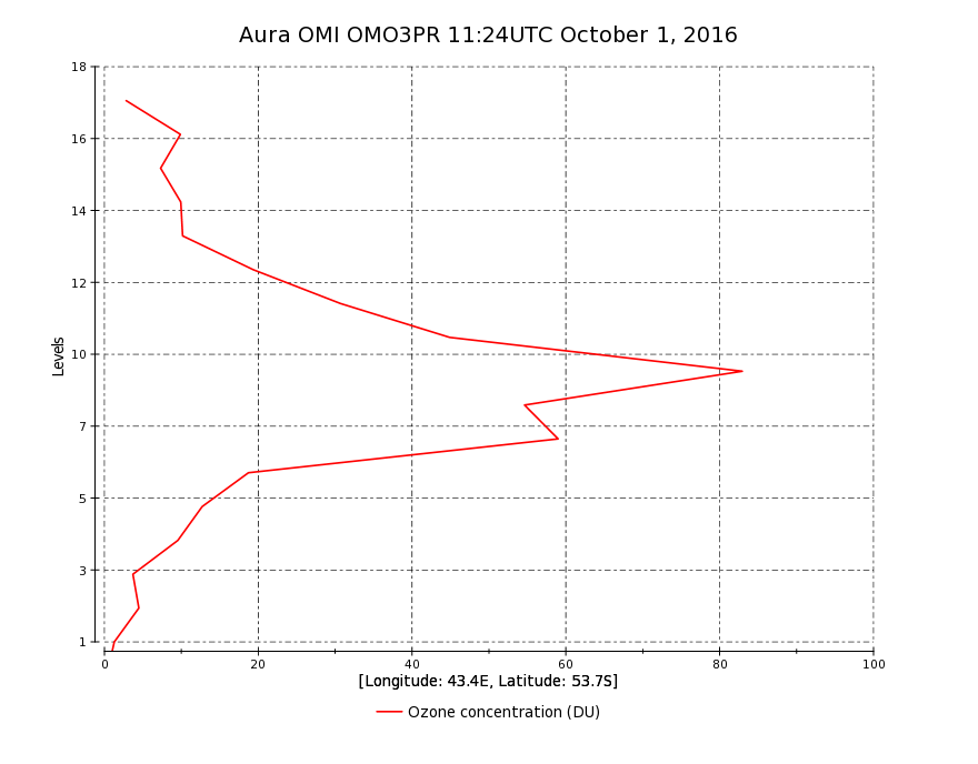
Federal
OMI/Aura Ozone (O3) Profile 1-Orbit L2 Swath 13x48km V003 (OMO3PR) at GES DISC recent views
National Aeronautics and Space Administration —
The Aura Ozone Monitoring Instrument Level-2 Ozone Profile data product OMO3PR (Version 003) is now available from the NASA Goddard Earth Sciences Data and... -
Federal
MERRA-2 tavg1_2d_aer_Nx: 2d,1-Hourly,Time-averaged,Single-Level,Assimilation,Aerosol Diagnostics 0.625 x 0.5 degree V5.12.4 (M2T1NXAER) at GES DISC recent views
National Aeronautics and Space Administration —
M2T1NXAER (or tavg1_2d_aer_Nx) is an hourly time-averaged 2-dimensional data collection in Modern-Era Retrospective analysis for Research and Applications version 2... -
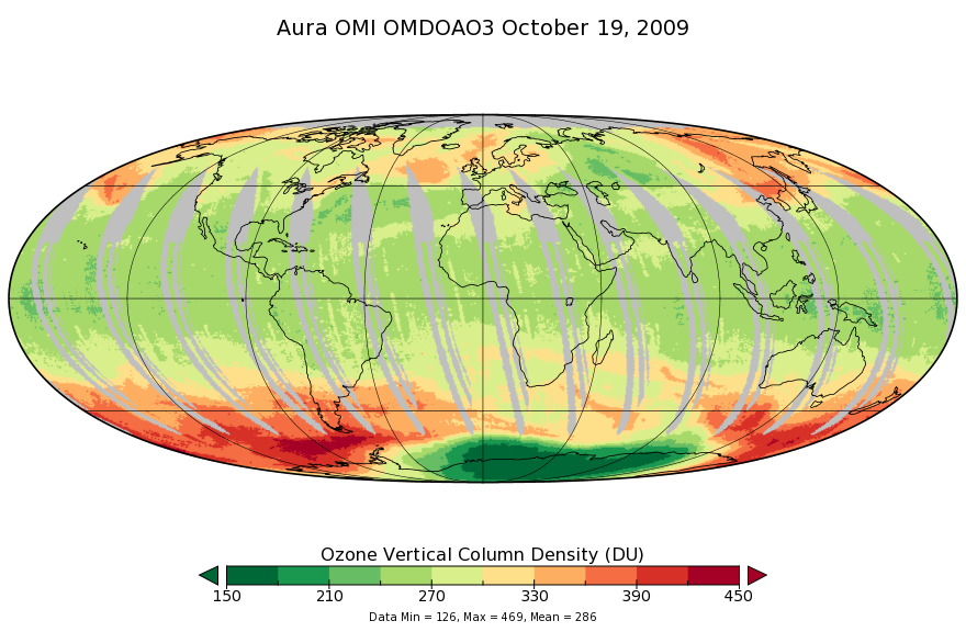
Federal
OMI/Aura Ozone (O3) DOAS Total Column Daily L3 1 day 0.25 degree x 0.25 degree V3 (OMDOAO3e) at GES DISC recent views
National Aeronautics and Space Administration —
The OMI science team produces this Level-3 Aura/OMI Global OMDOAO3e Data Products (0.25deg Lat/Lon grids). This Level-3 global total column ozone product is derived... -
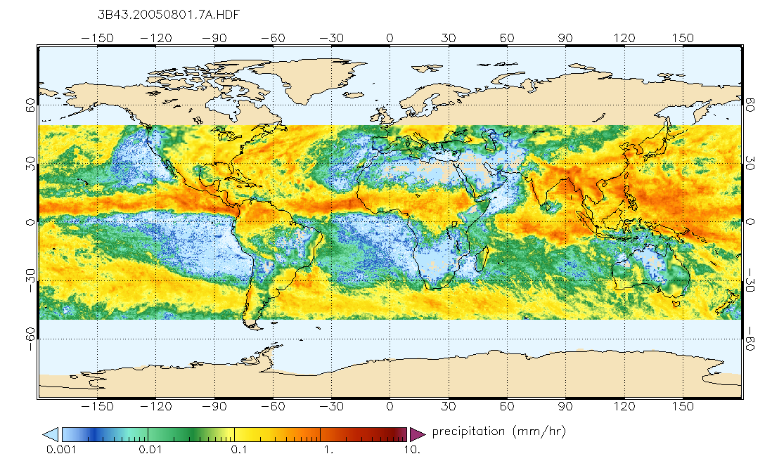
Federal
TRMM (TMPA/3B43) Rainfall Estimate L3 1 month 0.25 degree x 0.25 degree V7 (TRMM_3B43) at GES DISC recent views
National Aeronautics and Space Administration —
TMPA (3B43) dataset have been discontinued as of Dec. 31, 2019, and users are strongly encouraged to shift to the successor IMERG dataset (doi:... -
Federal
IRIS/Nimbus-4 Level 1 Radiance Data V001 (IRISN4RAD) at GES DISC recent views
National Aeronautics and Space Administration —
The Nimbus-4 Infrared Interferometer Spectrometer (IRIS) Level 1 Radiance Data contain thermal emissions of the Earth's atmosphere at wave numbers between 400 and... -
Federal
CALIPSO Lidar Level 2 Vertical Feature Mask (VFM), V4-51 recent views
National Aeronautics and Space Administration —
CAL_LID_L2_VFM-Standard-V4-21 is the Cloud-Aerosol Lidar and Infrared Pathfinder Satellite Observations (CALIPSO) Lidar Level 2 Vertical Feature Mask (VFM), Version... -
Federal
GLDAS Noah Land Surface Model L4 3 hourly 0.25 x 0.25 degree V2.0 (GLDAS_NOAH025_3H) at GES DISC recent views
National Aeronautics and Space Administration —
NASA Global Land Data Assimilation System Version 2 (GLDAS-2) has three components: GLDAS-2.0, GLDAS-2.1, and GLDAS-2.2. GLDAS-2.0 is forced entirely with the... -
Federal
GLDAS Catchment Land Surface Model L4 daily 0.25 x 0.25 degree GRACE-DA1 V2.2 (GLDAS_CLSM025_DA1_D) at GES DISC recent views
National Aeronautics and Space Administration —
NASA Global Land Data Assimilation System Version 2 (GLDAS-2) has three components: GLDAS-2.0, GLDAS-2.1, and GLDAS-2.2. GLDAS-2.0 is forced entirely with the... -
Federal
AMSR2/GCOM-W1 surface soil moisture (LPRM) L3 1 day 10 km x 10 km ascending V001 (LPRM_AMSR2_DS_A_SOILM3) at GES DISC recent views
National Aeronautics and Space Administration —
AMSR2/GCOM-W1 surface soil moisture (LPRM) L3 1 day 10 km x 10 km ascending V001 is a Level 3 (gridded) data set. Its land surface parameters, surface soil moisture,... -
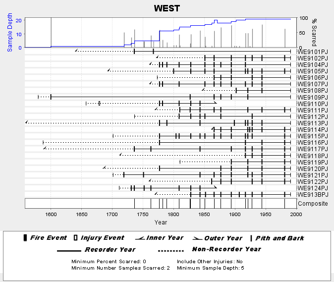
Federal
NOAA/WDS Paleoclimatology - Skinner fire data from WEST (San Pedro Martir) - IMPD MXWES001 recent views
National Oceanic and Atmospheric Administration, Department of Commerce —
This archived Paleoclimatology Study is available from the NOAA National Centers for Environmental Information (NCEI), under the World Data Service (WDS) for... -
Federal
TMI/TRMM surface soil moisture (LPRM) L2 V001 (LPRM_TMI_SOILM2) at GES DISC recent views
National Aeronautics and Space Administration —
TMI/TRMM surface soil moisture (LPRM) L2 V001 is a Level 2 (swath) data set. Its land surface parameters, surface soil moisture, land surface (skin) temperature, and...

Official websites use .gov
A
.gov website belongs to an official government
organization in the United States.
Secure .gov websites use HTTPS
A
lock (
) or https:// means you’ve safely connected to
the .gov website. Share sensitive information only on official,
secure websites.