
-
Federal
Georeferenced Population Datasets of Mexico (GEO-MEX): Urban Place GIS Coverage of Mexico recent views
National Aeronautics and Space Administration —
The Urban Place GIS Coverage of Mexico is a vector based point Geographic Information System (GIS) coverage of 696 urban places in Mexico. Each Urban Place is... -
Federal
China Dimensions Data Collection: China County-Level Data from Provincial Economic Yearbooks, Keyed to 1:1M GIS Map recent views
National Aeronautics and Space Administration —
The China County-Level Data on Provincial Economic Yearbooks, Keyed To 1:1M GIS Map consists of socioeconomic and boundary data for the administrative regions of... -
Federal
Georeferenced Population Datasets of Mexico (GEO-MEX): GIS of Mexican States, Municipalities and Islands recent views
National Aeronautics and Space Administration —
The GIS of Mexican States, Municipalities and Islands consists of attribute and boundary data for 1990. The attribute data include population, language, education,... -
Federal
China Dimensions Data Collection: China Administrative Regions GIS Data: 1:1M, County Level, 1990 recent views
National Aeronautics and Space Administration —
The China Administrative Regions GIS Data: 1:1M, County Level, 1990 consists of geographic boundary data for the administrative regions of China as of 31 December... -
Federal
2015 Urban Extents from VIIRS and MODIS for the Continental U.S. Using Machine Learning Methods NGDA recent views
National Aeronautics and Space Administration —
The 2015 Urban Extents from VIIRS and MODIS for the Continental U.S. Using Machine Learning Methods data set models urban settlements in the Continental United States... -
Federal
Georeferenced Population Datasets of Mexico (GEO-MEX): Raster Based GIS Coverage of Mexican Population recent views
National Aeronautics and Space Administration —
The Raster Based GIS Coverage of Mexican Population is a gridded coverage (1 x 1 km) of Mexican population. The data were converted from vector into raster. The... -
Federal
Global Rural-Urban Mapping Project, Version 1 (GRUMPv1): Urban Extent Polygons, Revision 02 recent views
National Aeronautics and Space Administration —
The Global Rural-Urban Mapping Project, Version 1 (GRUMPv1): Urban Extent Polygons, Revision 02 is an update to Revision 01, which included new settlements and... -
Federal
Snowchange Oral History - Work Among the Kolyma River Indigenous Societies in Siberia, Russia, Version 1 recent views
National Aeronautics and Space Administration —
This data set includes oral history accounts from Indigenous people participating in the Snowchange project in Siberia, Russia. It provides geographic and... -
Federal
Gridded Population of the World, Version 3 (GPWv3): National Identifier Grid recent views
National Aeronautics and Space Administration —
The Gridded Population of the World, Version 3 (GPWv3): National Identifier Grid is derived from the land area grid to create a raster surface where pixels (cells)... -
Federal
Global Rural-Urban Mapping Project, Version 1 (GRUMPv1): Urban Extents Grid recent views
National Aeronautics and Space Administration —
The Global Rural-Urban Mapping Project, Version 1 (GRUMPv1): Urban Extents Grid distinguishes urban and rural areas based on a combination of population counts... -
Federal
China Dimensions Data Collection: GuoBiao (GB) Codes for the Administrative Divisions of the Peoples Republic of China recent views
National Aeronautics and Space Administration —
The GuoBiao (GB) Codes for the Administrative Divisions of the People's Republic of China consists of geographic codes for the administrative divisions of China. The... -
Federal
1:100,000-scale Digital Line Graphs (DLG) from the U.S. Geological Survey recent views
National Aeronautics and Space Administration —
Digital line graph (DLG) data are digital representations of cartographic information. DLG's of map features are converted to digital form from maps and related... -
Federal
Archive of Census Related Products (ACRP): 1992 Boundary Files recent views
National Aeronautics and Space Administration —
The 1992 Boundary Files portion of the Archive of Census Related Products (ACRP) consists of 1992 boundary data from the U.S. Census Bureau's Topologically Integrated... -
Federal
LBA-ECO LC-01 Topographic Data for Intensive Study Areas, Northern Ecuadorian Amazon recent views
National Aeronautics and Space Administration —
This data set contains topographic/geomorphological data associated with the four Intensive Study Areas (ISAs) in the Northern Ecuadorian Amazon (northern Oriente)... -
Federal
Gazetteer of Planetary Nomenclature: Mars: MOLA global images recent views
National Aeronautics and Space Administration —
These maps display regional feature names and boundaries of regional features of Mars approved by the International Astronomical Union (IAU). -
Federal
LBA-ECO CD-06 Physical, Political, and Hydrologic Maps, Ji-Parana River Basin, Brazil recent views
National Aeronautics and Space Administration —
This data set contains physical, hydrologic, political, demographic, and societal maps for the Ji-Parana River Basin, in the state of Rondonia, Brazil. These data... -
Federal
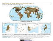
Gridded Population of the World, Version 4 (GPWv4): Administrative Unit Center Points with Population Estimates, Revision 11 recent views
National Aeronautics and Space Administration —
The Gridded Population of the World, Version 4 (GPWv4): Administrative Unit Center Points with Population Estimates, Revision 11 consists of UN WPP-adjusted... -
Federal
RLC State and Regional Boundaries for the Former Soviet Union recent views
National Aeronautics and Space Administration —
This data set of state and regional boundaries was derived from the 1:3 million scale administrative boundaries (ESRI, 1998) for the land area of the Former Soviet... -
Federal
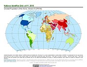
Gridded Population of the World, Version 4 (GPWv4): National Identifier Grid, Revision 11 recent views
National Aeronautics and Space Administration —
The Gridded Population of the World, Version 4 (GPWv4): National Identifier Grid, Revision 11 is a raster representation of nation-states in GPWv4 for use in... -
Federal
Gridded Population of the World, Version 3 (GPWv3): National Administrative Boundaries recent views
National Aeronautics and Space Administration —
The Gridded Population of the World, Version 3 (GPWv3): National Administrative Boundaries are derived from the land area grid to show the outlines of pixels (cells)...

Official websites use .gov
A
.gov website belongs to an official government
organization in the United States.
Secure .gov websites use HTTPS
A
lock (
) or https:// means you’ve safely connected to
the .gov website. Share sensitive information only on official,
secure websites.