
-
Federal
Sentinel-5P TROPOMI Tropospheric NO2 1-Orbit L2 7km x 3.5km V1 (S5P_L2__NO2___) at GES DISC
National Aeronautics and Space Administration —
Starting from August 6th in 2019, Sentinel-5P TROPOMI along-track high spatial resolution (~5.5km at nadir) has been implemented. For data after August 6th of 2019,... -
Federal
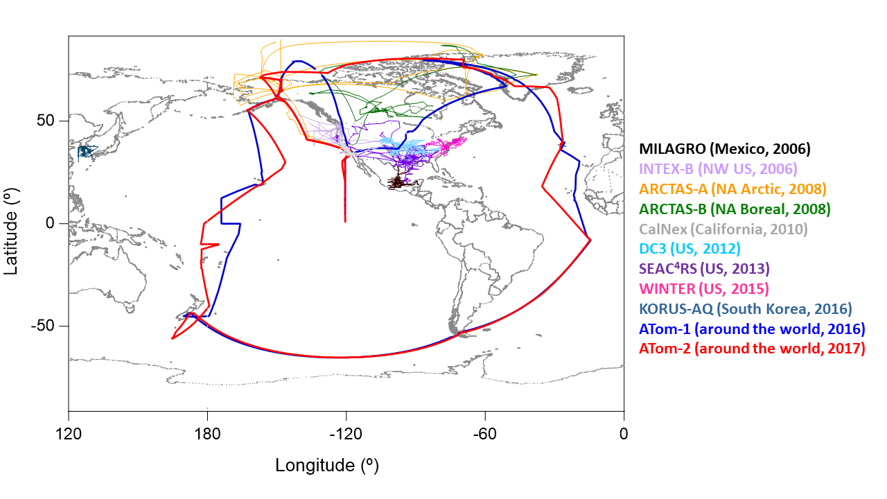
ATom: Dominant Role of Mineral Dust in Cirrus Cloud Formation
National Aeronautics and Space Administration —
This dataset provides: (1) In situ dust aerosol concentration measurements over remote tropical Pacific and Atlantic Oceans by NOAA Particle Analysis by Laser Mass... -
Federal
Pre-Delta-X: Total Suspended Solids of Surface Water across MRD, LA, USA, 2015-2016
National Aeronautics and Space Administration —
This dataset contains the total suspended solids (TSS) concentration of in situ water samples collected at selected sites across the Atchafalaya and Terrebonne Basins... -
Federal
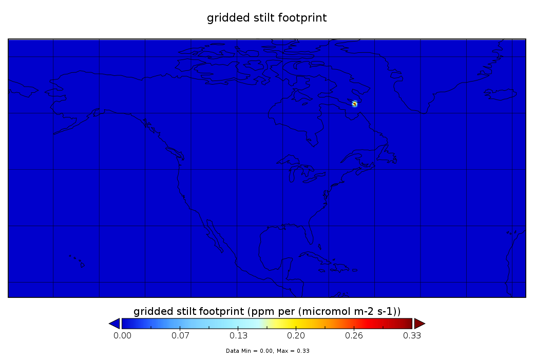
WRF-STILT Particle Trajectories for Boston, MA, USA, 2013-2014
National Aeronautics and Space Administration —
This dataset provides Weather Research and Forecasting (WRF) Stochastic Time-Inverted Lagrangian Transport (STILT) particle trajectory data and footprint products for... -
Federal
Global Maps of Atmospheric Nitrogen Deposition, 1860, 1993, and 2050
National Aeronautics and Space Administration —
This data set provides global gridded estimates of atmospheric deposition of total inorganic nitrogen (N), NHx (NH3 and NH4+), and NOy (all oxidized forms of nitrogen... -
Federal
Airborne Observations and Modeling Comparison of Global Inorganic Aerosol Acidity
National Aeronautics and Space Administration —
This dataset provides observations collected during eleven airborne campaigns from 2006–2017 and associated input and output from nine widely used chemical transport... -
Federal
CATS-ISS Level 2 Operational Day Mode 7.1 Version 3-01 5 km Layer
National Aeronautics and Space Administration —
CATS-ISS_L2O_D-M7.1-V3-01_05kmLay is the Cloud-Aerosol Transport System (CATS) International Space Station (ISS) Level 2 Operational Day Mode 7.1 Version 3-01 5 km... -
Federal
Delta-X: Bed and Suspended Sediment Grain Size, MRD, LA, USA, 2019-2021, V3
National Aeronautics and Space Administration —
This dataset includes sediment concentration and grain size distribution measurements from suspended and bed sediment samples collected in the Atchafalaya River and... -
Federal
SatCORPS CERES GEO Edition 4 MTSAT-2R Southern Hemisphere Version 1.2
National Aeronautics and Space Administration —
CER_GEO_Ed4_MTS02_SH_V01.2 is the Satellite Cloud and Radiation Property retrieval System (SatCORPS) Clouds and the Earth's Radiant Energy System (CERES)... -
Federal
CMS (Carbon Monitoring System) Methane (CH4) Flux for North America 0.5 degree x 0.667 degree V1 (CMS_CH4_FLX_NA) at GES DISC
National Aeronautics and Space Administration —
An error was found in this product; therefore, it has been deleted. Please use the CMS Methane (CH4) Flux for North America Daily product (CMS_CH4_FLX_NAD, DOI:... -
Federal
CMS: Global 0.5-deg Wetland Methane Emissions and Uncertainty (WetCHARTs v1.0)
National Aeronautics and Space Administration —
This data set provides global monthly wetland methane (CH4) emissions and uncertainty data products derived from an ensemble of multiple terrestrial biosphere models,... -
Federal
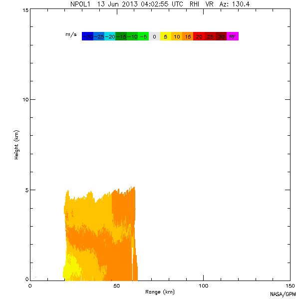
GPM GROUND VALIDATION NASA S-BAND DUAL POLARIMETRIC (NPOL) DOPPLER RADAR MC3E V1
National Aeronautics and Space Administration —
The GPM Ground Validation NASA S-band Dual Polarimetric (NPOL) Doppler Radar MC3E dataset was collected by the NASA NPOL radar, which was developed by a research team... -
Federal
CERES MODIS and GEO Cloud Retrievals in ISCCP-D2like Format Daytime Edition3A
National Aeronautics and Space Administration —
CER_ISCCP-D2like-Mrg_GEO-MODIS-DAY_Edition3A is the Clouds and the Earth's Radiant Energy System (CERES) Moderate Resolution Imaging Spectroradiometer (MODIS) and... -
Federal
ACT-America: L2 In Situ Atmospheric CO2, CO, CH4, and O3 Concentrations, Eastern USA
National Aeronautics and Space Administration —
This dataset provides atmospheric carbon dioxide (CO2), carbon monoxide (CO), methane (CH4), water vapor (H2O), and ozone (O3) concentrations collected during... -
Federal
CarbonTracker-Lagrange North America OCO-2 Vertical Profile of Footprints V1 (CMS_CTL_NA_OCO2_FOOTPRINTS)
National Aeronautics and Space Administration —
This data set provides Weather Research and Forecasting (WRF) Stochastic Time-Inverted Lagrangian Transport (STILT) particle trajectory data products for particle... -
Federal
GPM GROUND VALIDATION NASA S-BAND DUAL POLARIMETRIC (NPOL) DOPPLER RADAR IFLOODS V2
National Aeronautics and Space Administration —
The GPM Ground Validation NASA S-Band Dual Polarimetric (NPOL) Doppler Radar IFloodS dataset was collected from April 30 to June 16, 2013 near Traer, Iowa as part of... -
Federal
Vulcan: High-Resolution Hourly Fossil Fuel CO2 Emissions in USA, 2010-2015, Version 3
National Aeronautics and Space Administration —
The Vulcan version 3.0 hourly dataset quantifies hourly emissions at a 1-km resolution for the 2010-2015 time period. Estimates are provided of hourly carbon dioxide... -
Federal
Pre-LBA ABLE-2A and ABLE-2B Expedition Data
National Aeronautics and Space Administration —
The ABLE 2A and 2B (Atmospheric Boundary Layer Experiments) data consists of estimates of the rate of exchange of a wide variety of aerosols and gases between the... -
Federal
LBA-ECO LC-13 GIS Coverages of Logged Areas, Tapajos Forest, Para, Brazil: 1996, 1998
National Aeronautics and Space Administration —
We combined a detailed field study of canopy gap fraction with spectral mixture analysis of Landsat ETM+ satellite imagery to assess landscape and regional dynamics... -
Federal
STAQS NASA G-III GEOstationary Coastal and Air Pollution Events (GEO-CAPE) Airborne Simulator Data
National Aeronautics and Space Administration —
STAQS_AircraftRemoteSensing_NASA-G3_GCAS_Data is the remotely sensed trace gas data for the NASA Gulfstream III aircraft taken by the GEOstationary Coastal and Air...

Official websites use .gov
A
.gov website belongs to an official government
organization in the United States.
Secure .gov websites use HTTPS
A
lock (
) or https:// means you’ve safely connected to
the .gov website. Share sensitive information only on official,
secure websites.