
-
Federal
CYGNSS Level 3 Ocean Microplastic Concentration Version 3.2
National Aeronautics and Space Administration —
The CYGNSS L3 Ocean Microplastic Concentration V3.2 dataset is provided by the CYGNSS Science Team of the University of Michigan.CYGNSS was launched on 15 December... -
Federal
CYGNSS L3 Ocean Microplastic Concentration V1.0
National Aeronautics and Space Administration —
This dataset contains the version 1.0 CYGNSS level 3 ocean microplastic concentration data record, which provides 18 netCDF files, each containing one month of daily... -
Federal
SWOT Level 2 River Single-Pass Vector Data Product, Version D
National Aeronautics and Space Administration —
The SWOT Level 2 River Single-Pass Vector Data Product (SWOT_L2_HR_RiverSP_D) provides hydrologic measurements for predefined river reaches and nodes, derived from... -
Federal
Global Landslide Nowcast from LHASA L4 1 day 1 km x 1 km version 1.1 (Global_Landslide_Nowcast) at GES DISC
National Aeronautics and Space Administration —
The Landslide Hazard Assessment for Situational Awareness (LHASA) model identifies locations with high potential for landslide occurrence at a daily temporal... -
Federal
MODIS/Terra Land Water Mask Derived from MODIS and SRTM L3 Global 250m SIN Grid V006
National Aeronautics and Space Administration —
The MOD44W Version 6 data product was decommissioned on July 18, 2024. Users are encouraged to use the MOD44W Version 6.1 data product... -
Federal
Global Soil Types, 1-Degree Grid (Zobler)
National Aeronautics and Space Administration —
A global data set of soil types is available at 1-degree latitude by 1-degree longitude resolution. There are 26 soil units based on Zobler?s assessment of FAO Soil... -
Federal
SWOT Level 2 River Single-Pass Vector Data Product, Version 2.0
National Aeronautics and Space Administration —
The SWOT Level 2 River Single-Pass Vector Data Product from the Surface Water Ocean Topography (SWOT) mission provides water surface elevation, slope, width, and... -
Federal
CYGNSS Level 1 Science Data Record Version 2.1
National Aeronautics and Space Administration —
This Level 1 (L1) dataset contains the Version 2.1 geo-located Delay Doppler Maps (DDMs) calibrated into Power Received (Watts) and Bistatic Radar Cross Section... -
Federal
SWOT Level 2 River Single-Pass Vector Reach Data Product, Version 2.0
National Aeronautics and Space Administration —
The SWOT Level 2 River Single-Pass Vector Reach Data Product from the Surface Water Ocean Topography (SWOT) mission provides water surface elevation, slope, width,... -
Federal
CYGNSS Level 1 Science Data Record Version 3.2
National Aeronautics and Space Administration —
This CYGNSS Level 1 (L1) science data record dataset contains the version 3.2 geo-located Delay Doppler Maps (DDMs) calibrated into Power Received (Watts) and... -
Federal
CAR ARMCAS Arctic Cloud Radiation Measurements L1 V1 (CAR_ARMCAS_L1C) at GES DISC
National Aeronautics and Space Administration —
The Arctic Radiation Measurement in Column Atmosphere-surface System (ARMCAS) was a collaborative research effort between the Cloud and Aerosol Research (CAR) Group,... -
Federal
Eddy Corr. Surface Flux: UK (FIFE)
National Aeronautics and Space Administration —
Surface flux measurements were made at selected sites within the FIFE study area. Each surface flux station was capable of measuring the fluxes of net radiation,... -
Federal
Spectral Reflectance and Ancillary Data, Tundra Transect, North Slope, AK, 2000-2022
National Aeronautics and Space Administration —
This dataset provides visible-near infrared spectral reflectance, descriptions of vegetation cover, surface temperature, the total fraction of absorbed... -
Federal
NPP Tropical Forest: Cinnamon Bay, U.S. Virgin Islands, 1982-1993, R1
National Aeronautics and Space Administration —
This data set contains three ASCII files (.txt format). One data file contains above-ground biomass, litter, litterfall, herbivory, biomass change, and above-ground... -
Federal
Aboveground Biomass Density for High Latitude Forests from ICESat-2, 2020
National Aeronautics and Space Administration —
This dataset provides estimates of Aboveground dry woody Biomass Density (AGBD) for high northern latitude forests at a 30-m spatial resolution. It is designed both... -
Federal
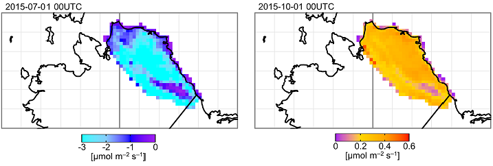
ABoVE: TVPRM Simulated Net Ecosystem Exchange, Alaskan North Slope, 2008-2017
National Aeronautics and Space Administration —
This dataset includes hourly net ecosystem exchange (NEE) simulated by the Tundra Vegetation Photosynthesis and Respiration Model (TVPRM) at 30 km horizontal... -
Federal
CYGNSS Level 1 Climate Data Record Version 1.0
National Aeronautics and Space Administration —
This Level 1 (L1) dataset contains the Version 1.0 Climate Data Record (CDR) of the geo-located Delay Doppler Maps (DDMs) calibrated into Power Received (Watts) and... -
Federal
SWOT Level 2 Water Mask Pixel Cloud Auxiliary Data Product, Version D
National Aeronautics and Space Administration —
The SWOT Level 2 Water Mask Pixel Cloud Auxiliary Data Product (SWOT_L2_HR_PIXCVec_D) provides per-feature attributes for surface water bodies identified from the Ka-...

Official websites use .gov
A
.gov website belongs to an official government
organization in the United States.
Secure .gov websites use HTTPS
A
lock (
) or https:// means you’ve safely connected to
the .gov website. Share sensitive information only on official,
secure websites.