
-
Federal
Milky Way Star Clusters Catalog
National Aeronautics and Space Administration —
Although they are the main constituents of the Galactic disk population, for half of the open clusters in the Milky Way reported in the literature nothing is known... -
Federal
Gridded Population of the World, Version 4 (GPWv4): Population Density, Revision 11
National Aeronautics and Space Administration —
The Gridded Population of the World, Version 4 (GPWv4): Population Density, Revision 11 consists of estimates of human population density (number of persons per... -
Federal
Last of the Wild Project, Version 2, 2005 (LWP-2): Global Human Footprint Dataset (Geographic)
National Aeronautics and Space Administration —
The Global Human Footprint Dataset of the Last of the Wild Project, Version 2, 2005 (LWP-2) is the Human Influence Index (HII) normalized by biome and realm. The HII... -
Federal
Global Population Density Grid Time Series Estimates
National Aeronautics and Space Administration —
The Global Population Density Grid Time Series Estimates provide a back-cast time series of population density grids based on the year 2000 population grid from... -
Federal
Global Fertilizer and Manure, Version 1: Nitrogen in Manure Production
National Aeronautics and Space Administration —
The Nitrogen in Manure Production data set of the Global Fertilizer and Manure, Version 1 Data Collection represents the amount of nitrogen manure produced and... -
Federal
Low Elevation Coastal Zone (LECZ) Global Delta Urban-Rural Population and Land Area Estimates, Version 1
National Aeronautics and Space Administration —
The Low Elevation Coastal Zone (LECZ) Global Delta Urban-Rural Population and Land Area Estimates, Version 1 data set provides country-level estimates of urban,... -
Federal
Last of the Wild Project, Version 2, 2005 (LWP-2): Global Human Influence Index (HII) Dataset (Geographic)
National Aeronautics and Space Administration —
The Global Human Influence Index Dataset of the Last of the Wild Project, Version 2, 2005 (LWP-2) is a global dataset of 1-kilometer grid cells, created from nine... -
Federal
Global 15 x 15 Minute Grids of the Downscaled GDP Based on the SRES B2 Scenario, 1990 and 2025
National Aeronautics and Space Administration —
The Global 15x15 Minute Grids of the Downscaled GDP Based on the Special Report on Emissions Scenarios (SRES) B2 Scenario, 1990 and 2025, are geospatial distributions... -
Federal
Gridded Population of the World, Version 3 (GPWv3): Population Density Grid
National Aeronautics and Space Administration —
The Gridded Population of the World, Version 3 (GPWv3): Population Density Grid consists of estimates of human population for the years 1990, 1995, and 2000 by 2.5... -
Federal
Last of the Wild Project, Version 3 (LWP-3): 2009 Human Footprint, 2018 Release
National Aeronautics and Space Administration —
The 2009 Human Footprint, 2018 Release provides a global map of the cumulative human pressure on the environment in 2009, at a spatial resolution of ~1 km. The human... -
Federal
Global Rural-Urban Mapping Project, Version 1 (GRUMPv1): Land and Geographic Unit Area Grids
National Aeronautics and Space Administration —
The Global Rural-Urban Mapping Project, Version 1 (GRUMPv1): Land and Geographic Unit Area Grids measure land areas in square kilometers and the mean Unit size... -
Federal
Global Grid of Probabilities of Urban Expansion to 2030
National Aeronautics and Space Administration —
The Global Grid of Probabilities of Urban Expansion to 2030 presents spatially explicit probabilistic forecasts of global urban land cover change from 2000 to 2030 at... -
Federal
Global Fertilizer and Manure, Version 1: Phosphorus in Manure Production
National Aeronautics and Space Administration —
The Phosphorus in Manure Production data set of the Global Fertilizer and Manure, Version 1 Data Collection represents the amount of phosphorous in manure produced... -
Federal
Archive of Census Related Products (ACRP): 1990 Census Block Statistics
National Aeronautics and Space Administration —
The 1990 Census Block Statistics portion of the Archive of Census Related Products (ACRP) contains population and housing data from the U.S. Census Bureau's 1990... -
Federal
Global Land Cover Mapping and Estimation Yearly 30 m V001
National Aeronautics and Space Administration —
NASA's Making Earth System Data Records for Use in Research Environments (MEaSUREs) Global Land Cover Mapping and Estimation (GLanCE) annual 30 meter (m) Version 1... -
Federal
Gridded Population of the World, Version 4 (GPWv4): Basic Demographic Characteristics, Revision 11
National Aeronautics and Space Administration —
The Gridded Population of the World, Version 4 (GPWv4): Basic Demographic Characteristics, Revision 11 consists of estimates of human population by age and sex as... -
Federal
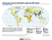
Anthropogenic Biomes of the World, Version 2: 2000
National Aeronautics and Space Administration —
The Anthropogenic Biomes of the World, Version 2: 2000 data set describes anthropogenic transformations within the terrestrial biosphere caused by sustained direct... -
Federal
Last of the Wild Project, Version 1, 2002 (LWP-1): Global Human Footprint Dataset (Geographic)
National Aeronautics and Space Administration —
The Global Human Footprint Dataset of the Last of the Wild Project, Version 1, 2002 (LWP-1) is the Human Influence Index (HII) normalized by biome and realm. The HII... -
Federal
National Aggregates of Geospatial Data Collection: Population, Landscape, And Climate Estimates, Version 3 (PLACE III)
National Aeronautics and Space Administration —
The National Aggregates of Geospatial Data Collection: Population, Landscape, And Climate Estimates, Version 3 (PLACE III) data set contains estimates of national-... -
Federal
Anthropogenic Biomes of the World, Version 2: 1700
National Aeronautics and Space Administration —
The Anthropogenic Biomes of the World, Version 2: 1700 data set describes anthropogenic transformations within the terrestrial biosphere caused by sustained direct...

Official websites use .gov
A
.gov website belongs to an official government
organization in the United States.
Secure .gov websites use HTTPS
A
lock (
) or https:// means you’ve safely connected to
the .gov website. Share sensitive information only on official,
secure websites.