
-
Federal
BOREAS/SRC AMS Suite A Surface Meteorological and Radiation Data: 1996
National Aeronautics and Space Administration —
Contains the data collected in 1996 by the AMS suite A instrument set operated by SRC and provided to BORIS. -
Federal
ABoVE: Monthly Hydrological Fluxes for Canada and Alaska, 1979-2018
National Aeronautics and Space Administration —
This dataset provides modeled estimates of monthly hydrological fluxes at 0.25-degree resolution over Alaska and Canada for the years 1979-2018. The estimates were... -
Federal
Alaska's Changing YK Delta: Knowledge Exchange between Elders and Geoscientists, 2018
National Aeronautics and Space Administration —
This dataset provides a booklet documenting the discussions and outcomes from a knowledge-exchange meeting with Yup'ik elders from the Yukon-Kuskokwim Delta (YKD),... -
Federal
BOREAS HYD-04 Standard Snow Course Data
National Aeronautics and Space Administration —
Contains the standard snow course data collected at various sites in the NSA and SSA by HYD-04. -
Federal
Arctic Vegetation Plots, Prudhoe Bay ArcSEES Road Study, Lake Colleen, Alaska, 2014
National Aeronautics and Space Administration —
This dataset provides environmental, soil, and vegetation data collected from study plots in the vicinity of Lake Colleen off the Spine Road at Prudhoe Bay, Alaska,... -
Federal
ABoVE: Rain-on-Snow Frequency and Distribution during Cold Seasons, Alaska, 2003-2016 NGDA
National Aeronautics and Space Administration —
This dataset provides maps of rain-on-snow (ROS) events across Alaska for the individual months of November to March 2002-2011 and November to March 2012-2016, and... -
Federal
ABoVE: Last Day of Spring Snow, Alaska, USA, and Yukon Territory, Canada, 2000-2016 NGDA
National Aeronautics and Space Administration —
This dataset provides the last day of spring snow cover for most of Alaska and the Yukon Territory for 2000 through 2016. The data are based on the MODIS daily snow... -
Federal
ABoVE: Passive Microwave-derived Annual Snowoff Date Maps, 1988-2018
National Aeronautics and Space Administration —
This dataset provides annual maps of the snowoff (SO) date from 1988-2018 across Alaska and parts of Far East Russia and northwest Canada at a resolution of 6.25 km.... -
Federal
BOREAS/SRC AMS Suite A Surface Meteorological and Radiation Data: 1994
National Aeronautics and Space Administration —
Contains the data collected in 1994 by the AMS suite A instrument set operated by SRC and provided to BORIS. -
Federal
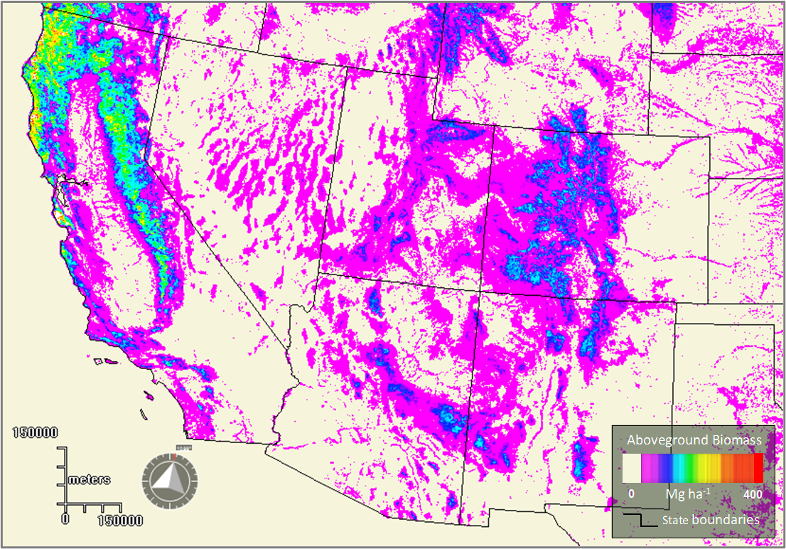
Forest Aboveground Biomass for the Southwestern U.S. from MISR, 2000-2021
National Aeronautics and Space Administration —
This dataset provides estimates of forest aboveground biomass (AGB; in Mg ha-1) at a resolution of 250 m for the southwestern United States over the time period... -
Federal
BOREAS HYD-03 Subcanopy Meteorological Data
National Aeronautics and Space Administration —
This table contains the sub-canopy meteorological data collected by HYD-3. -
Federal
ISLSCP II ECMWF Near-Surface Meteorology Parameters
National Aeronautics and Space Administration —
This data set for the ISLSCP Initiative II data collection provides meteorology data with fixed, monthly, monthly-6-hourly, 6-hourly, and 3-hourly temporal... -
Federal
ABoVE: High Resolution Cloud-Free Snow Cover Extent and Snow Depth, Alaska, 2001-2017 NGDA
National Aeronautics and Space Administration —
This dataset provides estimates of maximum snow cover extent (SCE) and snow depth for each 8-day composite period from 2001 to 2017 at 1 km resolution across Alaska.... -
Federal
ABoVE: Aerial Photographs of Frozen Lakes near Fairbanks, Alaska, October 2014
National Aeronautics and Space Administration —
This dataset includes high resolution orthophotographs of 21 lakes in the region of Fairbanks, Alaska, USA. Aerial photographs were taken on October 8, 2014, three... -
Federal
Maps of Vegetation, NDVI, Snow and Thaw Depths: North Slope, Alaska and NWT, Canada
National Aeronautics and Space Administration —
This dataset includes vegetation cover maps, Normalized Difference Vegetation Index (NDVI) maps, snow depth and thaw depth data that were obtained as part of a... -
Federal
ABoVE: Dall Sheep Track Sinking Depths, Snow Depth, Hardness, and Density, 2017
National Aeronautics and Space Administration —
This dataset contains Dall sheep (Ovis dalli dalli) hoof sinking depths in snow tracks, and snow depth, hardness, and density measurements in snow pits adjacent to... -
Federal
Pre-ABoVE: Ground-penetrating Radar Measurements of ALT on the Alaska North Slope
National Aeronautics and Space Administration —
This data set includes estimates of permafrost Active Layer Thickness (ALT; cm), and calculated uncertainties, derived using a ground-penetrating radar (GPR) system... -
Federal
ABoVE: Active Layer Thickness from Remote Sensing Permafrost Model, Alaska, 2001-2015 NGDA
National Aeronautics and Space Administration —
This dataset provides annual estimates of active layer thickness (ALT) at 1 km resolution across Alaska from 2001-2015. The ALT was estimated using a remote sensing-... -
Federal
ABoVE: CO2 and CH4 Fluxes and Meteorology at Flux Tower Sites, Alaska, 2015-2017
National Aeronautics and Space Administration —
This dataset provides CO2 and CH4 fluxes and meteorological parameters from five eddy covariance (EC) tower sites located at Barrow (three sites), Atqasuk (ATQ) and... -
Federal
BOREAS HYD-04 Areal Snow Course Survey Data
National Aeronautics and Space Administration —
Contains the areal snow survey data collected by HYD-04. The flight line numbers that are included correspond to the flight lines from HYD-06 measurements.

Official websites use .gov
A
.gov website belongs to an official government
organization in the United States.
Secure .gov websites use HTTPS
A
lock (
) or https:// means you’ve safely connected to
the .gov website. Share sensitive information only on official,
secure websites.