
-
Federal
VEMAP 2: Annual Ecosystem Model Responses to U.S. Climate Change, 1994-2100 recent views
National Aeronautics and Space Administration —
Phase 2 of the VEMAP Project developed historical (1895-1993) gridded data sets of climate (temperature, precipitation, solar radiation, humidity, and wind speed) and... -
Federal
ATom: Merged Atmospheric Chemistry, Trace Gases, and Aerosols recent views
National Aeronautics and Space Administration —
This dataset provides information on greenhouse gases and human-produced air pollution, including atmospheric concentrations of carbon dioxide (CO2), methane (CH4),... -
Federal
Global Forest Ecosystem Structure and Function Data For Carbon Balance Research recent views
National Aeronautics and Space Administration —
A comprehensive global database has been assembled to quantify CO2 fluxes and pathways across different levels of integration (from photosynthesis up to net ecosystem... -
Federal
ISLSCP II EDGAR 3 Gridded Greenhouse and Ozone Precursor Gas Emissions recent views
National Aeronautics and Space Administration —
The EDGAR (Emission Database for Global Atmospheric Research) database project is a comprehensive task carried out jointly by the National Institute for Public Health... -
Federal
Global Fire Emissions Database, Version 4.1 (GFEDv4) NGDA recent views
National Aeronautics and Space Administration —
This dataset provides global estimates of monthly burned area, monthly emissions and fractional contributions of different fire types, daily or 3-hourly fields to... -
Federal
Sources of Methane Emissions (Vista-CA), State of California, USA recent views
National Aeronautics and Space Administration —
This dataset provides spatial data products with identified and organized locations of potential methane (CH4) emitting facilities and infrastructure spanning the... -
Federal
A Global Database of Gas Fluxes from Soils after Rewetting or Thawing, Version 1.0 recent views
National Aeronautics and Space Administration —
This database contains information compiled from published studies on gas flux from soil following rewetting or thawing. The resulting database includes 222 field and... -
Federal
CMS: Global 0.5-deg Wetland Methane Emissions and Uncertainty (WetCHARTs v1.3.3) recent views
National Aeronautics and Space Administration —
This dataset provides global monthly wetland methane (CH4) emissions estimates at 0.5 by 0.5-degree resolution for the period 2001-01-01 to 2022-08-31 that were... -
Federal
Daymet: Daily Surface Weather Data on a 1-km Grid for North America, Version 4 R1 recent views
National Aeronautics and Space Administration —
This dataset provides Daymet Version 4 R1 data as gridded estimates of daily weather parameters for North America, Hawaii, and Puerto Rico. Daymet variables include... -
Federal
Global Maps of Atmospheric Nitrogen Deposition, 1860, 1993, and 2050 recent views
National Aeronautics and Space Administration —
This data set provides global gridded estimates of atmospheric deposition of total inorganic nitrogen (N), NHx (NH3 and NH4+), and NOy (all oxidized forms of nitrogen... -
Federal
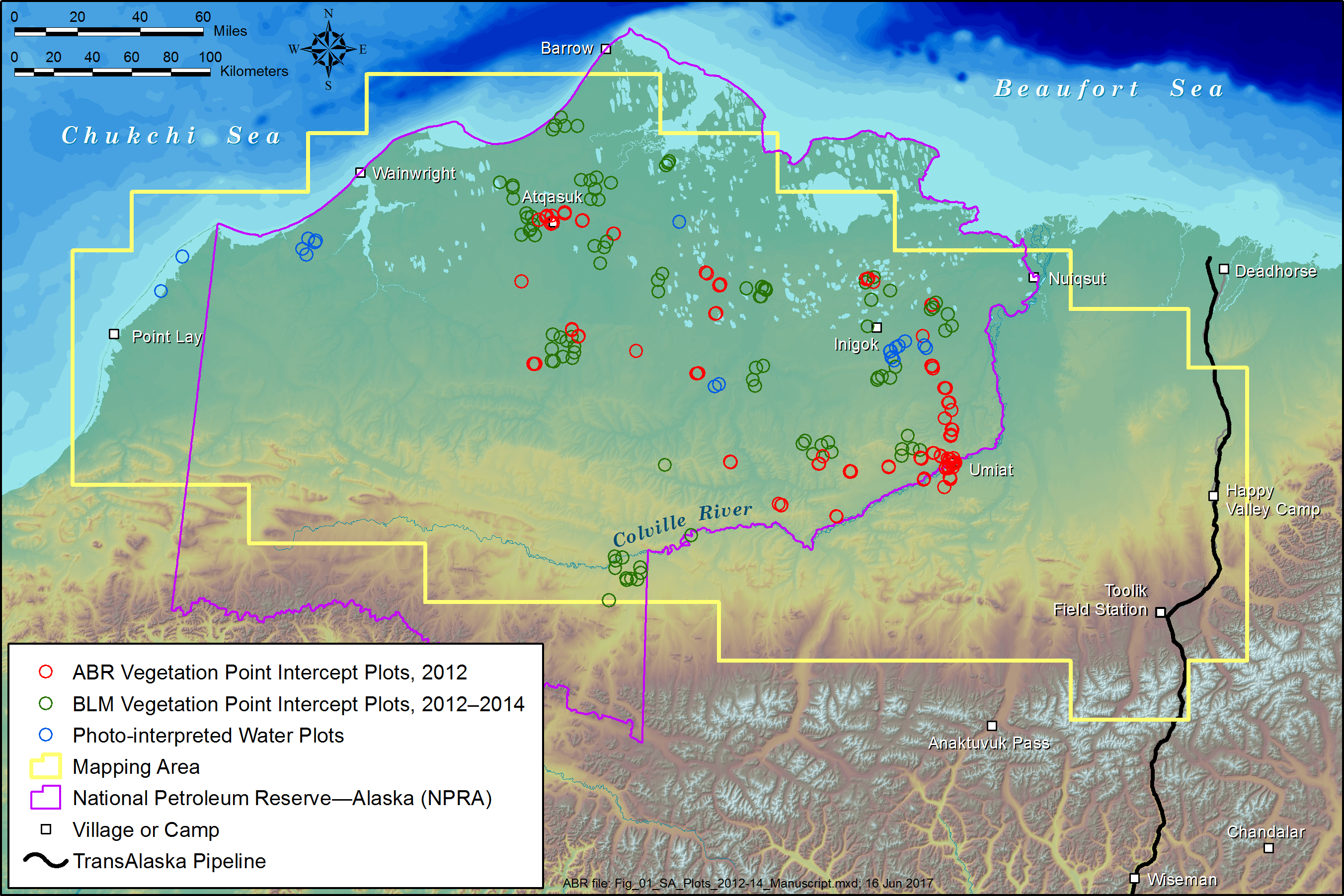
ABoVE: Tundra Plant Functional Type Continuous-Cover, North Slope, Alaska, 2010-2015 recent views
National Aeronautics and Space Administration —
This dataset provides predicted continuous-field cover for tundra plant functional types (PFTs), across ~125,000 km2 of Alaska's North Slope at 30-m resolution. The... -
Federal
ATom: Comprehensive Aerosol Properties, 2016-2018, Version 2 recent views
National Aeronautics and Space Administration —
This dataset contains comprehensive measurements of aerosol microphysical, chemical, and optical properties derived for both dry and ambient conditions from in situ... -
Federal
CARVE: L1 Spectral Radiances from Airborne FTS, Alaska, 2012-2015 recent views
National Aeronautics and Space Administration —
This data set contains Level 1 spectral radiance data collected using the Fourier Transform Spectrometer (FTS) during airborne campaigns over the Alaskan and Canadian... -
Federal
Pre-ABoVE: Particle Trajectories for WRF-STILT Model, Barrow, AK, 1982-2011 recent views
National Aeronautics and Space Administration —
This dataset provides Stochastic Time-Inverted Lagrangian Transport model outputs for receptors located at the NOAA Barrow Alaska Observatory for 12 selected years... -
Federal
Pre-ABoVE: Gridded Footprints from WRF-STILT Model, Barrow, Alaska, 1982-2011 recent views
National Aeronautics and Space Administration —
This dataset provides Stochastic Time-Inverted Lagrangian Transport model outputs for receptors located at the NOAA Barrow Alaska Observatory for 12 selected years... -
Federal
CARVE: L1 In-situ Carbon and CH4 Flux and Meteorology at EC Towers, Alaska, 2011-2015 recent views
National Aeronautics and Space Administration —
This data set provides ground in situ flux and meteorological science data from fixed instruments at three eddy covariance tower sites located in the Alaskan Arctic... -
Federal
ATom: Observed and GEOS-5 Simulated CO Concentrations with Tagged Tracers for ATom-1 recent views
National Aeronautics and Space Administration —
This dataset contains carbon monoxide (CO) observations at 10-second intervals from flights during the ATom-1 campaign in 2016 and simulated CO concentrations from... -
Federal
ACT-America: L2 Remotely Sensed Column-avg CO2 by Airborne Lidar, Lite, Eastern USA recent views
National Aeronautics and Space Administration —
This dataset provides a direct subset (i.e., the Lite version) of the Level 2 (L2) remotely sensed column-average carbon dioxide (CO2) concentrations measured during... -
Federal
Net Radiation and Albedo from MODIS for Xingu River Basin, Brazil, 2000-2012 NGDA recent views
National Aeronautics and Space Administration —
This dataset provides daily average land surface net radiation (Rnet) as an 8-day time series at approximately 0.5 km resolution for the upper Xingu River Basin in... -
Federal
NWS Daily Climatology Data: 1985 (SNF) recent views
National Aeronautics and Space Administration —
Daily min, max, average temperature (F), precipitation (water equivalent in inches), and daily insolation (Langleys) for the Superior National Forest area as...

Official websites use .gov
A
.gov website belongs to an official government
organization in the United States.
Secure .gov websites use HTTPS
A
lock (
) or https:// means you’ve safely connected to
the .gov website. Share sensitive information only on official,
secure websites.