ABoVE: Tundra Plant Functional Type Continuous-Cover, North Slope, Alaska, 2010-2015
Access & Use Information
Downloads & Resources
-
Google Scholar search resultsHTML
Search results for publications that cite this dataset by its DOI.
-
Download this datasetHTML
This link allows direct data access via Earthdata login
-
View documentation related to this datasetHTML
ORNL DAAC Data Set Documentation
-
This dataset's landing pageHTML
Data set Landing Page DOI URL
-
View documentation related to this datasetPDF
ABoVE: Tundra Plant Functional Type Continuous-Cover, North Slope, Alaska,...
-
Get a related visualizationPNG
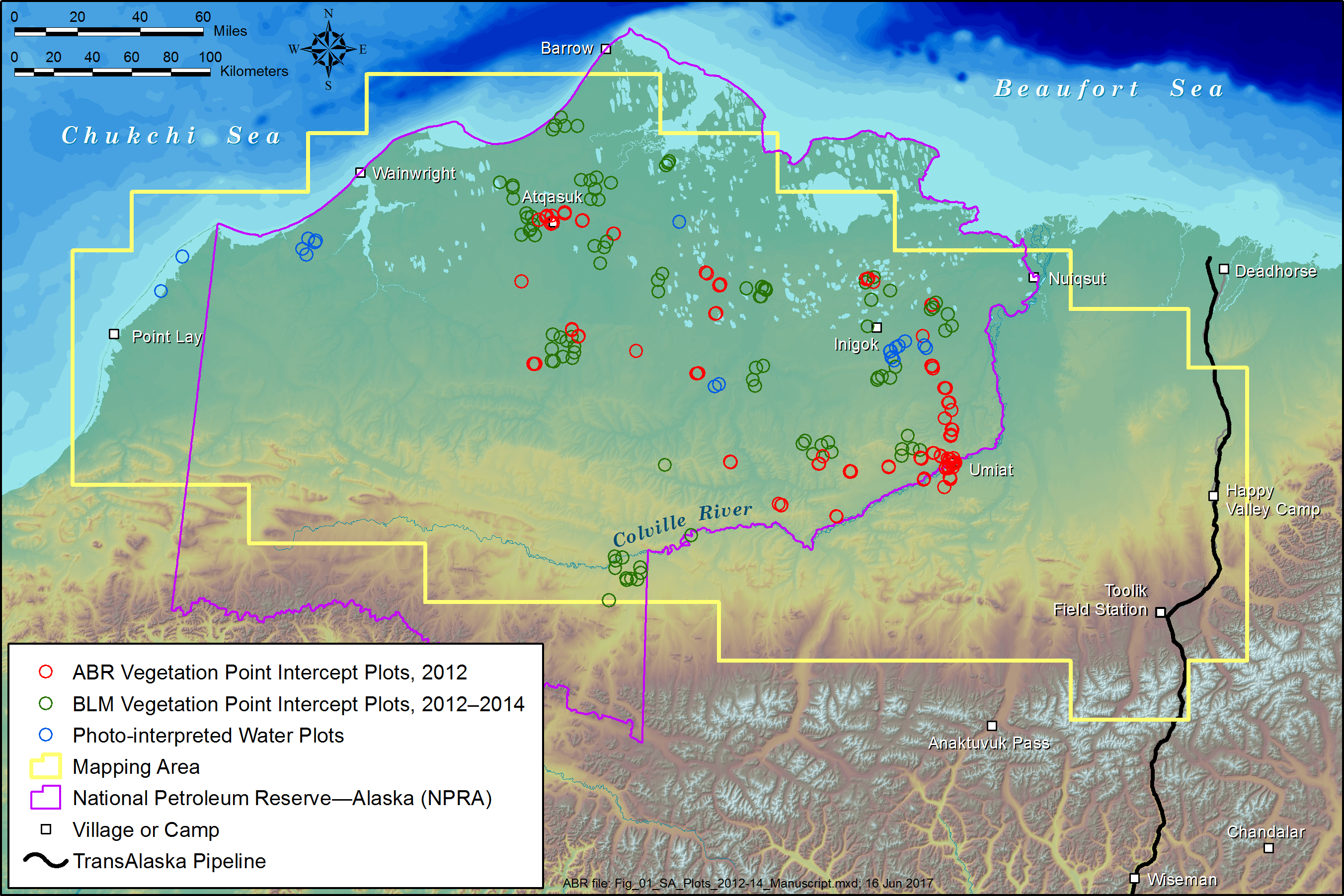
Figure1. Map of quantitative-cover mapping area showing the distribution of...
-
The dataset's project home pageHTML
ABoVE project site
-
Landing PageLanding Page
Dates
| Metadata Created Date | December 1, 2022 |
|---|---|
| Metadata Updated Date | December 7, 2023 |
Metadata Source
- Data.json Data.json Metadata
Harvested from NASA Data.json
Graphic Preview

Additional Metadata
| Resource Type | Dataset |
|---|---|
| Metadata Created Date | December 1, 2022 |
| Metadata Updated Date | December 7, 2023 |
| Publisher | ORNL_DAAC |
| Maintainer | |
| Identifier | C2143401689-ORNL_CLOUD |
| Data First Published | 2021-08-27 |
| Language | en-US |
| Data Last Modified | 2023-06-12 |
| Category | ABoVE, geospatial |
| Public Access Level | public |
| Bureau Code | 026:00 |
| Metadata Context | https://project-open-data.cio.gov/v1.1/schema/catalog.jsonld |
| Metadata Catalog ID | https://data.nasa.gov/data.json |
| Schema Version | https://project-open-data.cio.gov/v1.1/schema |
| Catalog Describedby | https://project-open-data.cio.gov/v1.1/schema/catalog.json |
| Citation | Macander, M.J., G.V. Frost, P.R. Nelson, and C.S. Swingley. 2020. ABoVE: Tundra Plant Functional Type Continuous-Cover, North Slope, Alaska, 2010-2015. ORNL DAAC, Oak Ridge, Tennessee, USA. https://doi.org/10.3334/ORNLDAAC/1830 |
| Graphic Preview Description | Figure1. Map of quantitative-cover mapping area showing the distribution of field plots, North Slope, Alaska. ABR, ABR, Inc.-Environmental Research & Services. BLM, Bureau of Land Management (figure is from Macander et al., 2017). |
| Graphic Preview File | https://daac.ornl.gov/ABOVE/guides/AK_Tundra_PFT_FractionalCover_Fig1.png |
| Harvest Object Id | 4acfeb56-c355-469d-aceb-8ecf5928e3da |
| Harvest Source Id | 58f92550-7a01-4f00-b1b2-8dc953bd598f |
| Harvest Source Title | NASA Data.json |
| Homepage URL | https://doi.org/10.3334/ORNLDAAC/1830 |
| Metadata Type | geospatial |
| Old Spatial | -167.48 65.59 -143.98 73.8 |
| Program Code | 026:001 |
| Source Datajson Identifier | True |
| Source Hash | a8c96b18f716891bf147d67337374b1f2b12b94913705be1e3a9b675b8dcb4cd |
| Source Schema Version | 1.1 |
| Spatial | |
| Temporal | 2010-07-01T00:00:00Z/2015-08-31T23:59:59Z |
Didn't find what you're looking for? Suggest a dataset here.

