
-
Federal
CERES and GEO-Enhanced TOA, Within-Atmosphere and Surface Fluxes, Clouds and Aerosols Monthly-Averaged 1-Hourly Terra-NOAA20 Edition4A NGDA recent views
National Aeronautics and Space Administration —
CER_SYN1deg-MHour_Terra-NOAA20_Edition4A is the Clouds and the Earth's Radiant Energy System (CERES) and geostationary (GEO)-Enhanced Top-of-Atmosphere (TOA), Within-... -
Federal
NACP: MODIS Daily Land Incident 4-km PAR Images For North America, 2003-2005 NGDA recent views
National Aeronautics and Space Administration —
This data set contains daily Moderate Resolution Imaging Spectroradiometer (MODIS) land incident photosynthetically active radiation (PAR) images over North America... -
Federal
CERES and GEO-Enhanced TOA, Within-Atmosphere and Surface Fluxes, Clouds and Aerosols Monthly Terra-NPP Edition1A NGDA recent views
National Aeronautics and Space Administration —
CER_SYN1deg-Month_Terra-NPP_Edition1A is the Clouds and the Earth's Radiant Energy System (CERES) and geostationary (GEO)-Enhanced Top-of-Atmosphere (TOA) Within-... -
Federal
CERES and GEO-Enhanced TOA, Within-Atmosphere and Surface Fluxes, Clouds and Aerosols Daily Terra-NOAA20 Edition4A NGDA recent views
National Aeronautics and Space Administration —
CER_SYN1deg-Day_Terra-NOAA20_Edition4A is the Clouds and the Earth's Radiant Energy System (CERES) and geostationary (GEO)-Enhanced Top-of-Atmosphere (TOA), Within-... -
Federal
CERES and GEO-Enhanced TOA, Within-Atmosphere and Surface Fluxes, Clouds and Aerosols Daily Terra-NPP Edition1A NGDA recent views
National Aeronautics and Space Administration —
CER_SYN1deg-Day_Terra-NPP_Edition1A is the Clouds and the Earth's Radiant Energy System (CERES) and geostationary (GEO)-Enhanced Top-of-Atmosphere (TOA) and Surface... -
Federal
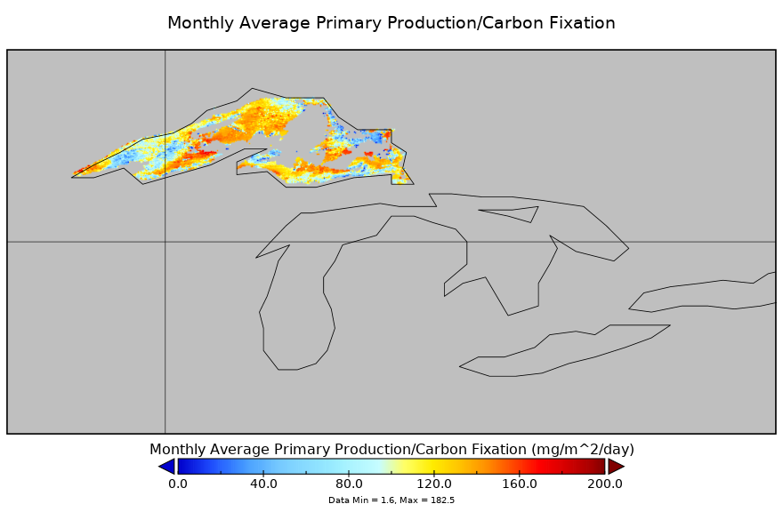
Carbon Monitoring System Lake Superior Primary Production Monthly V1 (CMSLakeSuperiorPPM) at GES DISC NGDA recent views
National Aeronautics and Space Administration —
Monthly Average primary production/carbon fixation data for Lake Superior. The primary production data is derived using MODIS imagery with model data. The NASA Carbon... -
Federal
Combined ASTER and MODIS Emissivity database over Land (CAMEL) Uncertainty Monthly Global 0.05Deg V001 NGDA recent views
National Aeronautics and Space Administration —
The NASA Making Earth System Data Records for Use in Research Environments (MEaSUREs) (https://earthdata.nasa.gov/community/community-data-system-programs/measures-... -
Federal
CERES and GEO-Enhanced TOA, Within-Atmosphere and Surface Fluxes, Clouds and Aerosols Daily Terra-Aqua Edition4A NGDA recent views
National Aeronautics and Space Administration —
CER_SYN1deg-Day_Terra-Aqua-MODIS_Edition4A is the Clouds and the Earth's Radiant Energy System (CERES) and geostationary (GEO)-Enhanced Top-of-Atmosphere (TOA),... -
Federal
Combined ASTER and MODIS Emissivity database over Land (CAMEL) Emissivity Monthly Global 0.05Deg V001 NGDA recent views
National Aeronautics and Space Administration —
The NASA Making Earth System Data Records for Use in Research Environments (MEaSUREs) (https://earthdata.nasa.gov/community/community-data-system-programs/measures-... -
Federal
ABoVE: Ignitions, Burned Area, and Emissions of Fires in AK, YT, and NWT, 2001-2018 NGDA recent views
National Aeronautics and Space Administration —
This dataset provides estimates of daily burned area, carbon emissions, and uncertainty, and daily fire ignition locations for boreal fires in Alaska, U.S., and in... -
Federal
CARVE: Alaskan Fire Emissions Database (AKFED), 2001-2013 NGDA recent views
National Aeronautics and Space Administration —
This data set provides estimates of annual carbon emissions (kg carbon per square meter) from boreal fires at 450-m resolution for the state of Alaska between 2001... -
Federal
Greenness Trends and Carbon Stocks of Mangrove Forests Across Mexico, 2001-2015 NGDA recent views
National Aeronautics and Space Administration —
This dataset provides estimates of greenness trends, above- and belowground carbon stocks, and climate variables of the persistent mangrove forests on the coasts of... -
Federal
ABoVE: TVPRM Simulated Net Ecosystem Exchange, Alaskan North Slope, 2008-2017 NGDA recent views
National Aeronautics and Space Administration —
This dataset includes hourly net ecosystem exchange (NEE) simulated by the Tundra Vegetation Photosynthesis and Respiration Model (TVPRM) at 30 km horizontal... -
Federal
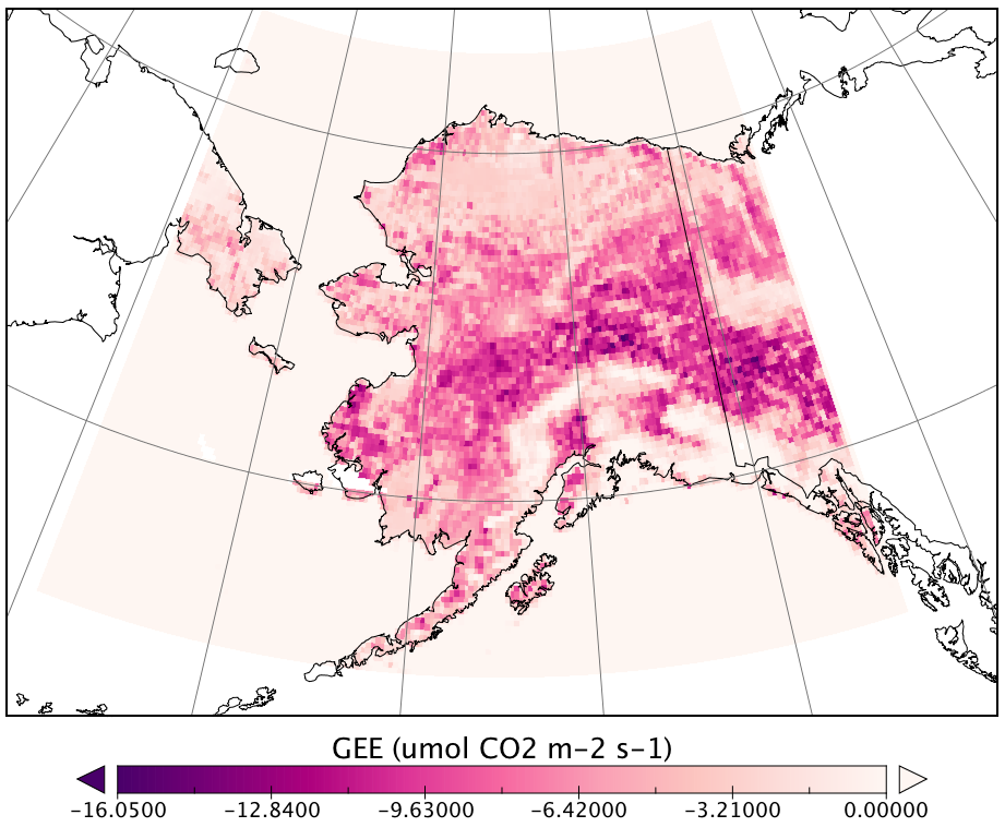
CARVE Modeled Gross Ecosystem CO2 Exchange and Respiration, Alaska, 2012-2014 NGDA recent views
National Aeronautics and Space Administration —
This data set provides 3-hourly estimates of gross ecosystem CO2 exchange (GEE) and respiration (autotrophic and heterotrophic) for the state of Alaska from 2012 to... -
Federal
MODIS/Terra Thermal Anomalies/Fire 5-Min L2 Swath 1km NRT NGDA recent views
National Aeronautics and Space Administration —
The MODIS/Terra Thermal Anomalies/Fire 5-Min L2 Swath 1km Near Real Time (NRT), short name MOD14, product is primarily derived from MODIS 4- and 11-micrometer... -
Federal
Aqua MODIS Global Mapped Inherent Optical Properties (IOP) - Near Real-time (NRT) Data, version R2022.0 NGDA recent views
National Aeronautics and Space Administration —
The Ocean Biology DAAC produces near real-time (quicklook) products using the best-available combination of ancillary data from meteorological and ozone data. As... -
Federal
Aqua MODIS Global Binned Inherent Optical Properties (IOP) - Near Real-time (NRT) Data, version R2022.0 NGDA recent views
National Aeronautics and Space Administration —
The Ocean Biology DAAC produces near real-time (quicklook) products using the best-available combination of ancillary data from meteorological and ozone data. As... -
Federal
ISLSCP II Continuous Fields of Vegetation Cover, 1992-1993 NGDA recent views
National Aeronautics and Space Administration —
The objective of this study was to derive continuous fields of vegetation cover from multi-temporal Advanced Very High Resolution Radiometer (AVHRR) data using all... -
Federal
ISLSCP II FASIR-adjusted NDVI, 1982-1998 NGDA recent views
National Aeronautics and Space Administration —
The Fourier-Adjusted, Sensor and Solar zenith angle corrected, Interpolated, Reconstructed (FASIR) adjusted Normalized Difference Vegetation Index (NDVI) data sets... -
Federal
ISLSCP II IGBP DISCover and SiB Land Cover, 1992-1993 NGDA recent views
National Aeronautics and Space Administration —
This data set describes the geographic distributions of 17 classes of land cover based on the International Geosphere-Biosphere DISCover land cover legend (Loveland...

Official websites use .gov
A
.gov website belongs to an official government
organization in the United States.
Secure .gov websites use HTTPS
A
lock (
) or https:// means you’ve safely connected to
the .gov website. Share sensitive information only on official,
secure websites.