NACP: MODIS Daily Land Incident 4-km PAR Images For North America, 2003-2005
Access & Use Information
Downloads & Resources
-
Google Scholar search resultsHTML
Search results for publications that cite this dataset by its DOI.
-
Download this datasetHTML
This link allows direct data access via Earthdata login
-
View documentation related to this datasetHTML
ORNL DAAC Data Set Documentation
-
This dataset's landing pageHTML
Data set Landing Page DOI URL
-
View documentation related to this datasetPDF
Data Set Documentation
-
View documentation related to this datasetZIP
Data Set Documentation
-
Get a related visualizationJPEG
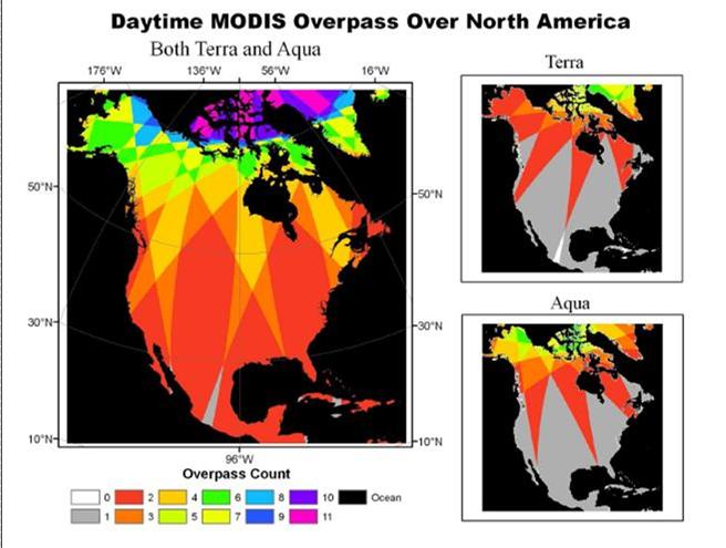
MODIS overpass of North America based on the Terra and Aqua orbital...
-
Landing PageLanding Page
Dates
| Metadata Created Date | May 30, 2023 |
|---|---|
| Metadata Updated Date | December 7, 2023 |
Metadata Source
- Data.json Data.json Metadata
Harvested from NASA Data.json
Graphic Preview

Additional Metadata
| Resource Type | Dataset |
|---|---|
| Metadata Created Date | May 30, 2023 |
| Metadata Updated Date | December 7, 2023 |
| Publisher | ORNL_DAAC |
| Maintainer | |
| Identifier | C2631225371-ORNL_CLOUD |
| Data First Published | 2012-12-21 |
| Language | en-US |
| Data Last Modified | 2023-06-12 |
| Category | NACP, geospatial |
| Public Access Level | public |
| Bureau Code | 026:00 |
| Metadata Context | https://project-open-data.cio.gov/v1.1/schema/catalog.jsonld |
| Metadata Catalog ID | https://data.nasa.gov/data.json |
| Schema Version | https://project-open-data.cio.gov/v1.1/schema |
| Catalog Describedby | https://project-open-data.cio.gov/v1.1/schema/catalog.json |
| Citation | Liang, S., and D. Wang. 2012. NACP: MODIS Daily Land Incident 4-km PAR Images For North America, 2003-2005. ORNL DAAC, Oak Ridge, Tennessee, USA. http://dx.doi.org/10.3334/ORNLDAAC/1140 |
| Graphic Preview Description | MODIS overpass of North America based on the Terra and Aqua orbital simulation from GMT 12:00 to 24:00, June 16, 2006. From Wang et al. (2010). |
| Graphic Preview File | https://daac.ornl.gov/NACP/guides/liang_figure1.jpg |
| Harvest Object Id | 7f2c8f0f-674d-4e6a-b9d2-9d54eb883ed0 |
| Harvest Source Id | 58f92550-7a01-4f00-b1b2-8dc953bd598f |
| Harvest Source Title | NASA Data.json |
| Homepage URL | https://doi.org/10.3334/ORNLDAAC/1140 |
| Metadata Type | geospatial |
| Old Spatial | -180.0 0.0 0.0 90.0 |
| Program Code | 026:001 |
| Source Datajson Identifier | True |
| Source Hash | b90f61f170016e8d4f8475c531a34e73e28779fa4d4ed521a6ac7288679c518f |
| Source Schema Version | 1.1 |
| Spatial | |
| Temporal | 2003-01-01T00:00:00Z/2005-12-31T23:59:59Z |
Didn't find what you're looking for? Suggest a dataset here.

