
-
Federal
THIR/Nimbus-7 Level 1 Cloud Data for SBUV/TOMS V001 (THIRN7L1BCLT) at GES DISC
National Aeronautics and Space Administration —
THIRN7L1BCLT is the Nimbus-7 Temperature-Humidity Infrared Radiometer (THIR) Level 1 Cloud Data for SBUV/TOMS (BCLT) product and contains total cloud amounts;... -
Federal
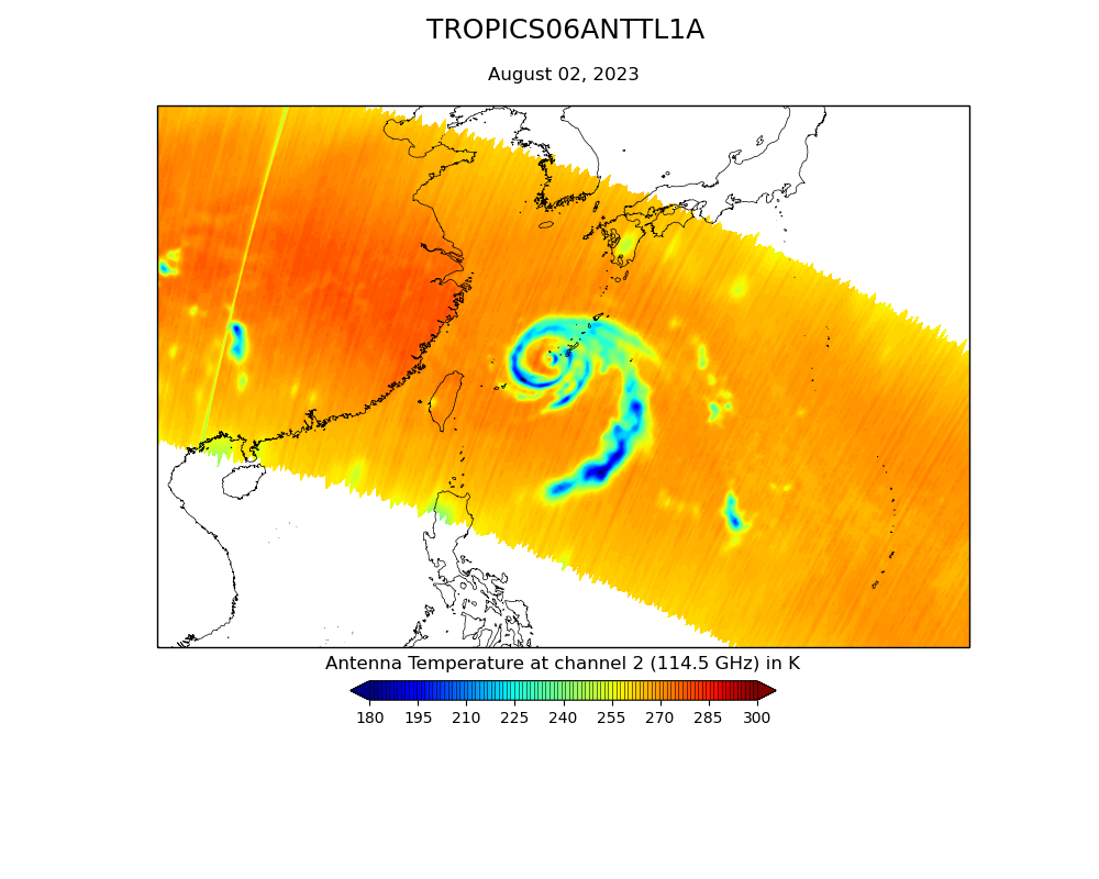
TROPICS07 L2B Deep Multispectral INtensity (DMIN) of Tropical Cyclones Estimator Algorithm V0.2
National Aeronautics and Space Administration —
The "Time-Resolved Observations of Precipitation structure and storm Intensity with a Constellation of Smallsats" (TROPICS) mission has a goal of providing nearly... -
Federal
ATTREX-Aircraft_navigational_and_meteorological_Measurements
National Aeronautics and Space Administration —
ATTREX-Aircraft_navigational_meteorological_Measurements are in-situ navigational and meteorological measurements collected onboard the Global Hawk Unihabited Aerial... -
Federal
TROPICS03 L2A Unified Resolution Brightness Temperatures V1.0
National Aeronautics and Space Administration —
The "Time-Resolved Observations of Precipitation structure and storm Intensity with a Constellation of Smallsats" (TROPICS) mission has a goal of providing nearly... -
Federal
TROPICS07 L1A Orbital Geolocated Native-Resolution Antenna Temperatures V0.2
National Aeronautics and Space Administration —
The "Time-Resolved Observations of Precipitation structure and storm Intensity with a Constellation of Smallsats" (TROPICS) mission has a goal of providing nearly... -
Federal
Supporting Information for Doppler Orbitography and Radiopositioning Integrated by Satellite (DORIS) Data and Products from NASA CDDIS
National Aeronautics and Space Administration —
Doppler Orbitography and Radiopositioning Integrated by Satellite (DORIS) Data (multi-day files) from the NASA Crustal Dynamics Data Information System (CDDIS). DORIS... -
Federal
AIRS/Aqua Granule map product V005 (AIRXAMAP) at GES DISC
National Aeronautics and Space Administration —
The Atmospheric Infrared Sounder (AIRS) is a grating spectrometer (R = 1200) aboard the second Earth Observing System (EOS) polar-orbiting platform, EOS Aqua. In... -
Federal
TOVS GLA 5 DAY GRIDS from NOAA-12 V01 (TOVSA5ND) at GES DISC
National Aeronautics and Space Administration —
This dataset (TOVSA5ND) contains the TIROS Operational Vertical Sounder (TOVS) level 3 geophysical parameters derived using data from NOAA-12 and the physical... -
Federal
TOVS GLA DAILY GRIDS from TIROSN V01 (TOVSADTN) at GES DISC
National Aeronautics and Space Administration —
This dataset (TOVSADTN) contains the TIROS Operational Vertical Sounder (TOVS) level 3 geophysical parameters derived using data from TIROS-N and the physical... -
Federal
Annual Global High-Resolution Extreme Heat Estimates (GEHE), 1983-2016
National Aeronautics and Space Administration —
The Annual Global High-Resolution Extreme Heat Estimates (GEHE), 1983-2016 data set provides global 0.05 degrees (~5 km) gridded annual counts of the number of days... -
Federal
TROPICS01 Pathfinder L2B Instantaneous Surface Rain Rate (ISRR) V1.0
National Aeronautics and Space Administration —
The "Time-Resolved Observations of Precipitation structure and storm Intensity with a Constellation of Smallsats" (TROPICS) mission has a goal of providing nearly... -
Federal
MERRA-2 inst3_3d_asm_Nv: 3d,3-Hourly,Instantaneous,Model-Level,Assimilation,Assimilated Meteorological Fields 0.625 x 0.5 degree V5.12.4 (M2I3NVASM) at GES DISC
National Aeronautics and Space Administration —
M2I3NVASM (or inst3_3d_asm_Nv) is an instantaneous 3-dimensional 3-hourly data collection in Modern-Era Retrospective analysis for Research and Applications version 2... -
Federal
TOVS GLA DAILY GRIDS from NOAA-9 V01 (TOVSADNF) at GES DISC
National Aeronautics and Space Administration —
This dataset (TOVSADNF) contains the TIROS Operational Vertical Sounder (TOVS) level 3 geophysical parameters derived using data from NOAA-9 and the physical... -
Federal
Nimbus Temperature-Humidity Infrared Radiometer 6.7 µm Water Vapor Remapped Digital Data Daily L3, GeoTIFF V001
National Aeronautics and Space Administration —
This data set (NmTHIR67-3G) consists of daily, global composites of radiative temperatures obtained in the 6.7 µm water vapor window (6.5 µm - 7.0 µm) by the... -
Federal
TROPICS07 L2A Unified Resolution Brightness Temperatures V0.2
National Aeronautics and Space Administration —
The "Time-Resolved Observations of Precipitation structure and storm Intensity with a Constellation of Smallsats" (TROPICS) mission has a goal of providing nearly... -
Federal
TROPICS07 L1B Orbital Geolocated Native-Resolution Brightness Temperatures V0.2
National Aeronautics and Space Administration —
The "Time-Resolved Observations of Precipitation structure and storm Intensity with a Constellation of Smallsats" (TROPICS) mission has a goal of providing nearly... -
Federal
TOVS GLA 5 DAY GRIDS from NOAA-9 V01 (TOVSA5NF) at GES DISC
National Aeronautics and Space Administration —
This dataset (TOVSA5NF) contains the TIROS Operational Vertical Sounder (TOVS) level 3 geophysical parameters derived using data from NOAA-9 and the physical... -
Federal
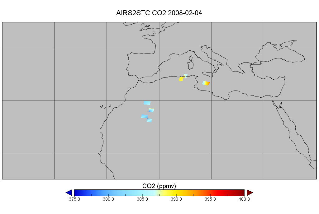
AIRS/Aqua L2 CO2 in the free troposphere (AIRS-only) V005 (AIRS2STC) at GES DISC
National Aeronautics and Space Administration —
The Atmospheric Infrared Sounder (AIRS) is a grating spectrometer (R = 1200) aboard the second Earth Observing System (EOS) polar-orbiting platform, EOS Aqua. In... -
Federal
Sounder SIPS: Suomi NPP ATMS Level 3 RAMSES2 Standard Gridded Monthly V3 at GES DISC
National Aeronautics and Space Administration —
This level 3 monthly product is generated from the RAMSES (Retrieval Algorithm for Microwave Sounders in Earth Science) II algorithm.The RAMSES II algorithm is a... -
Federal
Sounder SIPS: Suomi NPP CrIMSS Level 3 Specific Quality Control Gridded Monthly SiFSAP V2 (SNDRSNIML3SMSFSP) at GES DISC
National Aeronautics and Space Administration —
The SIFSAP (Single Field-of-View Sounder Atmospheric Products) algorithm provides retrieval for each sounder Field of View (FOV), therefore, it has 3-times higher...

Official websites use .gov
A
.gov website belongs to an official government
organization in the United States.
Secure .gov websites use HTTPS
A
lock (
) or https:// means you’ve safely connected to
the .gov website. Share sensitive information only on official,
secure websites.