
-
Federal
Rodent Research-1 (RR1) National Lab Validation Flight: Mouse liver transcriptomic proteomic and epigenomic data
National Aeronautics and Space Administration —
The Rodent Reasearch-1 National Lab (RR-1 CASIS) experiment was performed to study the effect of microgravity on muscle wasting. RNA DNA and protein were purified... -
Federal
USGS High Resolution Orthoimagery
National Aeronautics and Space Administration —
High resolution orthorectified images combine the image characteristics of an aerial photograph with the geometric qualities of a map. An orthoimage is a uniform-... -
Federal
Catalog of Gamma-Ray Bursts
National Aeronautics and Space Administration —
This GRBs Catalog (GRBCAT) records high level information of the GRBs detected since their discovery in 1967. The catalog has been created using publications that... -
Federal
Gridded Population of the World, Version 4 (GPWv4): Population Density, Revision 11
National Aeronautics and Space Administration —
The Gridded Population of the World, Version 4 (GPWv4): Population Density, Revision 11 consists of estimates of human population density (number of persons per... -
Federal
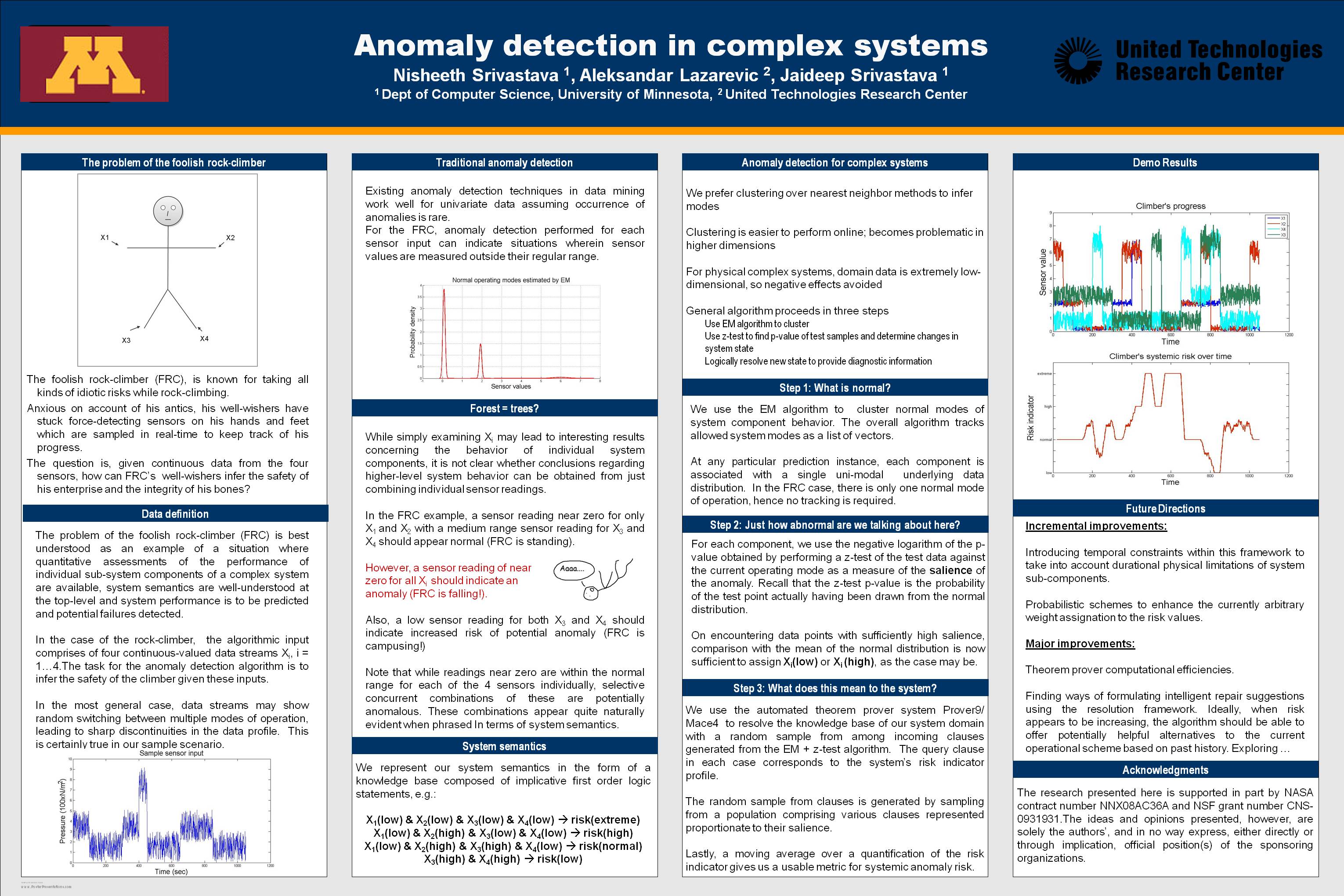
Anomaly Detection for Complex Systems
National Aeronautics and Space Administration —
In performance maintenance in large, complex systems, sensor information from sub-components tends to be readily available, and can be used to make predictions about... -
Federal
EPOXI EXOPLANET TRANSIT OBS - HRIV RAW IMAGES V1.0
National Aeronautics and Space Administration —
This data set set contains raw images of eight known transiting extrasolar planetary systems (hot Jupiters) acquired by the Deep Impact High Resolution Visible CCD... -
Federal
SWOT Sword of Science River Discharge Products Version 1
National Aeronautics and Space Administration —
The SWOT Sword of Science River Discharge Products dataset from the Surface Water and Ocean Topography (SWOT) mission and produced by the Discharge Algorithm Working... -
Federal
Gazetteer of Planetary Nomenclature: Moon: 1:1 million-scale maps of the Moon
National Aeronautics and Space Administration —
The purpose of the lunar maps is to provide an up-to-date and comprehensive depiction on lunar nomenclature approved by the International Astronomical Union (IAU). -
Federal
DEEP IMPACT SPICE KERNELS V1.0
National Aeronautics and Space Administration —
This data set includes the complete set of Deep Impact SPICE data files (``kernel files''), which can be accessed using SPICE software. The SPICE data contains... -
Federal
ASTEROID DYNAMICAL FAMILIES V4.1
National Aeronautics and Space Administration —
Dynamical family classification of asteroids by Zappala, et al., based on the hierarchical clustering method. -
Federal
Low Elevation Coastal Zone (LECZ) Urban-Rural Population and Land Area Estimates, Version 3
National Aeronautics and Space Administration —
The Low Elevation Coastal Zone (LECZ) Urban-Rural Population and Land Area Estimates, Version 3 data set contains land areas with urban, quasi-urban, rural, and total... -
Federal
MODIS/Aqua Near Real Time (NRT) 5-min Spacecraft attitude data from GBAD to be read via SDP Toolkit Binary Format
National Aeronautics and Space Administration —
PM1ATTNR is the Aqua Near Real Time (NRT) daily spacecraft attitude data file in native format. This is MODIS Ancillary Data. The data collection consists of PM1... -
Federal
SMAP L4 Global 3-hourly 9 km EASE-Grid Surface and Root Zone Soil Moisture Geophysical Data V007
National Aeronautics and Space Administration —
SMAP Level-4 (L4) surface and root zone soil moisture data are provided in three products: * SMAP L4 Global 3-hourly 9 km EASE-Grid Surface and Root Zone Soil... -
Federal
Suomi-NPP VIIRS Global Mapped Normalized Difference Vegetation Index Land Reflectance Data, version R2022.0
National Aeronautics and Space Administration —
The Visible and Infrared Imager/Radiometer Suite (VIIRS) is a multi-disciplinary instrument that is being flown on the Joint Polar Satellite System (JPSS) series of... -
Federal
Real System Failures
National Aeronautics and Space Administration —
This resource area contains descriptions of actual electronic systems failure scenarios with an emphasis on the diversity of failure modes and effects that can befall... -
Federal
Supporting Information for Global Navigation Satellite System (GNSS) Data and Products from NASA CDDIS
National Aeronautics and Space Administration —
This dataset consists of supporting information for use of ground-based Global Navigation Satellite System (GNSS) data and products from the NASA Crustal Dynamics... -
Federal
SRTM Water Body Data
National Aeronautics and Space Administration —
The SRTM Water Body Data files are a by-product of the data editing performed by the National Geospatial-Intelligence Agency (NGA) to produce the finished SRTM... -
Federal
Combined GPS Broadcast Ephemeris Data (30-second sampling, hourly files) from NASA CDDIS
National Aeronautics and Space Administration —
This dataset consists of ground-based Global Navigation Satellite System (GNSS) Combined Broadcast Ephemeris Data (hourly files of all distinct navigation messages... -
Federal
SDG Indicator 9.1.1: Rural Access Index (RAI), 2023 Release
National Aeronautics and Space Administration —
The SDG Indicator 9.1.1: The Rural Access Index (RAI), 2023 Release data set, part of the SDGI collection, measures the proportion of the rural population who live...

Official websites use .gov
A
.gov website belongs to an official government
organization in the United States.
Secure .gov websites use HTTPS
A
lock (
) or https:// means you’ve safely connected to
the .gov website. Share sensitive information only on official,
secure websites.