
-
Federal
USGS Group on Earth Observations (GEO) Global Agricultural Monitoring (GLAM) Ukraine
National Aeronautics and Space Administration —
The objective of GEO is to fulfill a vision of a world where decisions and actions are informed by coordinated, comprehensive and sustained Earth Observation (EO).... -
Federal
SWOT Level 2 KaRIn Low Rate Sea Surface Height Data Product, Version 2.0
National Aeronautics and Space Administration —
The SWOT Level 2 KaRIn Low Rate Sea Surface Height Data Product from the Surface Water Ocean Topography (SWOT) mission provides global sea surface height and... -
Federal
PSP FIELDS Fluxgate Magnetometer (MAG) Magnetic Field Vectors, Radial-Tangential-Normal, RTN, Coordinates, Full Resolution, Level 2 (L2), 3.413 ms Data
National Aeronautics and Space Administration —
Parker Solar Probe FIELDS Instrument Suite Fluxgate Magnetometer, MAG, Data: The time resolution of the MAG time series data varies with instrument mode ranging from... -
Federal
FLASHFlux NOAA-20 Daily Gridded TOA and Surfaces/Clouds data Version 1A
National Aeronautics and Space Administration —
FLASH_TISA_NOAA20_Version1A is the Fast Longwave And SHortwave Fluxes (FLASHFlux) Daily Gridded Single Satellite Top-of-Atmosphere (TOA) and Surfaces/Clouds Version... -
Federal
PSP FIELDS Fluxgate Magnetometer (MAG) Magnetic Field Vectors, Radial-Tangential-Normal, RTN, Coordinates, 4 samples/cycle, Level 2 (L2), 3.413 ms Data
National Aeronautics and Space Administration —
Parker Solar Probe FIELDS Instrument Suite Fluxgate Magnetometer, MAG, Data: The time resolution of the MAG time series data varies with instrument mode ranging from... -
Federal
CALIPSO Lidar Level 2 Blowing Snow - Antarctica, V1-01
National Aeronautics and Space Administration —
CAL_LID_L2_BlowingSnow_Antarctica-Standard-V1-01 is the Cloud-Aerosol Lidar and Infrared Pathfinder Satellite Observations (CALIPSO) Lidar Level 2 Blowing Snow -... -
Federal
MLS/Aura Level 3 Daily Binned Ozone (O3) Mixing Ratio on Zonal and Similar Grids V004 (ML3DZO3) at GES DISC
National Aeronautics and Space Administration —
ML3DZO3 is the EOS Aura Microwave Limb Sounder (MLS) daily binned on zonal and assorted vertical grids product for ozone (O3) derived from radiances measured by the... -
Federal
USGS Group on Earth Observations (GEO) Global Agricultural Monitoring (GLAM) Ethiopia
National Aeronautics and Space Administration —
The objective of GEO is to fulfil a vision of a world where decisions and actions are informed by coordinated, comprehensive and sustained Earth Observation (EO).... -
Federal
GPM Ground Validation R. M. Young Marine Anemometer UConn
National Aeronautics and Space Administration —
The GPM Ground Validation R.M. Young Marine Anemometer UConn dataset includes wind speed and wind direction data collected by the Young Wind Monitor-MA. These data... -
Federal
PREFIRE Auxiliary Satellite Data for PREFIRE Satellite 2 R01
National Aeronautics and Space Administration —
PREFIRE (Polar Radiant Energy in the Far InfraRed Experiment) Auxiliary Satellite Data for PREFIRE Satellite 2 contains data fields extracted from external satellite... -
Federal
Park Site (PKS) Ground-based Vector Magnetic Field (L2) 1.0 s Data
National Aeronautics and Space Administration —
Park Site, SK, Ground-based Vector Magnetic Field Level 2 Data, 1.0 s Time Resolution, Station Code: (PKS), Station Location: (GEO Latitude 52.5, Longitude 252.8),... -
Federal
Swift-BAT 157-Month All-Sky Hard X-Ray Survey
National Aeronautics and Space Administration —
This catalog includes the hard X-ray sources detected in the first 157 months of observations with the Burst Alert Telescope (BAT) coded-mask imager on board the... -
Federal
SMASS ASTEROID SURVEY V2.1
National Aeronautics and Space Administration —
Small Main-Belt Asteroid Spectrographic Survey over the visual range. -
Federal
MLS/Aura Level 3 Daily Binned Chlorine Monoxide (ClO) Mixing Ratio on Assorted Grids V004 (ML3DBCLO) at GES DISC
National Aeronautics and Space Administration —
ML3DBCLO is the EOS Aura Microwave Limb Sounder (MLS) daily binned on various vertical grids product for chlorine monoxide (ClO) derived from radiances measured... -
Federal
INTEX-B Ground data
National Aeronautics and Space Administration —
INTEX-NA is a two phase experiment that aims to understand the transport and transformation of gases and aerosols on transcontinental/intercontinental scales and... -
Federal
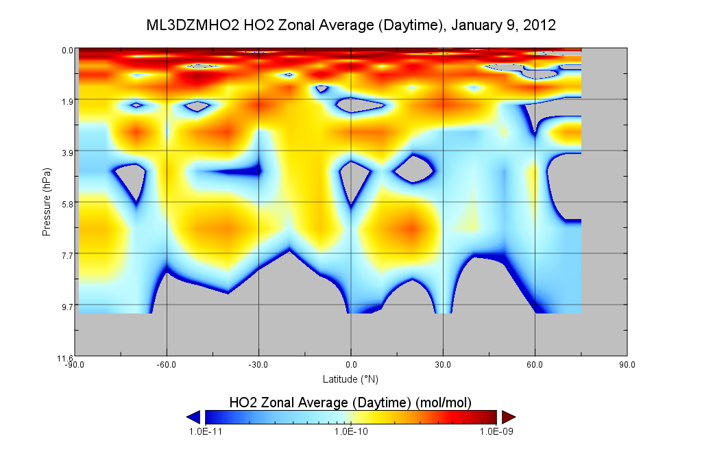
MLS/Aura Level 3 Hydroperoxy (HO2) Daily 10degrees Lat Zonal Mean V004 (ML3DZMHO2) at GES DISC
National Aeronautics and Space Administration —
ML3DZMHO2 is the EOS Aura Microwave Limb Sounder (MLS) daily zonal mean product for hydroperoxy derived from radiances measured in two bands from the 640 GHz... -
Federal
MASTER: Geological Earth Mapping Experiment (GEMx), Spring 2024
National Aeronautics and Space Administration —
This dataset includes Level 1B (L1B) data products from the MODIS/ASTER Airborne Simulator (MASTER) instrument. The spectral data were collected during 26 flights... -
Federal
MLS/Aura Level 3 Daily Binned Hydroxyl (OH) Mixing Ratio on Zonal and Similar Grids V005 (ML3DZOH) at GES DISC
National Aeronautics and Space Administration —
ML3DZOH is the EOS Aura Microwave Limb Sounder (MLS) daily binned on zonal and assorted vertical grids product for hydroxyl (OH) derived from radiances measured by... -
Federal
Microwave Atmospheric Sounder on Cubesat (MASC) CPEX V1
National Aeronautics and Space Administration —
The Microwave Atmospheric Sounder on Cubesat (MASC) CPEX dataset contains products obtained from the MASC instrument onboard the DC-8 aircraft. These data were...

Official websites use .gov
A
.gov website belongs to an official government
organization in the United States.
Secure .gov websites use HTTPS
A
lock (
) or https:// means you’ve safely connected to
the .gov website. Share sensitive information only on official,
secure websites.