
-
Federal
VEMAP 2: Annual Ecosystem Model Responses to U.S. Climate Change, 1994-2100
National Aeronautics and Space Administration —
Phase 2 of the VEMAP Project developed historical (1895-1993) gridded data sets of climate (temperature, precipitation, solar radiation, humidity, and wind speed) and... -
Federal
Daymet: Daily Surface Weather Data on a 1-km Grid for North America, Version 4 R1
National Aeronautics and Space Administration —
This dataset provides Daymet Version 4 R1 data as gridded estimates of daily weather parameters for North America, Hawaii, and Puerto Rico. Daymet variables include... -
Federal
Global Forest Ecosystem Structure and Function Data For Carbon Balance Research
National Aeronautics and Space Administration —
A comprehensive global database has been assembled to quantify CO2 fluxes and pathways across different levels of integration (from photosynthesis up to net ecosystem... -
Federal
CARVE: L1 In-situ Carbon and CH4 Flux and Meteorology at EC Towers, Alaska, 2011-2015
National Aeronautics and Space Administration —
This data set provides ground in situ flux and meteorological science data from fixed instruments at three eddy covariance tower sites located in the Alaskan Arctic... -
Federal
CARVE: L2 Atmospheric CO2, CO and CH4 Concentrations, Harvard CRDS, Alaska, 2012-2014
National Aeronautics and Space Administration —
This data set provides atmospheric carbon dioxide (CO2), methane (CH4), and carbon monoxide (CO) concentrations from airborne campaigns over the Alaskan and Canadian... -
Federal
NWS Daily Climatology Data: 1985 (SNF)
National Aeronautics and Space Administration —
Daily min, max, average temperature (F), precipitation (water equivalent in inches), and daily insolation (Langleys) for the Superior National Forest area as... -
Federal
NACP Site: Tower Meteorology, Flux Observations with Uncertainty, and Ancillary Data
National Aeronautics and Space Administration —
This data set contains meteorological, carbon cycle flux, phenology, and ancillary data measured at 47 eddy covariance flux tower sites across North America. The data... -
Federal
BOREAS/SRC AMS Suite A Surface Meteorological and Radiation Data: 1996
National Aeronautics and Space Administration —
Contains the data collected in 1996 by the AMS suite A instrument set operated by SRC and provided to BORIS. -
Federal
ABoVE: Monthly Hydrological Fluxes for Canada and Alaska, 1979-2018
National Aeronautics and Space Administration —
This dataset provides modeled estimates of monthly hydrological fluxes at 0.25-degree resolution over Alaska and Canada for the years 1979-2018. The estimates were... -
Federal
In-situ Air Temperature and Relative Humidity in Greenbelt, MD, 2013-2015
National Aeronautics and Space Administration —
This data set describes the temperature and relative humidity at 12 locations around Goddard Space Flight Center in Greenbelt MD at 15 minute intervals between... -
Federal
LBA-ECO CD-01 Meteorological Data, Tapajos and Amazon Rivers, Santarem, Brazil: 2001
National Aeronautics and Space Administration —
This data set contains meteorological data collected around the confluence of the Tapajos River with the Amazon River in the Amazon Basin near Santarem, Brazil, in... -
Federal
Bowen Ratio Surface Flux: UNL (FIFE)
National Aeronautics and Space Administration —
Latent & sensible heat flux by Bowen Ratio & aerodynamic characterization of vegetation -
Federal
Daymet: Annual Climate Summaries on a 1-km Grid for North America, Version 4 R1
National Aeronautics and Space Administration —
This dataset provides annual climate summaries derived from Daymet Version 4 R1 daily data at a 1 km x 1 km spatial resolution for five Daymet variables: minimum and... -
Federal
CARVE: L2 Atmospheric CO2, CO, and CH4 Concentrations, CARVE Tower, Alaska, 2011-2015
National Aeronautics and Space Administration —
This data set provides atmospheric methane (CH4), carbon dioxide (CO2), and carbon monoxide (CO) dry air mole fractions and water vapor mole fractions (H2O) from... -
Federal
Burned and Unburned Field Site Data, Noatak, Seward, and North Slope, AK, 2016-2018
National Aeronautics and Space Administration —
This dataset includes field measurements from unburned and burned 10 m x 10 m and 1 m x 1 m plots in the Noatak, Seward, and North Slope regions of the Alaskan tundra... -
Federal
BOREAS RSS-14 GOES-7 Level-1a Visible, Infrared, and Water Vapor Images
National Aeronautics and Space Administration —
The level-1a BOREAS GOES-7 image data was collected by Remote Sensing Science Team-14 (RSS-14) personnel at Florida State University and processed to level-1a... -
Federal
VEMAP 2: Monthly Historical and Future Climate Data, Alaska, USA
National Aeronautics and Space Administration —
This data set provides the results of the development of The Vegetation/Ecosystem Modeling and Analysis Project (VEMAP) Phase 2 transient climate change scenarios for... -
Federal
VEMAP 2: U.S. Monthly Climate, 1895-1993, Version 2
National Aeronautics and Space Administration —
An integrated input data set for ecosystem and vegetation modeling for the conterminous United States. The data set is a ~100 year gridded monthly time series of... -
Federal
Global 30-Year Mean Monthly Climatology, 1901-1960 (New et al.)
National Aeronautics and Space Administration —
A data set of 30-year mean monthly surface climate over global land areas, excluding Antarctica. Interpolated from station data to 0.5 degree lat/lon for a range of... -
Federal
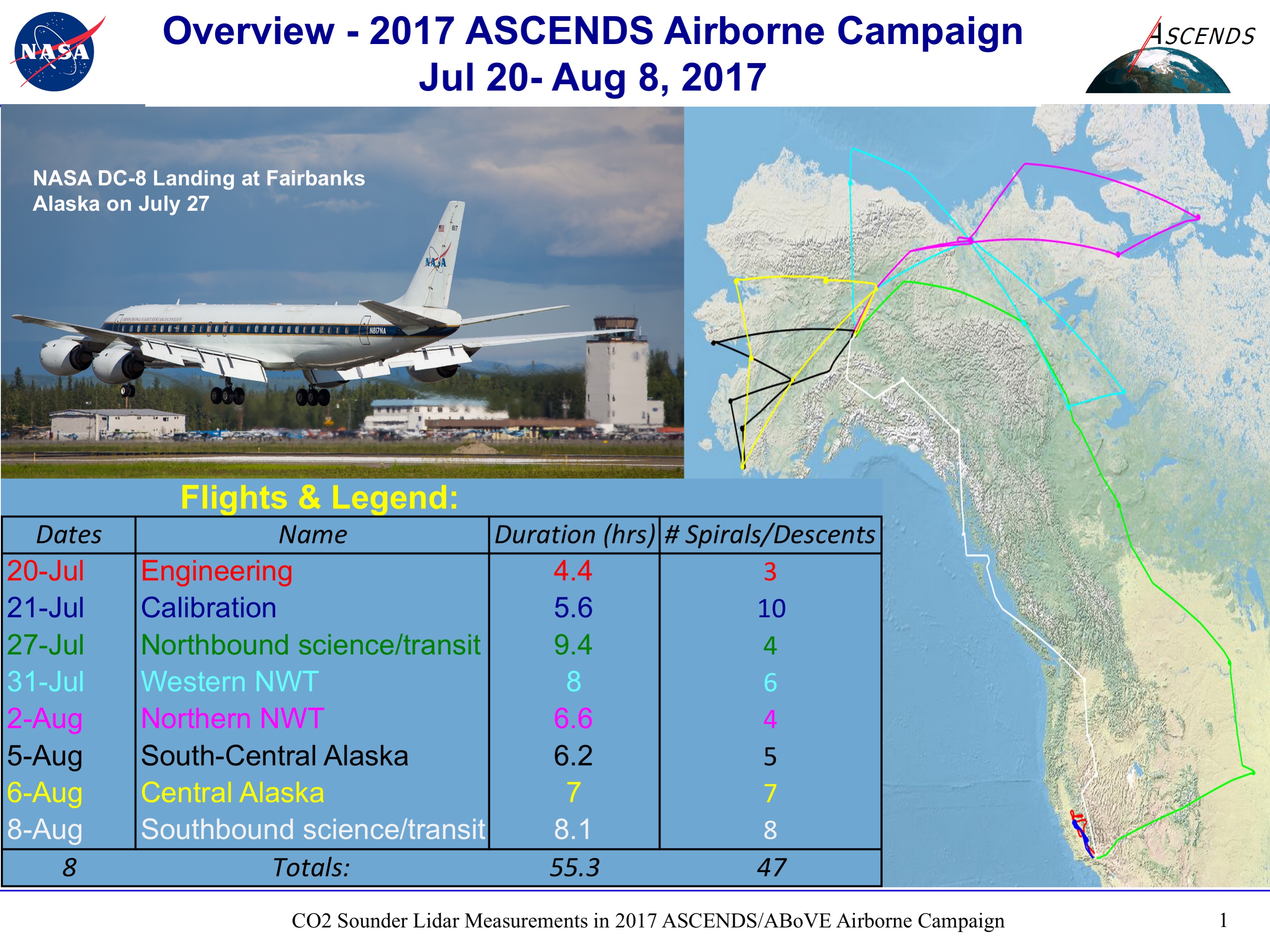
ABoVE/ASCENDS: Merged Atmospheric CO2, CH4, and Meteorological Data, 2017
National Aeronautics and Space Administration —
This dataset provides in situ airborne measurements of atmospheric carbon dioxide (CO2), methane (CH4), water vapor concentrations, air temperature, pressure, and...

Official websites use .gov
A
.gov website belongs to an official government
organization in the United States.
Secure .gov websites use HTTPS
A
lock (
) or https:// means you’ve safely connected to
the .gov website. Share sensitive information only on official,
secure websites.