

NACP Site: Tower Meteorology, Flux Observations with Uncertainty, and Ancillary Data
Access & Use Information
Downloads & Resources
-
Google Scholar search resultsHTML
Search results for publications that cite this dataset by its DOI.
-
Download this datasetHTML
This link allows direct data access via Earthdata login
-
View documentation related to this datasetHTML
ORNL DAAC Data Set Documentation
-
This dataset's landing pageHTML
Data set Landing Page DOI URL
-
View documentation related to this datasetPDF
Data Set Documentation
-
View documentation related to this datasetPDF
Data Set Documentation
-
View documentation related to this datasetPNG
Data Set Documentation
-
View documentation related to this datasetHTML
Data Set Documentation
-
View documentation related to this datasetPDF
Data Set Documentation
-
View documentation related to this datasetCSV
Data Set Documentation
-
View documentation related to this datasetPDF
Data Set Documentation
-
View documentation related to this datasetCSV
Data Set Documentation
-
View documentation related to this datasetPDF
Data Set Documentation
-
View documentation related to this datasetPDF
Data Set Documentation
-
View documentation related to this datasetCSV
Data Set Documentation
-
Get a related visualizationPNG
Browse Image
-
Landing PageLanding Page
Dates
| Metadata Created Date | May 30, 2023 |
|---|---|
| Metadata Updated Date | December 7, 2023 |
Metadata Source
- Data.json Data.json Metadata
Harvested from NASA Data.json
Other Data Resources
- Geoplatform Metadata Information
Graphic Preview
Additional Metadata
| Resource Type | Dataset |
|---|---|
| Metadata Created Date | May 30, 2023 |
| Metadata Updated Date | December 7, 2023 |
| Publisher | ORNL_DAAC |
| Maintainer | |
| Identifier | C2539943609-ORNL_CLOUD |
| Data First Published | 2022-11-29 |
| Language | en-US |
| Data Last Modified | 2023-06-12 |
| Category | NACP, geospatial |
| Public Access Level | public |
| Bureau Code | 026:00 |
| Metadata Context | https://project-open-data.cio.gov/v1.1/schema/catalog.jsonld |
| Metadata Catalog ID | https://data.nasa.gov/data.json |
| Schema Version | https://project-open-data.cio.gov/v1.1/schema |
| Catalog Describedby | https://project-open-data.cio.gov/v1.1/schema/catalog.json |
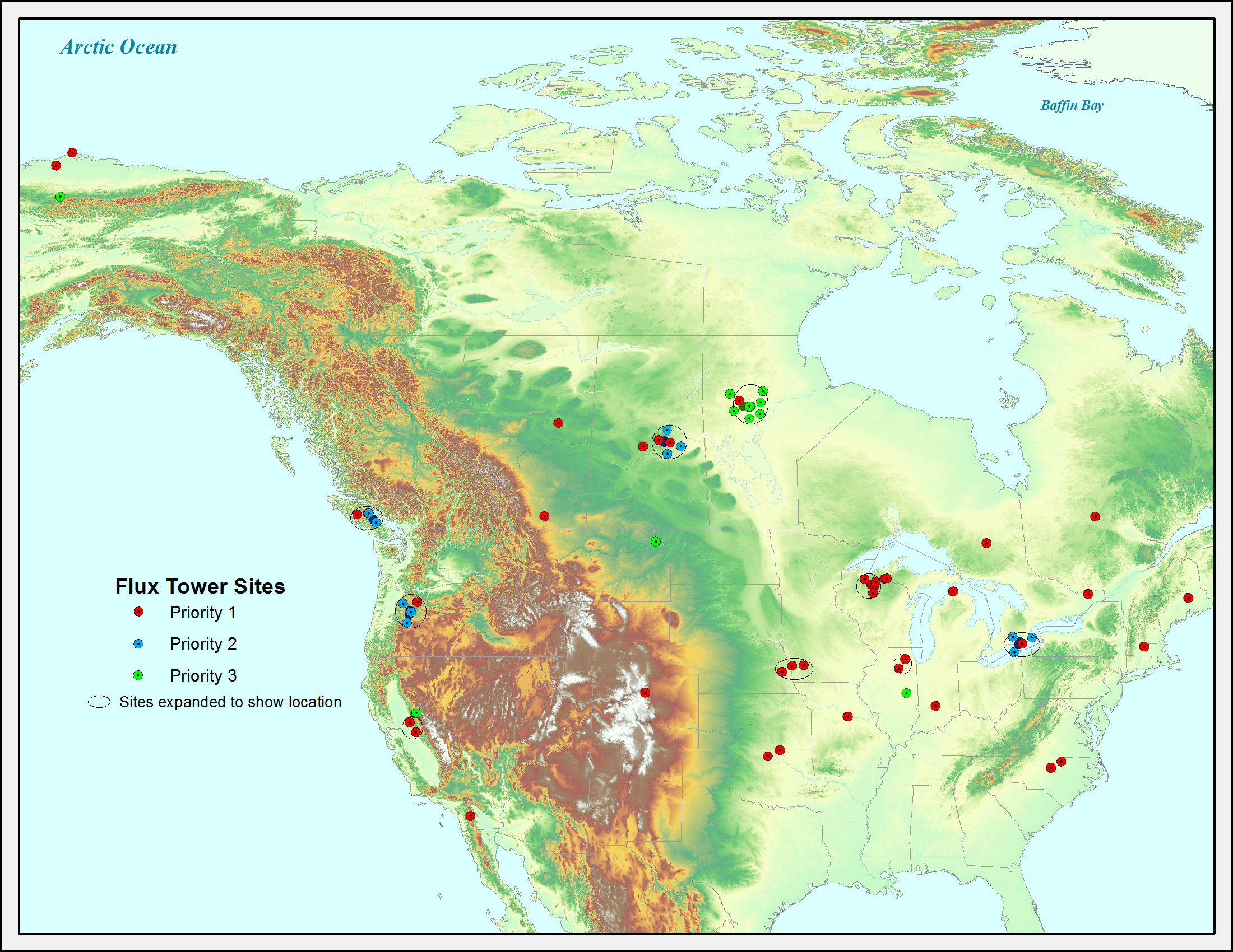
| Citation | Barr, A.G., D.M. Ricciuto, K. Schaefer, A. Richardson, D. Agarwal, P.E. Thornton, K.J. Davis, R.B. Cook, D.Y. Hollinger, C. van Ingen, B. Amiro, A.E. Andrews, M.A. Arain, D. Baldocchi, T.A. Black, P. Bolstad, P. Curtis, A. Desai, D. Dragoni, L. Flanagan, L. Gu, G. Katul, B.E. Law, P.M. Lafleur, H. Margolis, R. Matamala, T. Meyers, J.H. McCaughey, R. Monson, J.W. Munger, W. Oechel, R. Oren, N.T. Roulet, M. Torn, and S.B. Verma. 2013. NACP Site: Tower Meteorology, Flux Observations with Uncertainty, and Ancillary Data. ORNL DAAC, Oak Ridge, Tennessee, USA. http://dx.doi.org/10.3334/ORNLDAAC/1178 |
| Graphic Preview Description | Browse Image |
| Graphic Preview File | https://daac.ornl.gov/graphics/browse/project/square/nacp_logo_square.png |
| Harvest Object Id | 9c1b4b28-2c6b-4088-bcd0-e94378e153e3 |
| Harvest Source Id | 58f92550-7a01-4f00-b1b2-8dc953bd598f |
| Harvest Source Title | NASA Data.json |
| Homepage URL | https://doi.org/10.3334/ORNLDAAC/1178 |
| Metadata Type | geospatial |
| Old Spatial | -157.41 33.37 -68.74 71.32 |
| Program Code | 026:001 |
| Source Datajson Identifier | True |
| Source Hash | a261a7515c07405eedfca5469b11eafec8497e96a67712658ecf4e4d008fd551 |
| Source Schema Version | 1.1 |
| Spatial | |
| Temporal | 1991-01-01T00:00:00Z/2007-12-31T23:59:59Z |
Didn't find what you're looking for? Suggest a dataset here.