ABoVE/ASCENDS: Merged Atmospheric CO2, CH4, and Meteorological Data, 2017
Access & Use Information
Downloads & Resources
-
Google Scholar search resultsHTML
Search results for publications that cite this dataset by its DOI.
-
Download this datasetHTML
This link allows direct data access via Earthdata login
-
View documentation related to this datasetHTML
ORNL DAAC Data Set Documentation
-
This dataset's landing pageHTML
Data set Landing Page DOI URL
-
View documentation related to this datasetPDF
ABoVE/ASCENDS: Merged Atmospheric CO2, CH4, and Meteorological Data, 2017:...
-
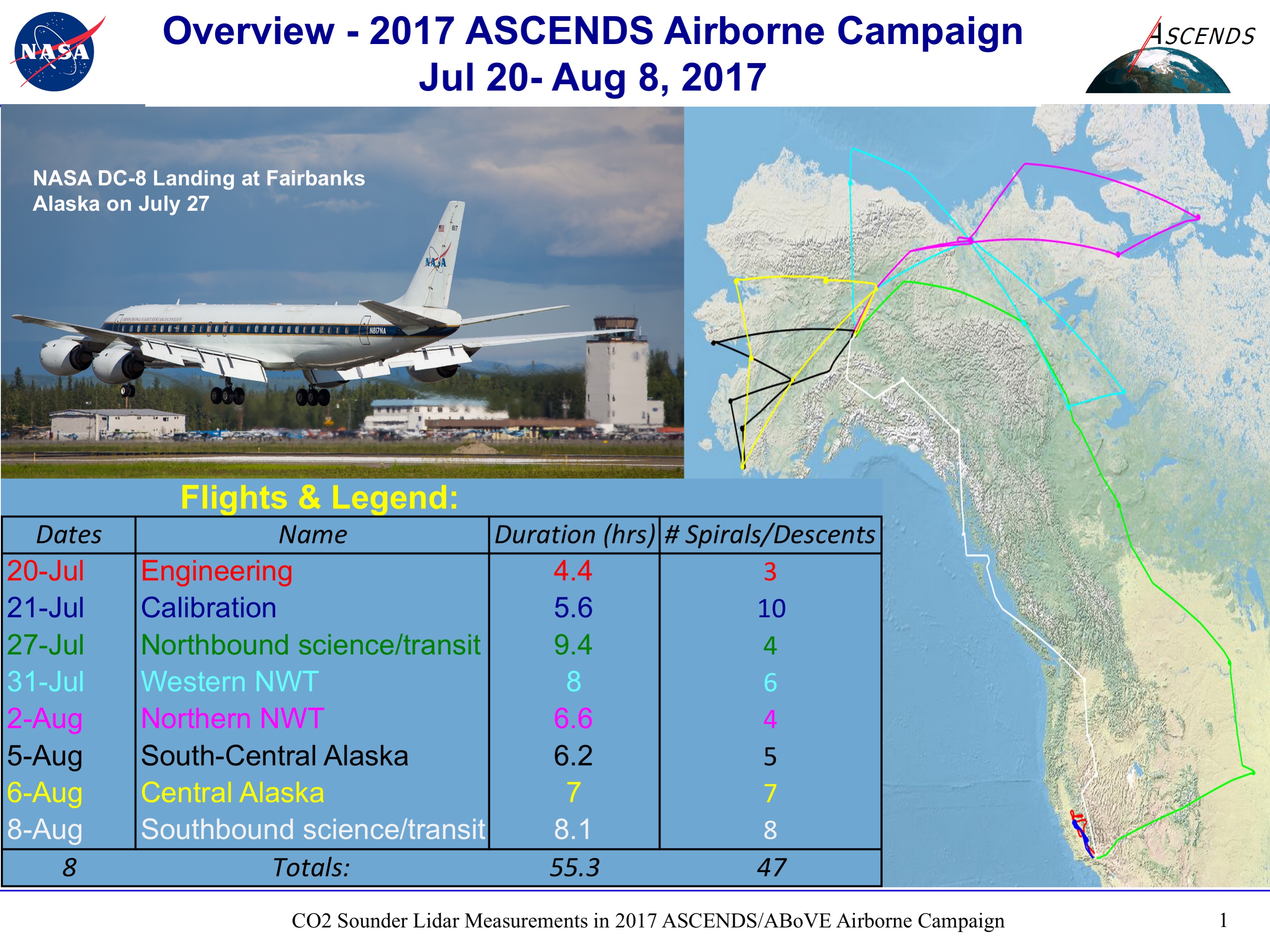
Get a related visualizationPNG
A map showing the ground tracks for the airborne campaign with a table...
-
The dataset's project home pageHTML
ABoVE project site
-
Landing PageLanding Page
Dates
| Metadata Created Date | May 30, 2023 |
|---|---|
| Metadata Updated Date | December 7, 2023 |
Metadata Source
- Data.json Data.json Metadata
Harvested from NASA Data.json
Graphic Preview

Additional Metadata
| Resource Type | Dataset |
|---|---|
| Metadata Created Date | May 30, 2023 |
| Metadata Updated Date | December 7, 2023 |
| Publisher | ORNL_DAAC |
| Maintainer | |
| Identifier | C2575399701-ORNL_CLOUD |
| Data First Published | 2023-02-09 |
| Language | en-US |
| Data Last Modified | 2023-06-12 |
| Category | ABoVE, ASCENDS Airborne, geospatial |
| Public Access Level | public |
| Bureau Code | 026:00 |
| Metadata Context | https://project-open-data.cio.gov/v1.1/schema/catalog.jsonld |
| Metadata Catalog ID | https://data.nasa.gov/data.json |
| Schema Version | https://project-open-data.cio.gov/v1.1/schema |
| Catalog Describedby | https://project-open-data.cio.gov/v1.1/schema/catalog.json |
| Citation | Abshire, J.B., J. Mao, H. Riris, S.R. Kawa, and X. Sun. 2022. ABoVE/ASCENDS: Merged Atmospheric CO2, CH4, and Meteorological Data, 2017. ORNL DAAC, Oak Ridge, Tennessee, USA. https://doi.org/10.3334/ORNLDAAC/2114 |
| Graphic Preview Description | A map showing the ground tracks for the airborne campaign with a table summarizing each flight. The colors in the table match those shown in the ground tracks. Image is from the related dataset Abshire et al. (2022). |
| Graphic Preview File | https://daac.ornl.gov/ABOVE/guides/ABoVE_ASCENDS_Merge_Fig1.png |
| Harvest Object Id | 303820e4-c61d-4fa3-a5bd-7f3696014d79 |
| Harvest Source Id | 58f92550-7a01-4f00-b1b2-8dc953bd598f |
| Harvest Source Title | NASA Data.json |
| Homepage URL | https://doi.org/10.3334/ORNLDAAC/2114 |
| Metadata Type | geospatial |
| Old Spatial | -165.68 34.59 -98.15 71.27 |
| Program Code | 026:001 |
| Source Datajson Identifier | True |
| Source Hash | 16984e5b00e578e048c15a48d6e3972682ca9d1c32b0f293a14315f43091c643 |
| Source Schema Version | 1.1 |
| Spatial | |
| Temporal | 2017-07-20T20:58:24Z/2017-08-09T00:35:59Z |
Didn't find what you're looking for? Suggest a dataset here.

