

20 datasets found for "k44텔레popkonDB)성인pc게임디비상담l"
-
Federal
2023 National Offshore Wind data set (NOW-23)
Department of Energy —
The 2023 National Offshore Wind data set (NOW-23) is the latest wind resource data set for offshore regions in the United States, which supersedes, for its offshore... -
Federal
LLMs for EV Infrastructure Permitting
Department of Energy —
The Electric Vehicle (EV) charging permitting processes' database is a novel, multi-jurisdictional resource designed to contain the required codes and compliances in... -
Federal
EGS Collab Experiment 2: Preliminary Test Wells Locations and Orientations
Department of Energy —
The EGS Collab project is evaluating a site for Experiment 2 (hydraulic fracturing/shearing) at a depth of 1.25 km in the Sanford Underground Research Facility (SURF)... -
Federal
EGS Collab Experiment 2: Laser Scanned 4100 L Drift Map
Department of Energy —
The EGS Collab project is evaluating a site for Experiment 2 (hydraulic fracturing/shearing) at a depth of 1.25 km in the Sanford Underground Research Facility (SURF)... -
Federal
UNH TDP - Concurrent Measurements of Inflow, Power Performance, and Loads for a Grid-Synchronized Vertical Axis Cross-Flow Turbine Operating in a Tidal Estuary
Department of Energy —
This data was collected between October 12 and December 15 of 2021 at the University of New Hampshire (UNH) and Atlantic Marine Energy Center (AMEC) turbine... -
Federal
Utah FORGE: Seismic Velocity Models, February 2021
Department of Energy —
This dataset contains a map, showing the Utah FORGE seismic stations, and seismic velocity model data. There are 61 1-D velocity models which are in a compressed TAR... -
Federal
USU Camas-1 Test Well: Documentation
Department of Energy —
This submission contains documents that describe the USU Camas-1 test well, drilled in Camas Prairie, Idaho, in Fall 2018 and Fall 2019. The purpose of this well is... -
Federal
Snake River Plain Geothermal Play Fairway Analysis Heat, Permeability, and Seal CRS Map Raster Files
Department of Energy —
Snake River Plain Play Fairway Analysis - Phase 1 CRS Raster Files. This dataset contains raster files created in ArcGIS. These raster images depict Common Risk... -
Federal
In-Situ Blade Strain Measurements of a Crossflow Turbine Operating in a Tidal Flow
Department of Energy —
This data was collected between October 25 and December 12 of 2022 at the University of New Hampshire (UNH) and Atlantic Marine Energy Center (AMEC) turbine... -
Federal
Deep Direct-Use Feasibility Study Temperature-Depth Estimates for West Virginia University, Morgantown, WV
Department of Energy —
This dataset contains data spreadsheets and figures that summarize the results of a stochastic analysis of temperatures at depth below the West Virginia University... -
Federal
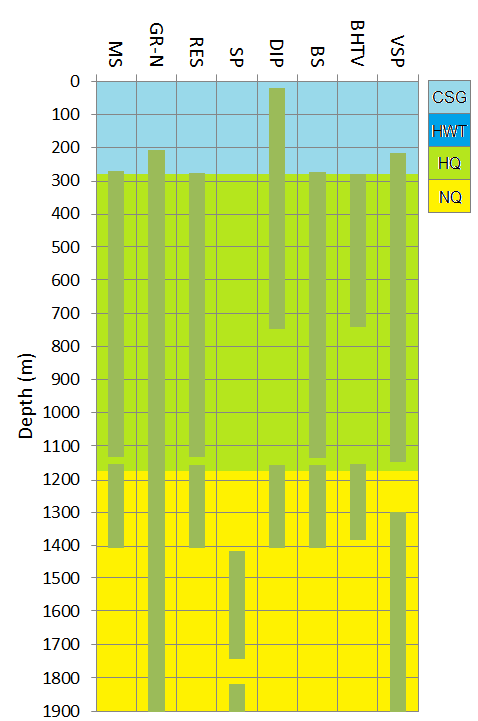
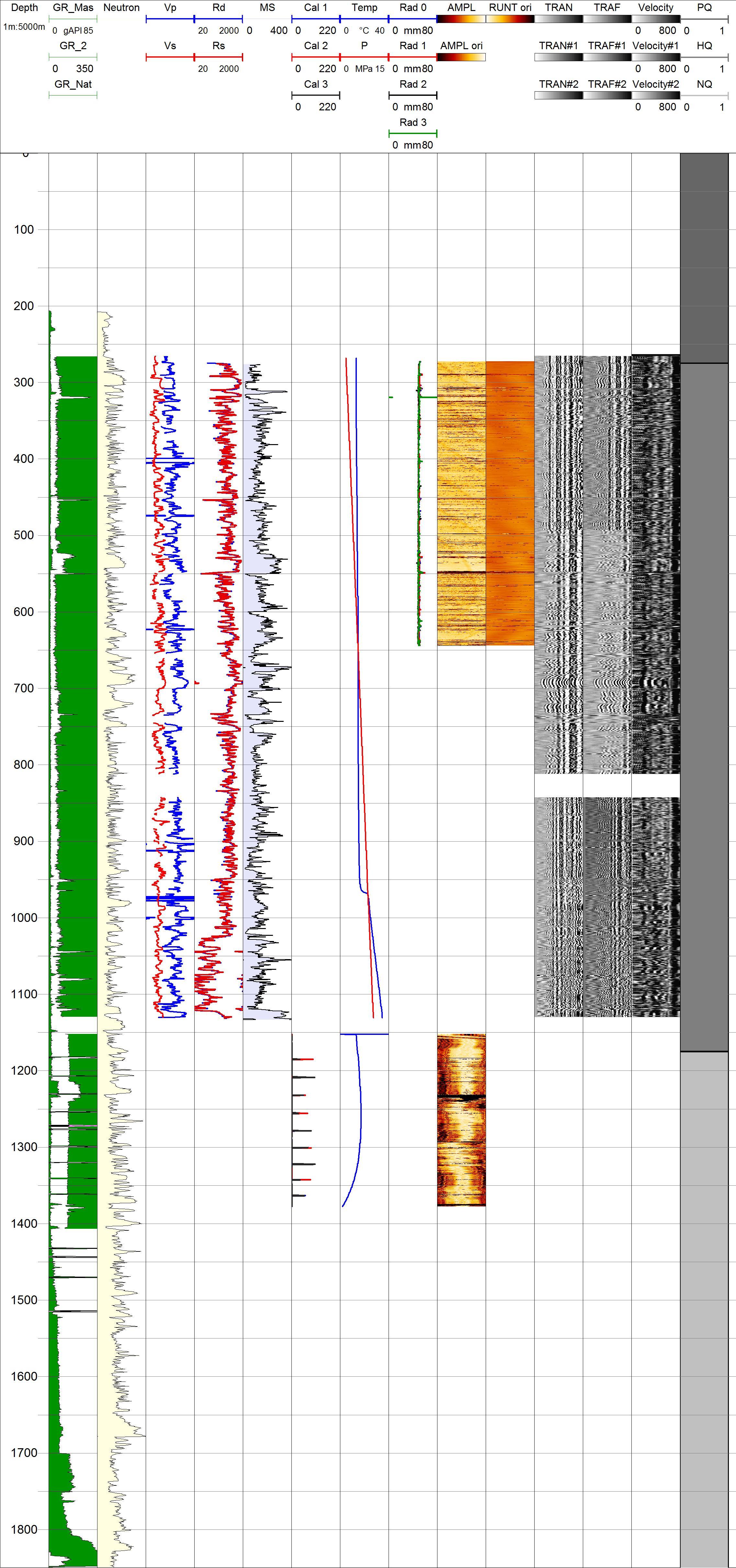
Project HOTSPOT: Kimama Well Borehole Geophysics Database
Department of Energy —
The Snake River Plain (SRP), Idaho, hosts potential geothermal resources due to elevated groundwater temperatures associated with the thermal anomaly Yellowstone-... -
Federal
EGS Collab Experiment 2: Core Logs
Department of Energy —
Core logs and photos from the EGS Collab project Experiment 2 for the Top Vertical well (TV4100) and the Top Horizontal well (TV 4100) on the 4100 Level of SURF (the... -
Federal
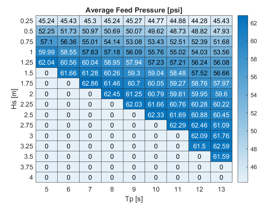
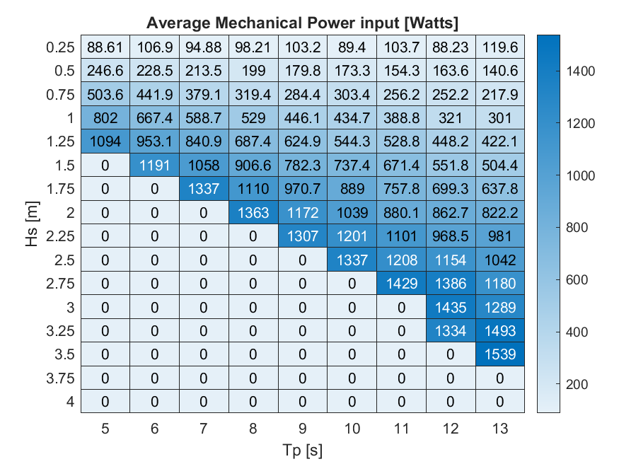
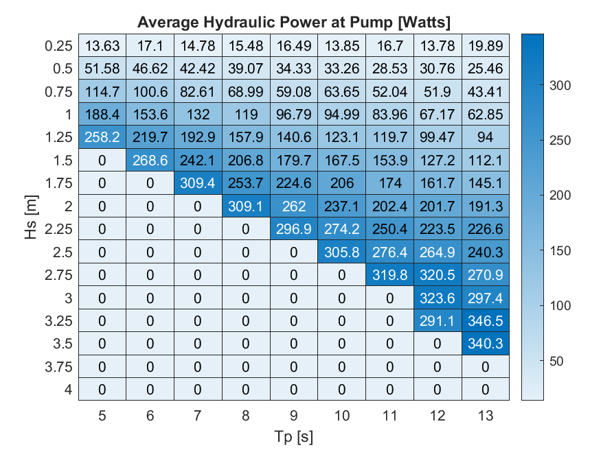
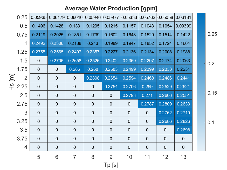
HERO WEC V1.0 - WEC-Sim Detailed Simulation Runs and Summary Data
Department of Energy —
Data sets from simulation runs include 144 wave cases that were run based on the WEC-Sim model (https://mhkdr.openei.org/submissions/483). The 144 wave cases... -
Federal
Snake River Plain Geothermal Play Fairway Analysis Project Active Source Seismic Data
Department of Energy —
This archive contains seismic shot field records for 10 profiles located in Camas Prairie, Idaho. The eight numbered .sgy files were acquired using a seismic land... -
Federal
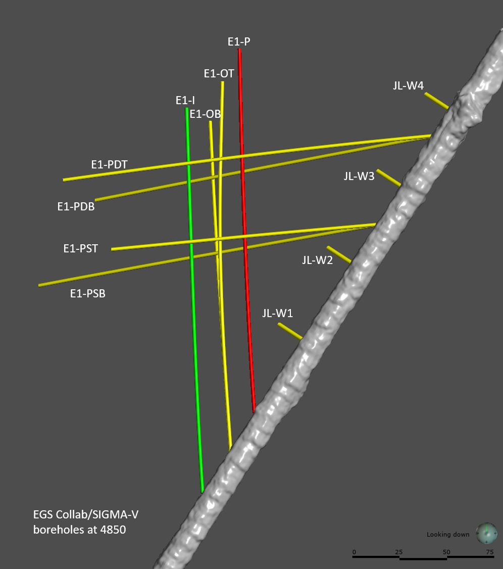
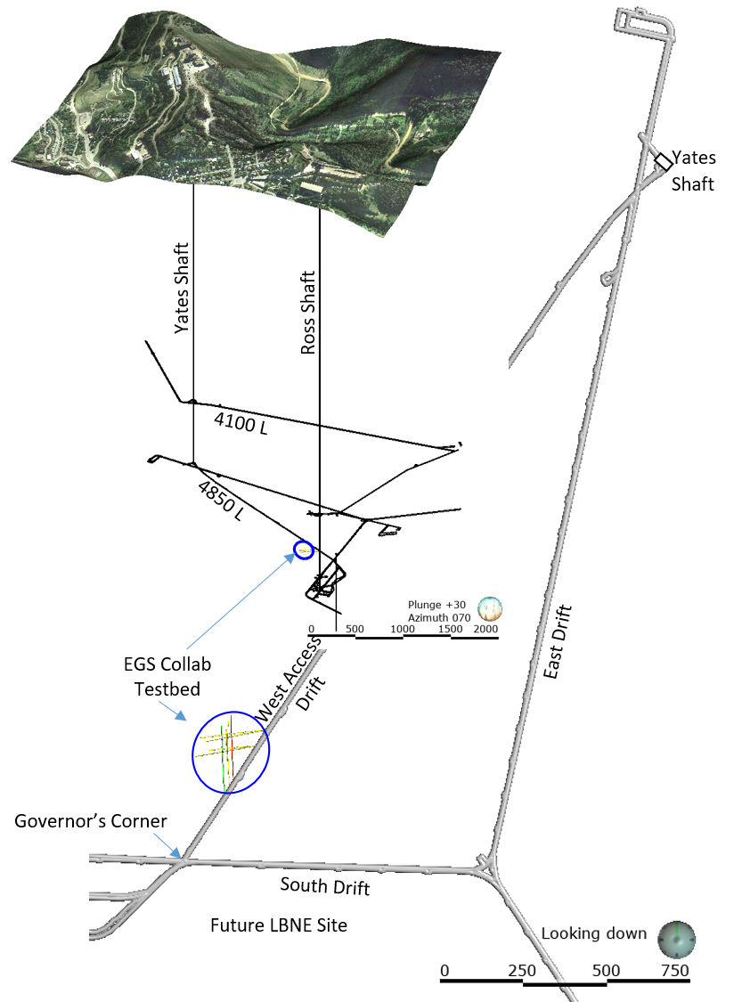
EGS Collab Experiment 1: Well Locations and Orientations.
Department of Energy —
The EGS Collab is conducting experiments in hydraulic fracturing at a depth of 1.5 km in the Sanford Underground Research Facility (SURF) on the 4850 Level. A total... -
Federal
Kilauea Magnetotelluric Dataset
Department of Energy —
In 2002 and 2003 a collaborative effort was undertaken between Lawrence Berkeley National Laboratory, Sandia National Laboratories, the USGS Menlo Park, the USGS... -
Federal
Total Sky Imager (TSI): cloud decision images, PNG format
Department of Energy —
No description found
20 datasets found for "k44텔레popkonDB)성인pc게임디비상담l"