

40 datasets found for "waste management"
-
Trash and Recycling Collection Points
District of Columbia —
The DPW Point of Collection datasets provide comprehensive information essential for managing waste and recycling services. These datasets include detailed geographic... -
State
Surface Water Quality Lines
State of Connecticut —
See full Data Guide here. Surface Water Quality Classifications Set: This dataset is a line and a polygon feature-based layer compiled at 1:24,000 scale that includes... -
Federal
Cleanups In My Community (CIMC) - Federal Facility RCRA Sites, National Layer
U.S. Environmental Protection Agency —
Federal facilities are properties owned by the federal government. This data layer provides access to Federal facilities that are Resource Conservation and Recovery... -
Federal
Cleanups In My Community (CIMC) - RCRA and Base Realignment and Closure (BRAC) Federal Facilities, National Layer
U.S. Environmental Protection Agency —
This data layer provides access to Resource Conservation and Recovery Act (RCRA) Base Realignment and Closure (BRAC) sites as part of the CIMC web service. The... -
City
Jefferson County KY Urban Heat Management Study
Louisville Metro Government —
Click here to view the Metro Office of Sustainability web site about this study and here to view the complete report.This data includes a land cover assessment for... -
State
Warden Districts
Vermont Center for Geographic Information —
The Vermont Warden Districts layer is part of a dataset that contains administrative boundaries for Vermont's Agency of Natural Resources. The dataset includes... -
State
Food Scrap Generators
Vermont Center for Geographic Information —
Here you will find Vermont businesses and institutions (such as restaurants, grocery stores, markets, hospitals, schools, food manufacturers, assisted living... -
State
Surface Water Quality Classifications Set
State of Connecticut —
See full Data Guide here. Surface Water Quality Classifications Set: This dataset is a line and a polygon feature-based layer compiled at 1:24,000 scale that includes... -
RiverSmart Homes
District of Columbia —
RiverSmart Homes is a program of the District of Columbia offering incentives to residents to reduce stormwater runoff from their properties. Residents receive a... -
State
Park Districts
Vermont Center for Geographic Information —
The Parks Districts layer is part of a dataset contains administrative boundaries for Vermont's Agency of Natural Resources. The dataset includes feature classes for... -
Federal
U.S. EPA National Priorities List (NPL) Sites Point Data with CIESIN Modifications, Version 2
National Aeronautics and Space Administration —
The U.S. Environmental Protection Agency (EPA) National Priorities List (NPL) Sites Point Data with CIESIN Modifications, Version 2 is a modified version of the 2014... -
Federal
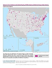
ATSDR Hazardous Waste Site Polygon Data, Version 2
National Aeronautics and Space Administration —
The Agency for Toxic Substances and Disease Registry (ATSDR) Hazardous Waste Site Polygon Data, Version 2 consists of 2,080 polygons for selected hazardous waste... -
Federal
Effects of water quality on non-coral communities: surveys of macroinvertebrates, benthic microalgae, and benthic foraminifera at sites along a water quality gradient in Aua, American Samoa in 2022
National Oceanic and Atmospheric Administration, Department of Commerce —
This metadata record describes the non-coral bioindicator datasets funded by the NOAA Coral Reef Conservation Program (CRCP) Project Number 31303 to study effects of... -
State
Watershed Planning Basins
Vermont Center for Geographic Information —
The Watershed Planning Basin layer is part of a larger dataset contains administrative boundaries for Vermont's Agency of Natural Resources. The dataset includes... -
State
Landfills
Vermont Center for Geographic Information —
This data set defines both current and historic landfills/waste disposal storage sites for the State of Vermont. Historic landfills were identified with the... -
Federal
Cleanups In My Community (CIMC) - Federal facilities that are also Superfund sites, National Layer
U.S. Environmental Protection Agency —
Federal facilities are properties owned by the federal government. This data layer provides access to Federal facilities that are Superfund sites as part of the CIMC... -
Federal
Compendium of Environmental Sustainability Indicator Collections: 2006 National Footprint Accounts (NFA)
National Aeronautics and Space Administration —
The 2006 National Footprint Accounts (NFA) portion of the Compendium of Environmental Sustainability Indicator Collections, version 1.1 is a data set that measures... -
Green Infrastructure Practices in the District
District of Columbia —
Stormwater runoff carries harmful pollutants like pet waste, oil, grease, sediment, and litter into the District of Columbia’s waterbodies through storm drains or...
40 datasets found for "waste management"