
-
Federal
School Neighborhood Poverty Estimates - Current
Department of Education —
The 2020-2021 School Neighborhood Poverty Estimates are based on school locations from the 2020-2021 Common Core of Data (CCD) school file and income data from... -
City
Racial and Social Equity Composite Index Current for Countywide Comparisons
City of Seattle —
!!PLEASE NOTE!! When downloading the data, please select "File Geodatabase" to preserve long field names. Shapefile will truncate field names to 10 characters.This... -
Exposure Activities Event Distance Trends
District of Columbia —
Retired on March 2, 2022. Data and metadata are provided as-is archive.The “Event Distancing Trend” indicates the number of positive cases interviewed per week who... -
Federal
School Neighborhood Poverty Estimates, 2020-21
Department of Education —
The 2020-2021 School Neighborhood Poverty Estimates are based on school locations from the 2020-2021 Common Core of Data (CCD) school file and income data from... -
Federal
Time-Series Data on the Ocean and Great Lakes Economy for Counties, States, and the Nation between 2005 and 2019 (Sector Level)
National Oceanic and Atmospheric Administration, Department of Commerce —
Economics: National Ocean Watch (ENOW) contains annual time-series data for over 400 coastal counties, 30 coastal states, 8 regions, and the nation, derived from the... -
University
HSIP Hospitals in New Mexico
Earth Data Analysis Center, University of New Mexico —
Hospitals in New Mexico The term "hospital" ... means an institution which- (1) is primarily engaged in providing, by or under the supervision of physicians, to... -
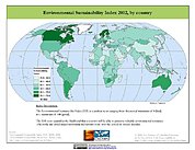
Federal
2002 Environmental Sustainability Index (ESI)
National Aeronautics and Space Administration —
The 2002 Environmental Sustainability Index (ESI) measures overall progress toward environmental sustainability for 142 countries based on environmental systems,... -
Federal
Social Vulnerability Index (SoVI) for South Carolina based on 2000 Census Block Groups
National Oceanic and Atmospheric Administration, Department of Commerce —
This data depicts the social vulnerability of South Carolina census block groups to environmental hazards. Data were culled primarily from the 2000 Decennial Census. -
Federal
School Neighborhood Poverty Estimates, 2016-17
Department of Education —
The 2016-2017 School Neighborhood Poverty Estimates are based on school locations from the 2016-2017 Common Core of Data (CCD) school file and income data from... -
City
Louisville Metro KY - List of Locations with COVID Related Cease Operation Order
Louisville Metro Government —
This is a list of locations of which the following conditions apply:ACTIVITY TYPE ID 12 Enforcement Action – Action Code Z – The establishment has been issued an... -
Federal
NCCOS Assessment: Prescribed Fire in Coastal Alabama and Mississippi, 1992-01-01 to 2022-12-31
National Oceanic and Atmospheric Administration, Department of Commerce —
This dataset includes smoke and prescribed fire density from the National Centers for Coastal Ocean Science (NCCOS) Social Science team's Prescribed Fire project in... -
Federal
School Neighborhood Poverty Estimates - Current
Department of Education —
The 2020-2021 School Neighborhood Poverty Estimates are based on school locations from the 2020-2021 Common Core of Data (CCD) school file and income data from... -
Federal
ACS-ED 2014-2018 Children-Enrolled Public: Social Characteristics (CDP02)
Department of Education —
The American Community Survey Education Tabulation (ACS-ED) is a custom tabulation of the ACS produced for the National Center of Education Statistics (NCES) by the... -
University
Land-Use Conflict Identification Strategy (LUCIS) Models
University of Idaho —
The downloadable ZIP file contains model documentation and contact information for the model creator. For more information, or a copy of the project report which... -
Federal
ACS-ED 2013-2017 Total Population: Demographic Characteristics (DP05)
Department of Education —
The American Community Survey Education Tabulation (ACS-ED) is a custom tabulation of the ACS produced for the National Center of Education Statistics (NCES) by the... -
Federal
ACS-ED 2014-2018 Children-Enrolled Public: Social Characteristics (CDP02)
Department of Education —
The American Community Survey Education Tabulation (ACS-ED) is a custom tabulation of the ACS produced for the National Center of Education Statistics (NCES) by the... -
Federal
School Neighborhood Poverty Estimates, 2018-19
Department of Education —
The 2018-2019 School Neighborhood Poverty Estimates are based on school locations from the 2018-2019 Common Core of Data (CCD) school file and income data from... -
Federal
Social Vulnerability Index (SoVI) for Texas based on 2000 Census Block Groups
National Oceanic and Atmospheric Administration, Department of Commerce —
This data depicts the social vulnerability of Texas census block groups to environmental hazards. Data were culled primarily from the 2000 Decennial Census. -
City
Louisville Metro KY - Homelessness Task Force Planning Table
Louisville Metro Government —
This data is no longer being actively updated. The dataset is deprecated and will be removed from the Portal within the next three months. If you have any questions,... -
Federal
Social Vulnerability Index (SoVI) for New Jersey based on 2000 Census Block Groups
National Oceanic and Atmospheric Administration, Department of Commerce —
This data depicts the social vulnerability of New Jersey census block groups to environmental hazards. Data were culled primarily from the 2000 Decennial Census.

Official websites use .gov
A
.gov website belongs to an official government
organization in the United States.
Secure .gov websites use HTTPS
A
lock (
) or https:// means you’ve safely connected to
the .gov website. Share sensitive information only on official,
secure websites.