
-
Federal
ASTER Global DEM NGDA
National Aeronautics and Space Administration —
ASTER is capable of collecting in-track stereo using nadir- and aft-looking near infrared cameras. Since 2001, these stereo pairs have been used to produce single-... -
City
Louisville Metro KY - Pool Inspections
Louisville Metro Government —
Routine reinspection of over 537 public pools and treated water aquatic facilities in the US State of Kentucky, totalling over 2,000 inspections per year.... -
Federal
Mexico Geoid Heights (MEXICO97)
National Oceanic and Atmospheric Administration, Department of Commerce —
This 2' geoid height grid for Mexico, and North-Central America, is the MEXICO97 geoid model. The computation used about one million terrestrial and marine gravity... -
Federal
Age, spreading rates, and spreading asymmetry of the world's ocean crust
National Oceanic and Atmospheric Administration, Department of Commerce —
The authors present four companion digital models of the age, age uncertainty, spreading rates and spreading asymmetries of the world's ocean basins as geographic and... -
Federal
Deepwater Horizon MC252 GIS data from the Environmental Response Management Application (ERMA) collected and/or used during the DWH response between 1989-11-15 and 2015-11-30 in the Northern Gulf of Mexico
National Oceanic and Atmospheric Administration, Department of Commerce —
This collection contains Environmental Response Management Application (ERMA) GIS layers used as part of the Programmatic Damage Assessment and Restoration Plan... -
Federal
Magnetic Anomaly Data for the Former Soviet Union
National Oceanic and Atmospheric Administration, Department of Commerce —
In 1974, the Ministry of Geology of the U.S.S.R. published a mosaic series of 18 sheets at 1:2.5 million scale showing the residual magnetic intensity over the land... -
Federal
Precipitation Reconstruction (PREC)
National Oceanic and Atmospheric Administration, Department of Commerce —
The PREC data set is an analysis of monthly precipitation constructed on a 2.5° lat/lon grid over the global for the period from 1948 to the present. The land... -
Federal
Nevada Isostatic Residual Gravity Over Basement
National Oceanic and Atmospheric Administration, Department of Commerce —
This study of gravity data from Nevada is part of a statewide analysis of mineral resources. The main objective of the gravity study were: 1) to infer the structure... -
Federal
Global Annual PM2.5 Grids from MODIS, MISR, SeaWiFS and VIIRS Aerosol Optical Depth (AOD), 1998-2022, V5.GL.04 NGDA
National Aeronautics and Space Administration —
The Global Annual PM2.5 Grids from MODIS, MISR, SeaWiFS and VIIRS Aerosol Optical Depth (AOD), 1998-2022, V5.GL.04 consists of annual concentrations (micrograms per... -
Federal
Data and code from: Virome of <i>Solenopsis invicta</i> (Hymenoptera: Formicidae): intercontinental differences in the native and introduced ranges
Department of Agriculture —
This dataset contains all the raw data and R statistical software code needed to reproduce the maps and statistical analyses presented in the associated manuscript,... -
Federal
UW157-20150917T1833
National Oceanic and Atmospheric Administration, Department of Commerce —
Seaglider SG157 Trinidad Head IOOS line, California -
Federal
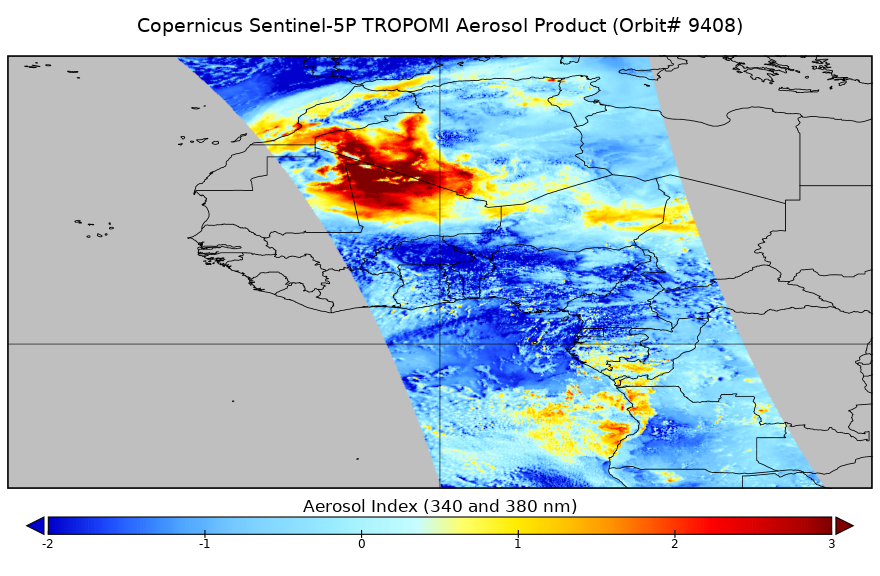
Sentinel-5P TROPOMI Near-Real-Time (NRT) Aerosol Index 1-Orbit L2 5.5km x 3.5km V2 (S5P_L2__AER_AI_HiR_NRT) at GES DISC
National Aeronautics and Space Administration —
The Sentinel-5P TROPOMI Near Real Time (NRT) Aerosol Index 1-Orbit L2 5.5km x 3.5km V2 (S5P_L2__AER_AI_HiR_NRT) at GES DISC is the near real time version of the... -
Federal
The Reynolds Creek Long-Term Dataset: A long-term meteorological dataset derived from station observations in the Reynolds Creek Experimental Watershed
Department of Agriculture —
AbstractA forty-year gridded meteorological forcing dataset spanning the water years 1984 to 2023 (October 1st to September 30th) has been compiled for the Reynolds... -
Federal
Biomass Burning 5x5 degree data in Native Format
National Aeronautics and Space Administration —
The BIO_MASS_5X5_HAO_NAT data set contains data representing the geographical and temporal distribution of total amount of biomass burned. The data were collected by... -
Federal
Global Estimated Net Migration Grids by Decade: 1970-2000
National Aeronautics and Space Administration —
The Global Estimated Net Migration by Decade: 1970-2000 data set provides estimates of net migration over the three decades from 1970 to 2000. Because of the lack of... -
Federal
U.S. Isostatic Residual Gravity Grid
National Oceanic and Atmospheric Administration, Department of Commerce —
isores.bin - standard grid containing isostatic residual gravity map for U.S. Grid interval = 4 km. Projection is Albers (central meridian = 96 degrees West; base... -
Federal
Global Annual PM2.5 Grids from MODIS, MISR and SeaWiFS Aerosol Optical Depth (AOD), 1998-2019, V4.GL.03 NGDA
National Aeronautics and Space Administration —
The Global Annual PM2.5 Grids from MODIS, MISR and SeaWiFS Aerosol Optical Depth (AOD), 1998-2019, V4.GL.03 consists of annual concentrations (micrograms per cubic... -
Federal
Nevada Thickness of Cenozoic Deposits
National Oceanic and Atmospheric Administration, Department of Commerce —
This study of gravity data from Nevada is part of a statewide analysis of mineral resources. The main objective of the gravity study were: 1) to infer the structure... -
Federal
Aeromagnetic Regional Grid Data
National Oceanic and Atmospheric Administration, Department of Commerce —
Several regions are represented in this unique collection of earth surface measurements of magnetic field parameters and their related anomalies. The DNAG Magnetics... -
Federal
Glider - Trinidad Head Line: 2015 September - 2016 May
National Oceanic and Atmospheric Administration, Department of Commerce —
Seaglider SG157 Trinidad Head IOOS line, California

Official websites use .gov
A
.gov website belongs to an official government
organization in the United States.
Secure .gov websites use HTTPS
A
lock (
) or https:// means you’ve safely connected to
the .gov website. Share sensitive information only on official,
secure websites.