
-
Federal
GPCP Precipitation Level 3 Daily 0.5-Degree V3.2 (GPCPDAY) at GES DISC recent views
National Aeronautics and Space Administration —
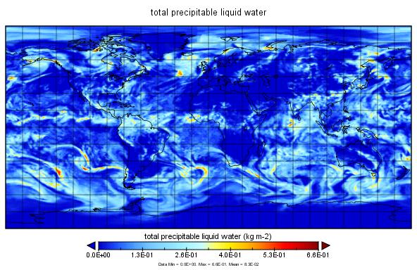
Version 3.2 is the current version. Older versions have been superseded by Version 3.2. The Global Precipitation Climatology Project (GPCP) is the precipitation... -
Federal
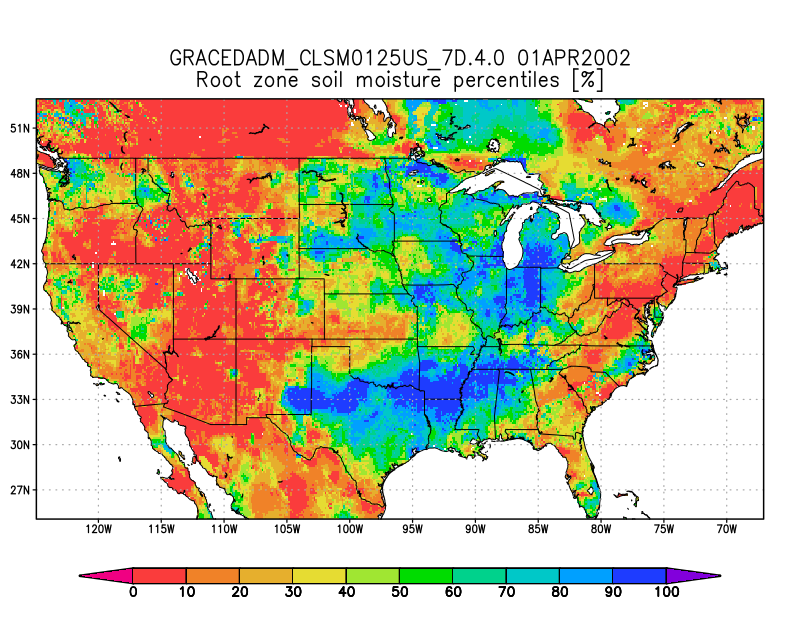
Groundwater and Soil Moisture Conditions from GRACE and GRACE-FO Data Assimilation L4 7-days 0.125 x 0.125 degree U.S. V4.0 (GRACEDADM_CLSM0125US_7D) at GES DISC recent views
National Aeronautics and Space Administration —
Scientists at NASA Goddard Space Flight Center generate groundwater and soil moisture drought indicators each week. They are based on terrestrial water storage... -
Federal
ISLSCP II Ecosystem Rooting Depths NGDA recent views
National Aeronautics and Space Administration —
The goal of this study was to predict the global distribution of plant rooting depths based on data about global aboveground vegetation structure and climate.... -
Federal
NLDAS Mosaic Land Surface Model L4 Hourly 0.125 x 0.125 degree V002 (NLDAS_MOS0125_H) at GES DISC recent views
National Aeronautics and Space Administration —
This data set contains a series of land surface parameters simulated from the Mosaic land-surface model (LSM) for Phase 2 of the North American Land Data Assimilation... -
Federal
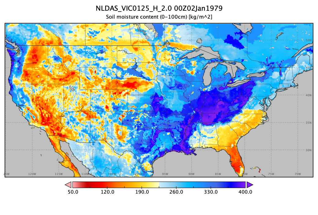
NLDAS VIC Land Surface Model L4 Hourly 0.125 x 0.125 degree V2.0 (NLDAS_VIC0125_H) at GES DISC recent views
National Aeronautics and Space Administration —
This data set contains forty-four fields simulated from the VIC land-surface model (LSM) for Phase 2 of the North American Land Data Assimilation System (NLDAS-2).... -
Federal
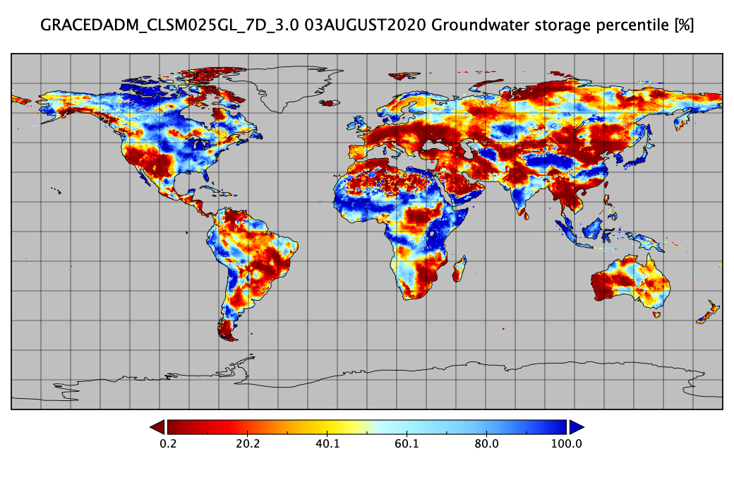
Groundwater and Soil Moisture Conditions from GRACE and GRACE-FO Data Assimilation L4 7-days 0.25 x 0.25 degree Global V3.0 (GRACEDADM_CLSM025GL_7D) at GES DISC recent views
National Aeronautics and Space Administration —
Scientists at NASA Goddard Space Flight Center generate groundwater and soil moisture drought indicators each week. They are based on terrestrial water storage... -
Federal
SatCORPS CERES GEO Edition 4 Meteosat-9 Southern Hemisphere Version 1.0 recent views
National Aeronautics and Space Administration —
CER_GEO_Ed4_MET09_SH_V01 is the Satellite Cloud and Radiation Property retrieval System (SatCORPS) Clouds and the Earth's Radiant Energy System (CERES) Geostationary... -
Federal
ECOSTRESS Gridded Surface Energy Balance Instantaneous L3 Global 70 m V002 recent views
National Aeronautics and Space Administration —
The ECOsystem Spaceborne Thermal Radiometer Experiment on Space Station (ECOSTRESS) mission measures the temperature of plants to better understand how much water... -
Federal
GPCP Precipitation Level 3 Daily 0.5-Degree V3.1 (GPCPDAY) at GES DISC recent views
National Aeronautics and Space Administration —
This version has been superseded by Version 3.2 (DOI: 10.5067/MEASURES/GPCP/DATA305). The Global Precipitation Climatology Project (GPCP) is the precipitation... -
Federal
Northern and Mid-Latitude Soil Database, Version 1, R1 recent views
National Aeronautics and Space Administration —
The U.S. Department of Agriculture, Agriculture and Agri-Food Canada, the Russian Academy of Agricultural Sciences, the University of Copenhagen Institute of... -
Federal
NRT AMSR2 Unified Global Swath Surface Precipitation GSFC Profiling Algorithm V2 recent views
National Aeronautics and Space Administration —
The Advanced Microwave Scanning Radiometer 2 (AMSR2) instrument on the Global Change Observation Mission - Water 1 (GCOM-W1) provides global passive microwave... -
Federal
ISLSCP II Global Sea Ice Concentration recent views
National Aeronautics and Space Administration —
This International Satellite Land Surface Climatology Project (ISLSCP) Initiative II data set, ISLSCP II Global Sea Ice Concentration, is based on the Goddard Space... -
Federal
HRIR/Nimbus-3 Level 1 Meteorological Radiation Data V001 (HRIRN3L1) at GES DISC recent views
National Aeronautics and Space Administration —
HRIRN3L1 is the High Resolution Infrared Radiometer (HRIR) Nimbus-3 Level 1 Meteorological Radiance Data (NMRT) product and contains infrared radiances converted to... -
Federal
SRB/GEWEX evapotranspiration (Penman-Monteith) L4 3 hour 0.5 degree x 0.5 degree V1 (WC_PM_ET_050) at GES DISC recent views
National Aeronautics and Space Administration —
SRB/GEWEX evapotranspiration (Penman-Monteith) L4 3 hour 0.5 degree x 0.5 degree V1 is a global, 24-year (1984-2007), satellite-derived evapotranspiration over land... -
Federal
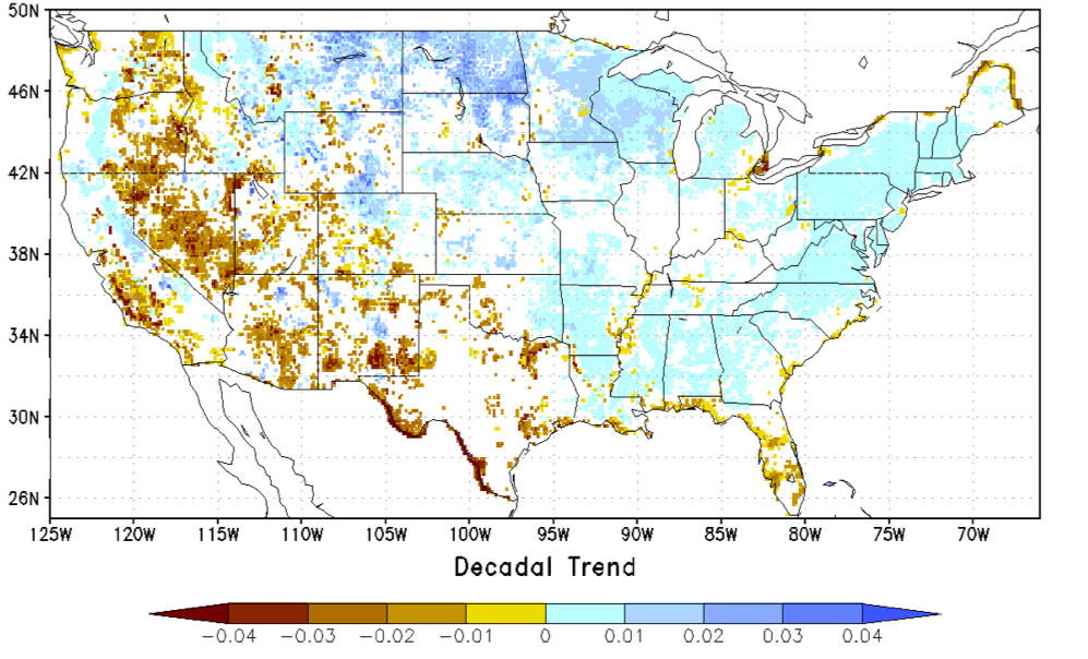
NCA-LDAS Noah-3.3 Land Surface Model L4 Trends 0.125 x 0.125 degree V2.0 (NCALDAS_NOAH0125_Trends) at GES DISC recent views
National Aeronautics and Space Administration —
The National Climate Assessment - Land Data Assimilation System, or NCA-LDAS, is a terrestrial water reanalysis in support of the United States Global Change Research... -
Federal
CERES Regionally Averaged Computed TOA, within the Atmosphere, and Surface Fluxes Hourly Terra Edition4A recent views
National Aeronautics and Space Administration —
CER_CRS1deg-Hour_Terra-MODIS_Edition4A is the Terra Clouds and the Earth's Radiant Energy System (CERES) Level 3 computed flux Edition4A data product. The Cloud and... -
Federal
MERRA-2 tavg1_2d_int_Nx: 2d,1-Hourly,Time-Averaged,Single-Level,Assimilation,Vertically Integrated Diagnostics 0.625 x 0.5 degree V5.12.4 (M2T1NXINT) at GES DISC recent views
National Aeronautics and Space Administration —
M2T1NXINT (or tavg1_2d_int_Nx) is an hourly time-averaged 2-dimensional data collection in Modern-Era Retrospective analysis for Research and Applications version 2... -
Federal
MERRA-2 inst1_2d_int_Nx: 2d,1-Hourly,Instantaneous,Single-Level,Assimilation,Vertically Integrated Diagnostics 0.625 x 0.5 degree V5.12.4 (M2I1NXINT) at GES DISC recent views
National Aeronautics and Space Administration —
M2I1NXINT (or inst1_2d_int_Nx) is an instantaneous 2-dimensional hourly data collection in Modern-Era Retrospective analysis for Research and Applications version 2... -
Federal
Aqua AIRS Level 2 JoSFRA Retrieval Standard: Atmosphere cloud and surface geophysical state per footprint V2 at GES DISC recent views
National Aeronautics and Space Administration —
The Joint Single Footprint Retrieval Algorithm (JoSFRA) Level-2 geophysical parameters include estimates of atmospheric temperature and water vapor profiles, cloud... -
Federal
LBA-ECO CD-32 Flux Tower Network Data Compilation, Brazilian Amazon: 1999-2006, V2 recent views
National Aeronautics and Space Administration —
This dataset is a compilation of carbon and energy eddy covariance flux, meteorology, radiation, canopy temperature, humidity, CO2 profiles and soil moisture and...

Official websites use .gov
A
.gov website belongs to an official government
organization in the United States.
Secure .gov websites use HTTPS
A
lock (
) or https:// means you’ve safely connected to
the .gov website. Share sensitive information only on official,
secure websites.