Aqua AIRS Level 2 JoSFRA Retrieval Standard: Atmosphere cloud and surface geophysical state per footprint V2 at GES DISC
Access & Use Information
Downloads & Resources
-
Google Scholar search resultsHTML
Search results for publications that cite this dataset by its DOI.
-
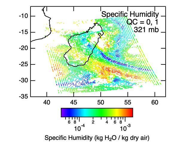
Get a related visualizationPNG
Sample image of JoSFRA Retrieval
-
This dataset's landing pageHTML
Access the dataset landing page from the GES DISC website.
-
Download this dataset through a directory mapHTML
Access the data via HTTPS.
-
Use OPeNDAP to access the dataset's dataHTML
Access the data via the OPeNDAP protocol.
-
Download this dataset through Earthdata SearchHTML
Use the Earthdata Search to find and retrieve data sets across multiple data...
-
The dataset's project home pageHTML
AIRS home page at NASA/JPL. General information on the AIRS...
-
View information related to this datasetHTML
AIRS Documentation Page
-
View this dataset's read me documentPDF
README for JOSFRA L2 V2
-
View this dataset's algorithm theoretical...PDF
JoSFRA_V2_ATBD.pdf
-
View this dataset's data quality documentPDF
JoSFRA_V2_Test_Report.pdf
-
Landing PageLanding Page
References
| https://doi.org/10.1029/2005/JD007020 |
Dates
| Metadata Created Date | April 8, 2024 |
|---|---|
| Metadata Updated Date | April 8, 2024 |
Metadata Source
- Data.json Data.json Metadata
Harvested from NASA Data.json
Graphic Preview

Additional Metadata
| Resource Type | Dataset |
|---|---|
| Metadata Created Date | April 8, 2024 |
| Metadata Updated Date | April 8, 2024 |
| Publisher | NASA/GSFC/SED/ESD/GCDC/GESDISC |
| Maintainer | |
| Identifier | C2788811366-GES_DISC |
| Data First Published | 2023-10-23 |
| Language | en-US |
| Data Last Modified | 2023-10-23 |
| Category | Aqua, geospatial |
| Public Access Level | public |
| Bureau Code | 026:00 |
| Metadata Context | https://project-open-data.cio.gov/v1.1/schema/catalog.jsonld |
| Metadata Catalog ID | https://data.nasa.gov/data.json |
| Schema Version | https://project-open-data.cio.gov/v1.1/schema |
| Catalog Describedby | https://project-open-data.cio.gov/v1.1/schema/catalog.json |
| Citation | Fredrick W. Irion and the AIRS Project. 2023-10-24. SNDRAQIL2JSFRET. Version 2. Aqua AIRS Level 2 JoSFRA Retrieval Standard: Atmosphere cloud and surface geophysical state per footprint. Greenbelt, MD, USA. Archived by National Aeronautics and Space Administration, U.S. Government, Goddard Earth Sciences Data and Information Services Center (GES DISC). https://doi.org/10.5067/0K06YE0Y8IDS. https://disc.gsfc.nasa.gov/datacollection/SNDRAQIL2JSFRET_2.html. Digital Science Data. |
| Creator | Fredrick W. Irion and the AIRS Project |
| Data Presentation Form | Digital Science Data |
| Graphic Preview Description | Sample image of JoSFRA Retrieval |
| Graphic Preview File | https://docserver.gesdisc.eosdis.nasa.gov/public/project/Images/SampleImageSNDRAQIL2JSFRET_2.png |
| Harvest Object Id | b0dd8eb0-87c6-452f-8fae-f03fa2b0cdfc |
| Harvest Source Id | 58f92550-7a01-4f00-b1b2-8dc953bd598f |
| Harvest Source Title | NASA Data.json |
| Homepage URL | https://doi.org/10.5067/0K06YE0Y8IDS |
| Metadata Type | geospatial |
| Old Spatial | -180.0 -90.0 180.0 90.0 |
| Program Code | 026:001 |
| Related Documents | https://doi.org/10.1029/2005/JD007020 |
| Release Place | Greenbelt, MD, USA |
| Series Name | SNDRAQIL2JSFRET |
| Source Datajson Identifier | True |
| Source Hash | 372c5ca290c3a61e9fa263529eac7b62943732a692c6835f8a4c2d4169ae63a4 |
| Source Schema Version | 1.1 |
| Spatial | |
| Temporal | 2002-08-30T00:00:00Z/2024-04-08T00:00:00Z |
Didn't find what you're looking for? Suggest a dataset here.

