
-
Federal
SPURS-2 Passive Accoustic Listener (PAL) data from ARGO float deployments during the E. Tropical Pacific field campaign recent views
National Aeronautics and Space Administration —
The SPURS (Salinity Processes in the Upper Ocean Regional Study) project is a NASA-funded oceanographic process study and associated field program that aim to... -
Federal
SWOT Level 2 Radiometer Brightness Temperatures and Troposphere Interim Data Product Version 1.0 recent views
National Aeronautics and Space Administration —
The SWOT Level 2 Radiometer Brightness Temperatures and Troposphere Interim Geophysical Data Record (IGDR) Version 1.0 dataset produced by the Surface Water and Ocean... -
Federal
SWOT Level 2 Radiometer Brightness Temperatures and Troposphere Operational Data Product, Version 2.0 recent views
National Aeronautics and Space Administration —
The SWOT Level 2 Radiometer Brightness Temperatures and Troposphere Operational Geophysical Data Record (OGDR) Version 1.0 dataset produced by the Surface Water and... -
Federal
ECCO Atmosphere Surface Temperature, Humidity, Wind, and Pressure - Daily Mean llc90 Grid (Version 4 Release 4) recent views
National Aeronautics and Space Administration —
This dataset provides daily-averaged atmosphere surface temperature, humidity, winds, and pressure on the native Lat-Lon-Cap 90 (LLC90) model grid from the ECCO... -
Federal
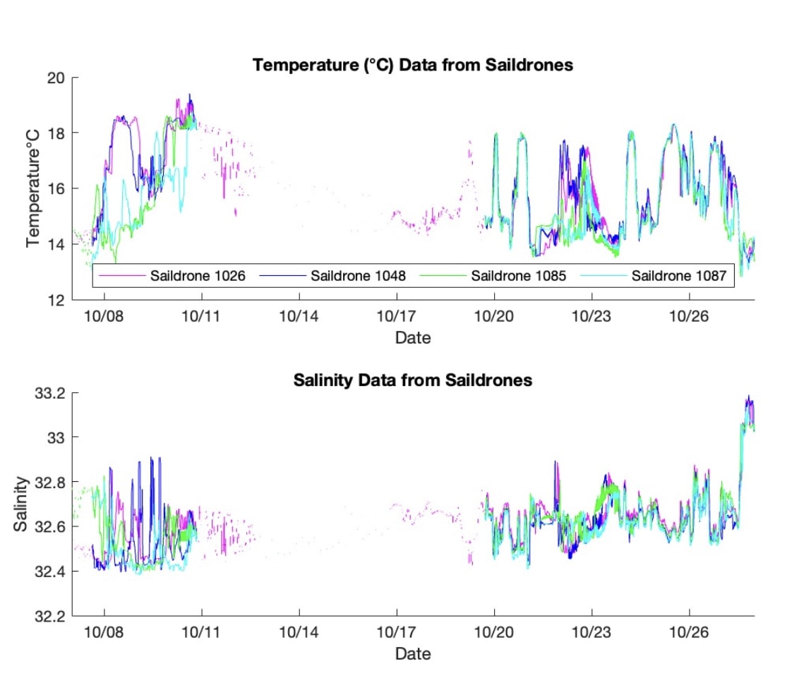
S-MODE L2 Temperature and Salinity from Saildrones Version 1 recent views
National Aeronautics and Space Administration —
This dataset contains Saildrone in-situ measurements taken during the Sub-Mesoscale Ocean Dynamics Experiment (S-MODE) conducted approximately 300 km offshore of San... -
Federal
ECCO Atmosphere Surface Temperature, Humidity, Wind, and Pressure - Daily Mean 0.5 Degree (Version 4 Release 4) recent views
National Aeronautics and Space Administration —
This dataset contains daily-averaged atmosphere surface temperature, humidity, wind, and pressure interpolated to a regular 0.5-degree grid from the ECCO Version 4... -
Federal
Remote Sensing Systems Radiometer Rain Collocations with JPL RapidScat L2B Swath Grid recent views
National Aeronautics and Space Administration —
This dataset contains the multi-sourced microwave radiometer wind speed, rain and cloud liquid water data collocated to RapidScat Level 2B wind vector cell (WVC)... -
Federal
Aquarius Celestial Sky Microwave Emission Map Ancillary Dataset V1.0 recent views
National Aeronautics and Space Administration —
This datasets contains three maps of L-band (wavelength = 21 cm) brightness temperature of the celestial sky ("Galaxy") used in the processing of the NASA Aquarius... -
Federal
Saildrone field campaign surface and ADCP measurements for the Atlantic Tradewind Ocean-Atmosphere Mesoscale Interaction Campaign (ATOMIC) project recent views
National Aeronautics and Space Administration —
Saildrone is a wind and solar powered unmanned surface vehicle (USV) capable of long distance deployments lasting up to 12 months and providing high quality, near... -
Federal
S-MODE Saildrone Level 1 Observations recent views
National Aeronautics and Space Administration —
This dataset contains a suite of Saildrone in-situ measurements (including but not limited to temperature, salinity, currents, biochemistry, and meteorology) taken... -
Federal
ECCO Ocean and Sea-Ice Surface Freshwater Fluxes - Daily Mean 0.5 Degree (Version 4 Release 4) recent views
National Aeronautics and Space Administration —
This dataset contains daily-averaged ocean and sea-ice surface freshwater fluxes interpolated to a regular 0.5-degree grid from the ECCO Version 4 revision 4 (V4r4)... -
Federal
SPURS-2 S/V Lady Amber underway Thermosalinograph and Sea Snake data for the E. Tropical Pacific field campaign recent views
National Aeronautics and Space Administration —
The SPURS (Salinity Processes in the Upper Ocean Regional Study) project is a NASA-funded oceanographic process study and associated field program that aim to... -
Federal
SASSIE Arctic Field Campaign Wave Glider Data Fall 2022 Version 1 recent views
National Aeronautics and Space Administration —
The Salinity and Stratification at the Sea Ice Edge (SASSIE) project is a NASA experiment that aims to understand how salinity anomalies in the upper ocean generated... -
Federal
SPURS-2 research vessel along track SEA-POL rain radar imaging data for E. Tropical Pacific R/V Revelle-2 cruise recent views
National Aeronautics and Space Administration —
The SPURS (Salinity Processes in the Upper Ocean Regional Study) project is NASA-funded oceanographic process study and associated field program that aim to elucidate... -
Federal
SASSIE Arctic Field Campaign Shipboard Meteorology Data Fall 2022 recent views
National Aeronautics and Space Administration —
The Salinity and Stratification at the Sea Ice Edge (SASSIE) project is a NASA experiment that aims to understand how salinity anomalies in the upper ocean generated... -
Federal
S-MODE DopplerScatt Level 2 Ocean Winds and Currents Version 1 recent views
National Aeronautics and Space Administration —
This dataset contains concurrent airborne DopplerScatt radar retrievals of surface vector winds and ocean currents from the Sub-Mesoscale Ocean Dynamics Experiment... -
Federal
SASSIE Arctic Field Campaign L1 SWIFT Data Fall 2022 recent views
National Aeronautics and Space Administration —
The Salinity and Stratification at the Sea Ice Edge (SASSIE) project is a NASA experiment that aims to understand how salinity anomalies in the upper ocean generated... -
Federal
SASSIE Arctic Field Campaign L1 Wave Glider Data Fall 2022 recent views
National Aeronautics and Space Administration —
The Salinity and Stratification at the Sea Ice Edge (SASSIE) project is a NASA experiment that aims to understand how salinity anomalies in the upper ocean generated... -
Federal
ECCO Ocean and Sea-Ice Surface Freshwater Fluxes - Monthly Mean 0.5 Degree (Version 4 Release 4) recent views
National Aeronautics and Space Administration —
This dataset contains monthly-averaged ocean and sea-ice surface freshwater fluxes interpolated to a regular 0.5-degree grid from the ECCO Version 4 revision 4 (V4r4)... -
Federal
ECCO Atmosphere Surface Temperature, Humidity, Wind, and Pressure - Monthly Mean llc90 Grid (Version 4 Release 4) recent views
National Aeronautics and Space Administration —
This dataset provides monthly-averaged atmosphere surface temperature, humidity, winds, and pressure on the native Lat-Lon-Cap 90 (LLC90) model grid from the ECCO...

Official websites use .gov
A
.gov website belongs to an official government
organization in the United States.
Secure .gov websites use HTTPS
A
lock (
) or https:// means you’ve safely connected to
the .gov website. Share sensitive information only on official,
secure websites.