
-
Federal
Klamath Basin Restoration Agreement Off-Project Water Program Evapotranspiration Map for September 2004
Department of the Interior —
Hydrological Information Products for the Off-Project Water Program of the Klamath Basin Restoration Agreement U.S. Geological Survey Open-File Report 2012-1199 U.S.... -
Federal
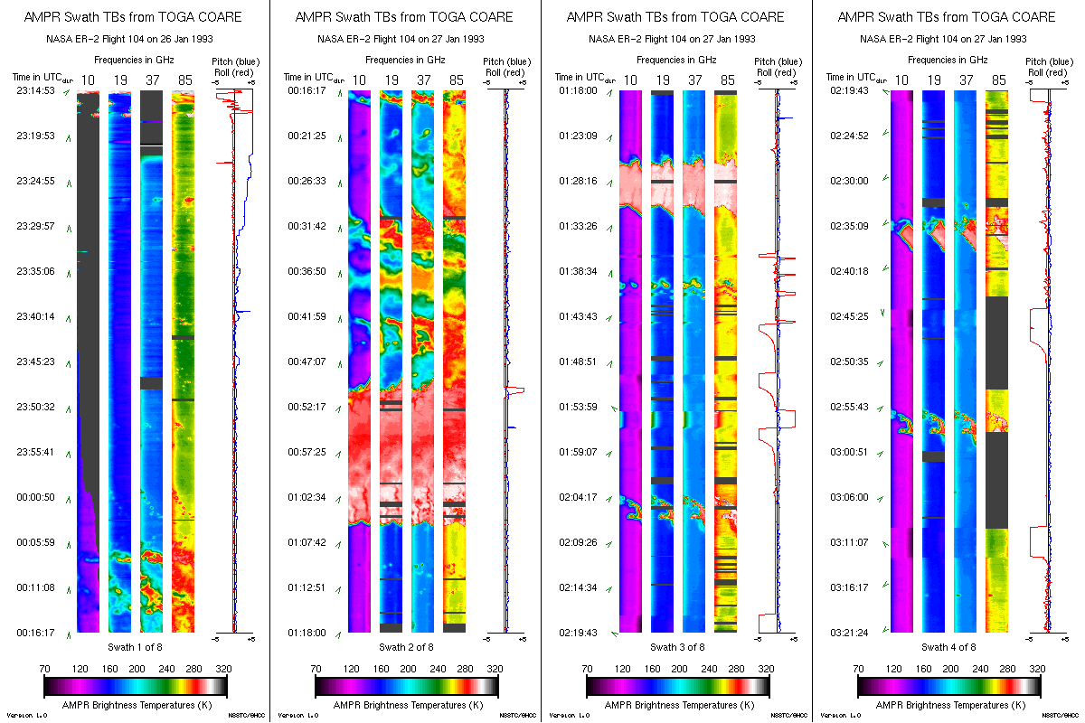
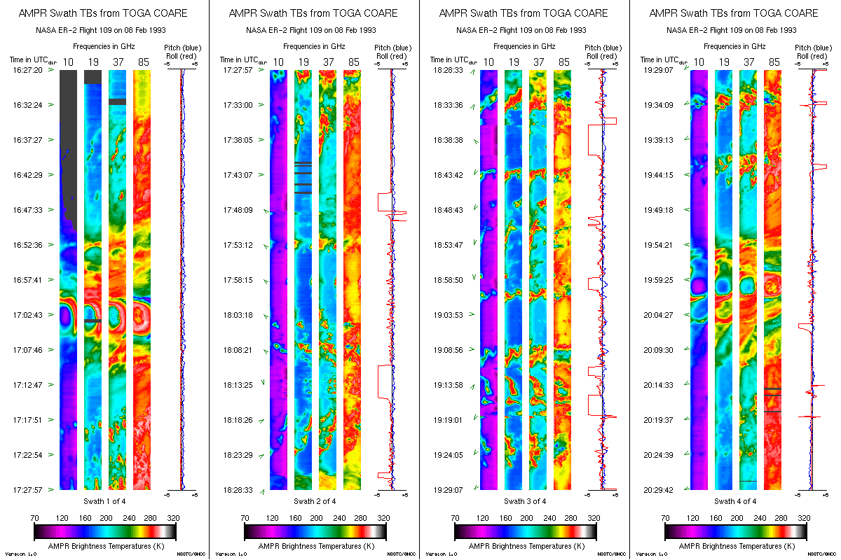
AMPR BRIGHTNESS TEMPERATURE (TB) TOGA COARE V2
National Aeronautics and Space Administration —
The Advanced Microwave Precipitation Radiometer (AMPR) data set was part of the atmospheric measurements collected during the intensive observation period of the... -
Federal
Estimated crop irrigation water use withdrawals in Willcox Groundwater Basin, Arizona for 2023
Department of the Interior —
Observations of irrigated agricultural land within the Willcox Groundwater Basin in Arizona. Crops were verified in situ three times in 2023, first on May 3rd, then... -
Federal
R-Factor for the Island of Lanai
National Oceanic and Atmospheric Administration, Department of Commerce —
The rainfall-runoff erosivity factor (R-Factor) quantifies the effects of raindrop impacts and reflects the amount and rate of runoff associated with the rain. The... -
Federal
R-Factor for the Island of Puerto Rico
National Oceanic and Atmospheric Administration, Department of Commerce —
The rainfall-runoff erosivity factor (R-Factor) quantifies the effects of raindrop impacts and reflects the amount and rate of runoff associated with the rain. The... -
Federal
Shannon diversity index data based on Community Level Physiological Profiling (CLPP) of soil samples from 120 point locations within limestone cedar glades at Stones River National Battlefield near Murfreesboro, Tennessee
Department of the Interior —
This dataset contains data collected within limestone cedar glades at Stones River National Battlefield (STRI) near Murfreesboro, Tennessee. This dataset contains... -
Federal
Gridded uniform hazard peak ground acceleration data and 84th-percentile peak ground acceleration data used to calculate the Maximum Considered Earthquake Geometric Mean (MCEG) peak ground acceleration (PGA) values of the 2020 NEHRP Recommended Seismic Provisions and 2022 ASCE/SEI 7 Standard for Hawaii.
Department of the Interior —
The Maximum Considered Earthquake Geometric Mean (MCEG) peak ground acceleration (PGA) values of the 2020 NEHRP Recommended Seismic Provisions and 2022 ASCE/SEI 7... -
Federal
Salinity_na_tropical: Modeling the effects of large-scale interior headland restoration on tidal hydrodynamics and salinity transport in an open coast, marine-dominant estuary: model input and results
Department of the Interior —
Using version 20.1_19 of the Discontinuous-Galerkin Shallow Water Equations Model (DG-SWEM) (Kubatko and others, 2006), astronomic tides and salinity transport were... -
Federal
ESA CCI Ocean Colour Product (CCI ALL-v4.2-MONTHLY), 0.04166666°, 1997-2020
National Oceanic and Atmospheric Administration, Department of Commerce —
Data products generated by the Ocean Colour component of the European Space Agency Climate Change Initiative project. These files are monthly composites of merged... -
Federal
Aqua MODIS Level-2 Regional 4µm Nighttime Sea Surface Temperature (SST4) Data, version R2019.0 NGDA
National Aeronautics and Space Administration —
MODIS (or Moderate-Resolution Imaging Spectroradiometer) is a key instrument aboard the Terra (EOS AM) and Aqua (EOS PM) satellites. Terra's orbit around the Earth is... -
Federal
CERES MODIS Cloud Retrievals in ISCCP-D2like Format Daytime Aqua FM4 Edition3A NGDA
National Aeronautics and Space Administration —
CER_ISCCP-D2like-Day_Aqua-FM4-MODIS_Edition3A is the Clouds and the Earth's Radiant Energy System (CERES) Moderate Resolution Imaging Spectroradiometer (MODIS) Cloud... -
Federal
Alaska Harbor Seal Glacial Surveys
National Oceanic and Atmospheric Administration, Department of Commerce —
Floating glacial ice serves as a haul-out substrate for a significant number (10-15%) of Alaskan harbor seals, and thus surveying tidewater glacial fjords is an... -
Federal
TOVS GLA DAILY GRIDS from NOAA-12 V01 (TOVSADND) at GES DISC
National Aeronautics and Space Administration —
This dataset (TOVSADND) contains the TIROS Operational Vertical Sounder (TOVS) level 3 geophysical parameters derived using data from NOAA-12 and the physical... -
Federal
MetOp-C ASCAT Level 2 25.0km Ocean Surface Wind Vectors in Full Orbit Swath
National Aeronautics and Space Administration —
This dataset contains operational near-real-time Level 2 ocean surface wind vector retrievals from the Advanced Scatterometer (ASCAT) on MetOp-C at 25 km sampling... -
Federal
Global climatology of 13 underwater acoustic parameters derived from WOA-2023 (NCEI Accession 0290599)
National Oceanic and Atmospheric Administration, Department of Commerce —
Acoustics is most effective in undersea detection, localization, and communication. However, there is no global climatology of underwater acoustic parameters. A... -
Federal
4. Estimation of Vertical Groundwater/Surface-water Exchange Using the tempest1d Model: Data from the Mainstem Quillayute River, Summer 2021
Department of the Interior —
This dataset includes all files used to model groundwater-surface water exchange at mainstem locations on the lower Quillayute River, WA in summer 2021. Sediment... -
Federal
SRTM30_PLUS Estimated Topography, 30 seconds, Global, v11, Lon+/-180
National Oceanic and Atmospheric Administration, Department of Commerce —
One GMT file, topo30.grd, with the entire global topography. The grid resolution is 30 seconds which is roughly 0.55km at the equator. The data are pixel registered.... -
Federal
Climate Forecast System Reanalysis (CFSR), for 1979 to 2011
National Oceanic and Atmospheric Administration, Department of Commerce —
The NCEP Climate Forecast System Reanalysis (CFSR) was initially completed for the 31-year period from 1979 to 2009, in January 2010. The CFSR was designed and... -
Federal
LANDFIRE Remap Forest Canopy Base Height (CBH) CONUS
Department of the Interior —
LANDFIRE's (LF) Remap Canopy Base Height (CBH) supplies information used in fire behavior models to determine the critical point at which a surface fire will... -
Federal
NOAA Climate Data Record (CDR) of MSU and AMSU-A Mean Layer Temperatures, UAH Version 6.0
National Oceanic and Atmospheric Administration, Department of Commerce —
This dataset includes monthly gridded temperature anomalies on a global 2.5 x 2.5 degree grid derived from Microwave Sounding Unit (MSU) and Advanced Microwave...

Official websites use .gov
A
.gov website belongs to an official government
organization in the United States.
Secure .gov websites use HTTPS
A
lock (
) or https:// means you’ve safely connected to
the .gov website. Share sensitive information only on official,
secure websites.