
-
Federal
OSCAR 1 degree ocean surface currents recent views
National Aeronautics and Space Administration —
OSCAR (Ocean Surface Current Analysis Real-time) contains near-surface ocean current estimates, derived using quasi-linear and steady flow momentum equations. The... -
Federal
S-MODE MASS Level 1 Visible Imagery Version 1 recent views
National Aeronautics and Space Administration —
This dataset contains airborne visible imagery from the Sub-Mesoscale Ocean Dynamics Experiment (S-MODE) during a pilot campaign conducted approximately 300 km... -
Federal
GHRSST Level 2P Western Atlantic Regional Skin Sea Surface Temperature from the Geostationary Operational Environmental Satellites (GOES) Imager on the GOES-13 satellite (GDS version 2) recent views
National Aeronautics and Space Administration —
The Geostationary Operational Environmental Satellites (GOES) operated by the United States National Oceanic and Atmospheric Administration (NOAA) support weather... -
Federal
ATom: GEOS-5 Derived Meteorological Conditions and Tagged Tracers Along Flight Tracks recent views
National Aeronautics and Space Administration —
This dataset provides modeled meteorological conditions and tagged-CO tracer concentrations along ATom flight paths derived from the Goddard Earth Observing System... -
Federal
SNPP CrIS-VIIRS 750-m Matchup Indexes V1 (SNPP_CrIS_VIIRS750m_IND) at GES_DISC recent views
National Aeronautics and Space Administration —
This dataset includes SNPP VIIRS-CrIS collocation index product, within the framework of the Multidecadal Satellite Record of Water Vapor, Temperature, and Clouds... -
Federal
Aquarius Official Release Level 3 Sea Surface Density Standard Mapped Image Descending Daily Data V5.0 recent views
National Aeronautics and Space Administration —
Aquarius Level 3 sea surface density standard mapped image data contains gridded 1 degree spatial resolution density data averaged over daily, 7 day, monthly, and... -
Federal
H13088: NOS Hydrographic Survey , 2017-11-06 recent views
National Oceanic and Atmospheric Administration, Department of Commerce —
The National Oceanic and Atmospheric Administration (NOAA) has the statutory mandate to collect hydrographic data in support of nautical chart compilation for safe... -
Federal
W00119: NOS Hydrographic Survey , Outside Source Data - 2003, 2003-10-07 recent views
National Oceanic and Atmospheric Administration, Department of Commerce —
The National Oceanic and Atmospheric Administration (NOAA) has the statutory mandate to collect hydrographic data in support of nautical chart compilation for safe... -
Federal
CYGNSS Level 1 Climate Data Record Version 1.2 recent views
National Aeronautics and Space Administration —
This Level 1 (L1) dataset contains the Version 1.2 Climate Data Record (CDR) of the geo-located Delay Doppler Maps (DDMs) calibrated into Power Received (Watts) and... -
Federal
Aboveground Biomass from SAR, Great Slave Lake Region, NWT, 2019 recent views
National Aeronautics and Space Administration —
This dataset holds aboveground biomass (ABG) estimates for areas in the Great Slave Lake Region in the Northwest Territories of Canada for 2019. ABG was estimated... -
Federal
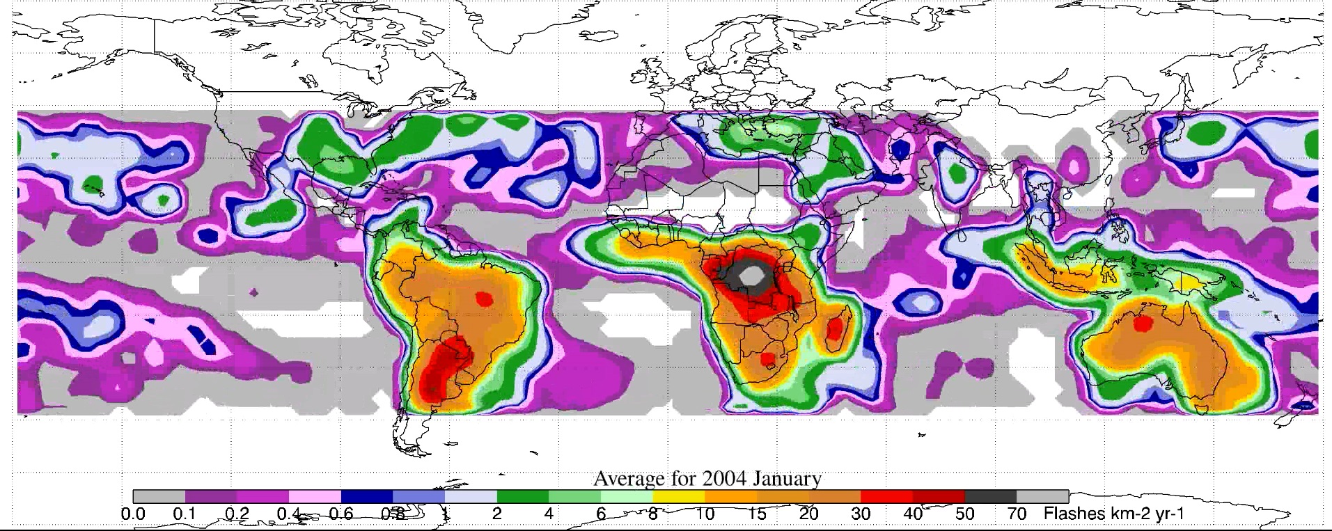
LIS/OTD 2.5 Degree Low Resolution Monthly Climatology Time Series (LRMTS) V2.3.2015 recent views
National Aeronautics and Space Administration —
The LIS/OTD 2.5 Degree Low Resolution Monthly Climatology Time Series (LRMTS) contains a variety of gridded climatologies of total lightning flash rates obtained from... -
Federal
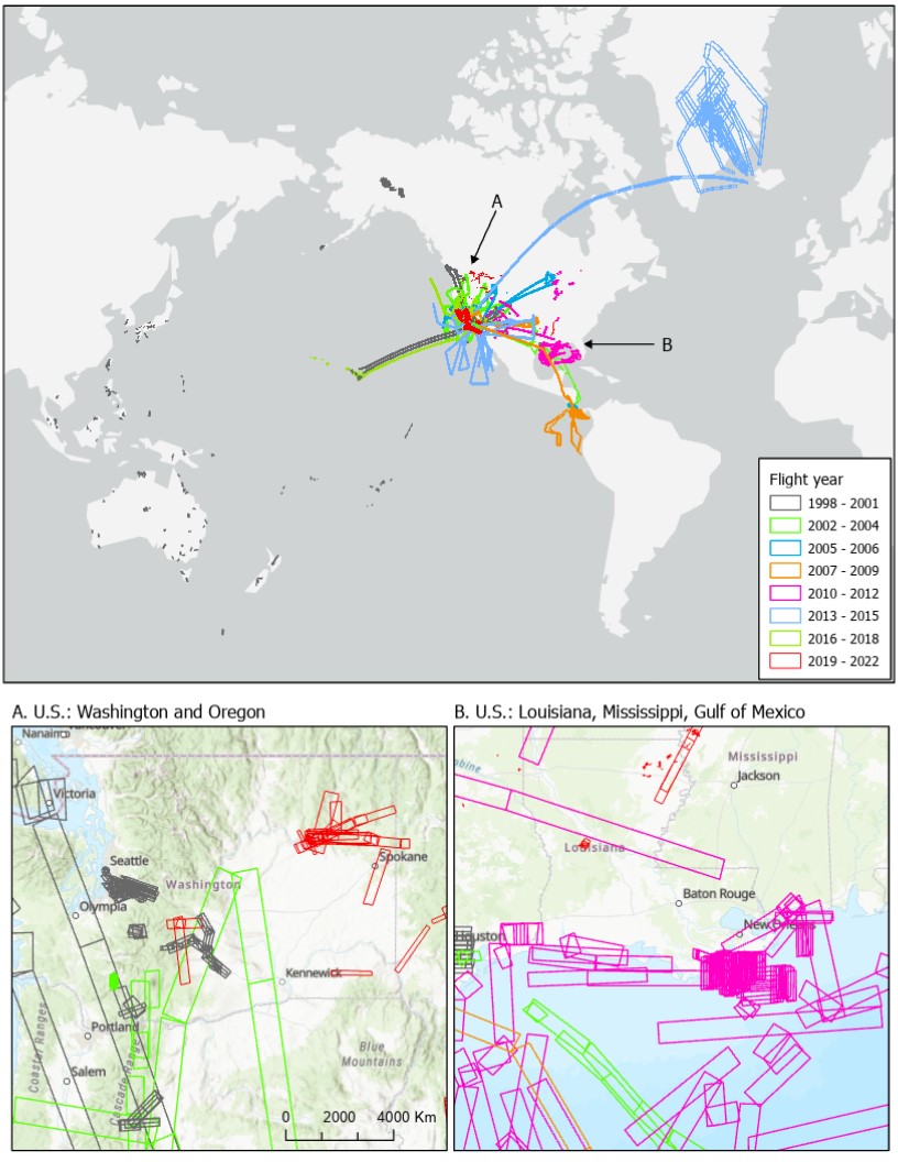
MASTER: Flight Line Geospatial Polygons and Contextual Data recent views
National Aeronautics and Space Administration —
This dataset provides resources for identifying flight lines of interest for the MODIS/ASTER Airborne Simulator (MASTER) instrument based on spatial and temporal... -
Federal
Aquarius Official Release Level 3 Rain-flagged Sea Surface Salinity Standard Mapped Image Seasonal Data V5.0 recent views
National Aeronautics and Space Administration —
Aquarius Level 3 sea surface salinity (SSS) rain-flagged standard mapped image data contains gridded 1 degree spatial resolution SSS averaged over daily, 7 day,... -
Federal
VIIRS/NPP Vegetation Indices 16-Day L3 Global 1km SIN Grid V001 recent views
National Aeronautics and Space Administration —
The NASA/NOAA Suomi National Polar-orbiting Partnership (Suomi NPP) Visible Infrared Imaging Radiometer Suite (VIIRS) Vegetation Indices (VNP13A2) Version 1 data... -
Federal
Ecomapper data for the SPURS-1 N. Atlantic field campaign recent views
National Aeronautics and Space Administration —
The SPURS (Salinity Processes in the Upper Ocean Regional Study) project is an oceanographic process study and associated field program that aim to elucidate key... -
Federal
China Dimensions Data Collection: GuoBiao (GB) Codes for the Administrative Divisions of the Peoples Republic of China recent views
National Aeronautics and Space Administration —
The GuoBiao (GB) Codes for the Administrative Divisions of the People's Republic of China consists of geographic codes for the administrative divisions of China. The... -
Federal
ATom: Data Stream for Modeling the Reactivity of ATom Air Parcels, 2016-2018 recent views
National Aeronautics and Space Administration —
This dataset provides Modeling Data Stream (MDS) and Reactivity Data Stream (RDS) products for each of the four ATom campaigns conducted from 2016 to 2018. MDS files... -
Federal
Carbon Stocks of Individual Trees in African Drylands: Allometry and Output Data recent views
National Aeronautics and Space Administration —
This dataset provides allometrically-estimated carbon stocks of 9,947,310,221 tree crowns derived from 50-cm resolution satellite images within the 0 to 1000 mm/year... -
Federal
Perdido Host - Alaminos Canyon 857 recent views
National Oceanic and Atmospheric Administration, Department of Commerce —
GCOOS 52North Sensor Observation Service This station provides the following variables: Air pressure, Air temperature, Dew point temperature, Direction of sea water... -
Federal
Northwest Pacific Pre-SWOT Level-4 Hourly MITgcm LLC4320 Native Grid 2km Oceanographic Dataset Version 1.0 recent views
National Aeronautics and Space Administration —
This dataset provides a regional multivariate oceanographic state estimate from a global ocean numerical simulation with a focus on the Northwest Pacific Ocean...

Official websites use .gov
A
.gov website belongs to an official government
organization in the United States.
Secure .gov websites use HTTPS
A
lock (
) or https:// means you’ve safely connected to
the .gov website. Share sensitive information only on official,
secure websites.
.jpg)