
-
Federal
TIGER/Line Shapefile, 2023, State, Nebraska, Primary and Secondary Roads recent views
U.S. Census Bureau, Department of Commerce —
The TIGER/Line shapefiles and related database files (.dbf) are an extract of selected geographic and cartographic information from the U.S. Census Bureau's Master... -
Federal
United States Stage IV Quantitative Precipitation Archive recent views
Department of the Interior —
This dataset offers hourly estimates of radar indicated rain gage corrected precipitation at a roughly 4km spatial resolution. Mosaicked into a national product at... -
Federal
Near-Real Time Surface Ocean Velocity, Hawaii, 6 km Resolution recent views
National Oceanic and Atmospheric Administration, Department of Commerce —
Surface ocean velocities estimated from HF-Radar (HFR) are representative of the upper 0.3 - 2.5 meters of the ocean. The main objective of near-real time processing... -
Federal
Severe Injury Report (SIR) Data recent views
Department of Labor —
Through CFR 1904.39, OSHA also has the primary responsibility of cleaning, compiling and publishing Severe Injury Report (SIR) data. These data include employer... -
University
Bark Beetle-caused Tree Mortality for the Stanley, Idaho Study Area recent views
University of Idaho —
The downloadable ZIP file contains a georeferenced TIF. This raster layer is a supervised maximum likelihood classification of bark beetle-caused tree mortality based... -
Federal
Data and Model Archive Summaries to Support Use of Continuous Water-Quality Time-Series Data to Compute Total Phosphorus Concentrations and Loads for the Missouri River at St. Joseph and Hermann, Missouri, 2007–22 recent views
Department of the Interior —
This data release contains the R source code, inputs, and selected outputs associated with the turbidity-based regression models used to estimate total phosphorus... -
Federal
BLM CO Lands Wilderness Characteristics recent views
Department of the Interior —
BLM Lands Inventoried for Wilderness Characteristics is consistent with Section 201 of the Federal Land Policy and Management Act (FLPMA), which requires the... -
City
Jefferson County KY Voting Precincts 2020 recent views
Louisville Metro Government —
This dataset contains polygons and attributes which represent the 623 voting precincts in Jefferson County, Kentucky. It includes the precinct name or number... -
Federal
TIGER/Line Shapefile, 2021, State, Oregon, Unified School Districts recent views
U.S. Census Bureau, Department of Commerce —
The TIGER/Line shapefiles and related database files (.dbf) are an extract of selected geographic and cartographic information from the U.S. Census Bureau's Master... -
Federal
National Land Cover Database (NLCD) Impervious Products NGDA recent views
Department of the Interior —
The U.S. Geological Survey (USGS), in association with the Multi-Resolution Land Characteristics (MRLC) Consortium, produces the National Land Cover Database (NLCD)... -
Federal
Public-supply water service areas within the conterminous United States, 2017 recent views
Department of the Interior —
This data release describes water service areas (WSA) for community water systems (CWS) within the conterminous United States, representing areas of active service... -
Federal
Distance to Nearest Coastline: 0.01-Degree Grid: Ocean recent views
National Oceanic and Atmospheric Administration, Department of Commerce —
A global data set of ocean distances from the nearest coastline. NASA's Ocean Biology Processing Group (OBPG) generated this data set using the Generic Mapping Tools... -
Federal
1-Minute Page 1 Surface Weather Observations from the Automated Surface Observing Systems (ASOS) Network recent views
National Oceanic and Atmospheric Administration, Department of Commerce —
This dataset includes one-minute observations for visibility extinction coefficient, 2-minute average and 5-second peak wind speed and direction, and runway visual... -
Federal
2020 Cartographic Boundary File (KML), Current County Subdivision for Oklahoma, 1:500,000 recent views
U.S. Census Bureau, Department of Commerce —
The 2020 cartographic boundary KMLs are simplified representations of selected geographic areas from the U.S. Census Bureau's Master Address File / Topologically... -
Federal
Superfund Site Information recent views
U.S. Environmental Protection Agency —
This asset includes a number of individual data sets related to site-specific information for Superfund, which is governed under the Comprehensive Environmental... -
Federal
Concentrated Animal Feeding Operations (CAFOs) per County Downloadable Package, US, 2013, US EPA recent views
U.S. Environmental Protection Agency —
This downloadable data package contains the following map layer: An ESRI polygon layer which depicts the boundaries of each US county. It has been joined with a US... -
Federal
Sudden Ionospheric Disturbances (SID) recent views
National Oceanic and Atmospheric Administration, Department of Commerce —
Sudden ionospheric disturbances (SID) are caused by solar flare enhanced X-rays in the 1 to 10 angstrom range. Solar flares can produce large increases of ionization... -
Federal
TIGER/Line Shapefile, 2021, State, Florida, Block Groups recent views
U.S. Census Bureau, Department of Commerce —
The TIGER/Line shapefiles and related database files (.dbf) are an extract of selected geographic and cartographic information from the U.S. Census Bureau's Master... -
Federal
MERRA-2 tavg1_2d_slv_Nx: 2d,1-Hourly,Time-Averaged,Single-Level,Assimilation,Single-Level Diagnostics 0.625 x 0.5 degree V5.12.4 (M2T1NXSLV) at GES DISC recent views
National Aeronautics and Space Administration —
M2T1NXSLV (or tavg1_2d_slv_Nx) is an hourly time-averaged 2-dimensional data collection in Modern-Era Retrospective analysis for Research and Applications version 2... -
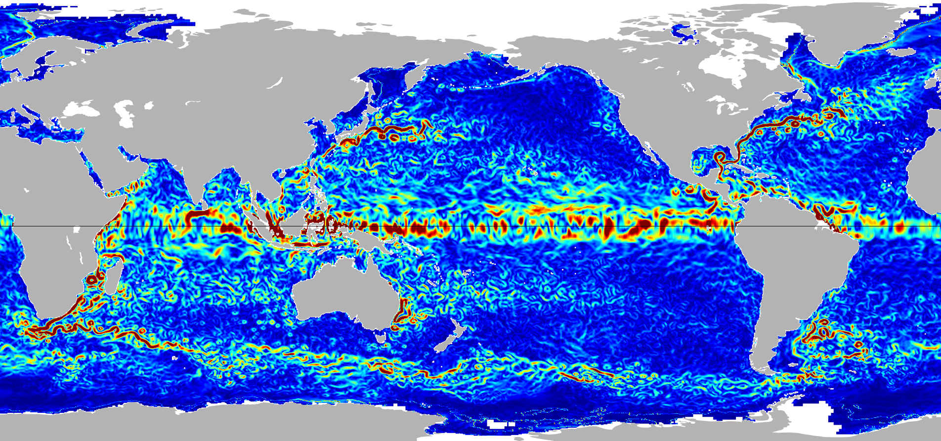
Federal
Ocean Surface Current Analyses Real-time (OSCAR) Surface Currents - Near Real Time 0.25 Degree (Version 2.0) recent views
National Aeronautics and Space Administration —
Ocean Surface Current Analyses Real-time (OSCAR) is a global surface current database and NASA funded research project. OSCAR ocean mixed layer velocities are...

Official websites use .gov
A
.gov website belongs to an official government
organization in the United States.
Secure .gov websites use HTTPS
A
lock (
) or https:// means you’ve safely connected to
the .gov website. Share sensitive information only on official,
secure websites.