
-
Federal
Global Fertilizer and Manure, Version 1: Nitrogen in Manure Production
National Aeronautics and Space Administration —
The Nitrogen in Manure Production data set of the Global Fertilizer and Manure, Version 1 Data Collection represents the amount of nitrogen manure produced and... -
Federal
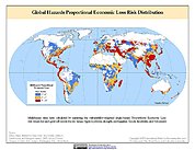
Global Earthquake Proportional Economic Loss Risk Deciles
National Aeronautics and Space Administration —
The Global Earthquake Proportional Economic Loss Risk Deciles is a 2.5 minute grid of earthquake hazard economic loss as proportions of Gross Domestic Product (GDP)... -
Federal
Gridded Population of the World, Version 4 (GPWv4): Land and Water Area, Revision 11
National Aeronautics and Space Administration —
The Gridded Population of the World, Version 4 (GPWv4): Land and Water Area, Revision 11 consists of two rasters that measure surface areas of land and water in... -
Federal
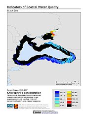
Indicators of Coastal Water Quality: Change in Chlorophyll-a Concentration 1998-2007
National Aeronautics and Space Administration —
The Change in Chlorophyll-a Concentrations 1998-2007 component of the Indicators of Coastal Water Quality Collection represents a tabular time series of the... -
Federal
Global Flood Proportional Economic Loss Risk Deciles
National Aeronautics and Space Administration —
The Global Flood Proportional Economic Loss Risk Deciles is a 2.5 minute grid of flood hazard economic loss as proportions of Gross Domestic Product (GDP) per... -
Federal
Global Multihazard Mortality Risks and Distribution
National Aeronautics and Space Administration —
The Global Multihazard Mortality Risks and Distribution is a 2.5 minute grid identifying and characterizing the nature of multihazard risk at the global scale. For... -
Federal
National Aggregates of Geospatial Data Collection: Population, Landscape, And Climate Estimates (PLACE)
National Aeronautics and Space Administration —
The National Aggregates of Geospatial Data Collection: Population, Landscape, And Climate Estimates (PLACE) data set contains estimates of national-level aggregations... -
Federal
Compendium of Environmental Sustainability Indicator Collections: Complete Collection, Version 1.1
National Aeronautics and Space Administration —
The Compendium of Environmental Sustainability Indicator Collections, Version 1.1 contains 426 indicators for 239 countries from five major environmental... -
Federal
Archive of Census Related Products (ACRP): 1990 SAS Transport Files
National Aeronautics and Space Administration —
The 1990 SAS Transport Files portion of the Archive of Census Related Products (ACRP) contains housing and population data from the U.S. Census Bureau's 1990 Summary... -
Federal
Last of the Wild Project, Version 2, 2005 (LWP-2): Global Human Influence Index (HII) Dataset (IGHP)
National Aeronautics and Space Administration —
The Global Human Influence Index Dataset of the Last of the Wild Project, Version 2, 2005 (LWP-2) is a global dataset of 1-kilometer grid cells, created from nine... -
Federal
Last of the Wild Project, Version 1, 2002 (LWP-1): Global Human Footprint Dataset (IGHP)
National Aeronautics and Space Administration —
The Global Human Footprint Dataset of the Last of the Wild Project, Version 1, 2002 (LWP-1) is the Human Influence Index (HII) normalized by biome and realm. The HII... -
Federal
West Africa Coastal Vulnerability Mapping: Subset of OpenStreetMap (OSM) Roads
National Aeronautics and Space Administration —
The West Africa Coastal Vulnerability Mapping: Subset of OpenStreetMap (OSM) Roads data set includes roads within 200 kilometers of the coast and was extracted from... -
Federal
Low Elevation Coastal Zone (LECZ) Urban-Rural Population and Land Area Estimates, Version 2
National Aeronautics and Space Administration —
The Low Elevation Coastal Zone (LECZ) Urban-Rural Population and Land Area Estimates, Version 2 data set consists of country-level estimates of urban population,... -
Federal
Twentieth Century Crop Statistics, 1900-2017
National Aeronautics and Space Administration —
The Twentieth Century Crop Statistics, 1900-2017 data set consists of national or subnational maize and wheat production, yield, and harvested area statistics for all... -
Federal
Last of the Wild Project, Version 1, 2002 (LWP-1): Top One Percent Wild Areas Dataset (Geographic)
National Aeronautics and Space Administration —
The Top One Percent Wild Areas Dataset of the Last of the Wild Project, Version 1, 2002 (LWP-1) is derived from the LWP-1 Human Footprint Dataset. The gridded data... -
Federal
ATSDR Hazardous Waste Site Polygon Data, Version 2
National Aeronautics and Space Administration —
The Agency for Toxic Substances and Disease Registry (ATSDR) Hazardous Waste Site Polygon Data, Version 2 consists of 2,080 polygons for selected hazardous waste... -
Federal
Global Multihazard Proportional Economic Loss Risk Deciles
National Aeronautics and Space Administration —
The Global Multihazard Proportional Economic Loss Risks is a 2.5 minute grid of a multihazard-based economic loss risk as a proportion of the economic productivity of... -
Federal
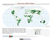
Global Agricultural Lands: Pastures, 2000
National Aeronautics and Space Administration —
The Global Pastures data set represents the proportion of land areas used as pasture land (land used to support grazing animals) in the year 2000. Satellite data from... -
Federal
Daily and Annual NO2 Concentrations for the Contiguous United States, 1-km Grids, v1 (2000 - 2016)
National Aeronautics and Space Administration —
The Daily and Annual NO2 Concentrations for the Contiguous United States, 1-km Grids, v1 (2000-2016) data set contains daily predictions of Nitrogen Dioxide (NO2)... -
Federal
Global Landslide Proportional Economic Loss Risk Deciles
National Aeronautics and Space Administration —
The Global Landslide Proportional Economic Loss Risk Deciles is a 2.5 minute grid of landslide hazard economic loss as proportions of Gross Domestic Product (GDP) per...

Official websites use .gov
A
.gov website belongs to an official government
organization in the United States.
Secure .gov websites use HTTPS
A
lock (
) or https:// means you’ve safely connected to
the .gov website. Share sensitive information only on official,
secure websites.