
-
Federal
UARS Improved Stratospheric and Mesospheric Sounder (ISAMS) Level 3AL V010 (UARIS3AL) at GES DISC
National Aeronautics and Space Administration —
The Improved Stratospheric and Mesospheric Sounder (ISAMS) Level 3AL data product consists of daily, 4 degree increment latitude-ordered vertical profiles of... -
Federal
UARS Solar Ultraviolet Spectral Irradiance Monitor (SUSIM) Level 3BS V022 (UARSU3BS) at GES DISC
National Aeronautics and Space Administration —
The Solar Ultraviolet Spectral Irradiance Monitor (SUSIM) Level 3BS data product consists of daily, 1 nm resolution, solar spectral irradiances and selected solar... -
Federal
Crop response and changes in soil properties as affected by soil erosion, topsoil replacement, and application of anaerobically digested dairy manure solids in a Mollisol landform
Department of Agriculture —
These data provide field measurements of plant and soil at a geographical site as affected by (a) tillage and water erosion (b) replacement of translocated topsoil... -
Federal
UARS Halogen Occultation Experiment (HALOE) Level 2 V019 (UARHA2FN) at GES DISC
National Aeronautics and Space Administration —
The Halogen Occultation Experiment (HALOE) Level 2 data product consists of daily vertical profiles of temperature, aerosol extinciton and pressure, as well as... -
Federal
UARS High Resolution Doppler Imager (HRDI) Level 3AL V011 (UARHR3AL) at GES DISC
National Aeronautics and Space Administration —
The High Resolution Doppler Imager (HRDI) Level 3AL data product consists of daily, 4 degree increment latitude-ordered vertical profiles of meridional and zonal wind... -
Federal
2010 NOAA/USGS Lidar: French Frigate Shoals, NWHI
National Oceanic and Atmospheric Administration, Department of Commerce —
The U.S. Geological Survey (USGS) contracted with Hawaii-based Aerial Surveying, Inc. to collect lidar-derived elevation data over the low-lying areas within the... -
Federal
AIR TEMPERATURE, Surface pressure, and others collected from FIXED STATIONS OF CANADA in Canada from 1768-09-11 to 1884-02-29 (NCEI Accession 0304217)
National Oceanic and Atmospheric Administration, Department of Commerce —
Historical weather journals from across Canada, spanning 1768 - 1884, have been transcribed from handwritten records into machine readable formats. The NORTHERN... -
Federal
UARS High Resolution Doppler Imager (HRDI) Level 3AT V011 (UARHR3AT) at GES DISC
National Aeronautics and Space Administration —
The High Resolution Doppler Imager (HRDI) Level 3AT data product consists of daily, 65.536 second interval time-ordered vertical profiles of meridional and zonal wind... -
Federal
UARS Correlative UKMO Daily Gridded Stratospheric Assimilated Data V001 (UARZCUKM) at GES DISC
National Aeronautics and Space Administration —
The UARS Correlative assimilation data from the U.K. Meteorological Office (UKMO) consists of daily model runs at 12:00 GMT as a means of providing an independent... -
Federal
OMI/Aura Multi-wavelength Aerosol Optical Depth and Single Scattering Albedo Daily L2 Global Gridded 0.25 degree x 0.25 degree V3 (OMAEROG) at GES DISC
National Aeronautics and Space Administration —
This Level-2G daily global gridded product OMAEROG is based on the pixel level OMI Level-2 Aerosol product OMAERO, based on the multi-wavelength algorithm that uses... -
Federal
UARS Wind Imaging Interferometer (WINDII) Level 3AT V011 (UARWI3AT) at GES DISC
National Aeronautics and Space Administration —
The Wind Imaging Interferometer (WINDII) Level 3AT data product consists of daily, 65.536 second interval time-ordered vertical profiles of meridional and zonal wind... -
Federal
UARS Solar-Stellar Irradiance Comparison Experiment (SOLSTICE) Level 3BS V018 (UARSO3BS) at GES DISC
National Aeronautics and Space Administration —
The Solar-Stellar Irradiance Comparison Experiment (SOLSTICE) Level 3BS data product consists of daily, 1 nm resolution, solar spectral irradiances and selected solar... -
Federal
Biophysical ocean measurements (temperature, salinity, chlorophyll fluorescence, oxygen and currents) collected over six years at long-term Mooring site M5 on the eastern Bering Sea shelf, Alaska, by the EcoFOCI group at NOAA, PMEL, 2009-07-02 to 2015-10-28 (NCEI Accession 0309065)
National Oceanic and Atmospheric Administration, Department of Commerce —
Biophysical moorings were deployed 2009-2014 at "M5", an established NOAA Pacific Marine Environmental Laboratory (PMEL) research data-collection site on the eastern... -
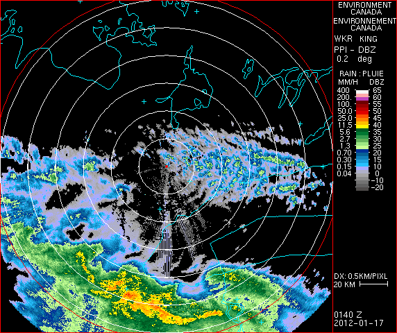
Federal
GPM GROUND VALIDATION ENVIRONMENT CANADA (EC) PASSIVE MICROWAVE RADIOMETER AND SOIL MOISTURE-TEMPERATURE DATA GCPEX V1
National Aeronautics and Space Administration —
The GPM Ground Validation Environment Canada (EC) Passive Microwave Radiometer and Soil Moisture-Temperature Data GCPEx dataset is consisted of data during the GPM... -
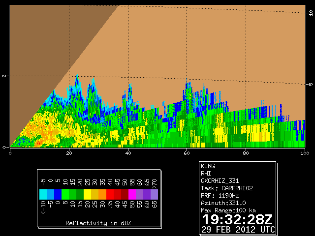
Federal
GPM GROUND VALIDATION DUAL POLARIZED C-BAND DOPPLER RADAR KING CITY GCPEX V1
National Aeronautics and Space Administration —
The GPM Ground Validation Dual Polarized C-Band Doppler Radar King City GCPEx dataset has special Range Height Indicator (RHI) and sector scans of several dual... -
Federal
Charles M. Russell National Wildlife Refuge Fire History GIS Feature Classes
Department of the Interior —
Summary This feature class documents the fire history on CMR from 1964 - present. This is 1 of 2 feature classes, a polygon and a point. This data has a variety of... -
Federal
UARS Microwave Limb Sounder (MLS) Level 3AT V005 (UARML3AT) at GES DISC
National Aeronautics and Space Administration —
The Microwave Limb Sounder (MLS) Level 3AT data product consists of daily, 4 degree increment latitude-ordered vertical profiles of temperature, geopotential height,... -
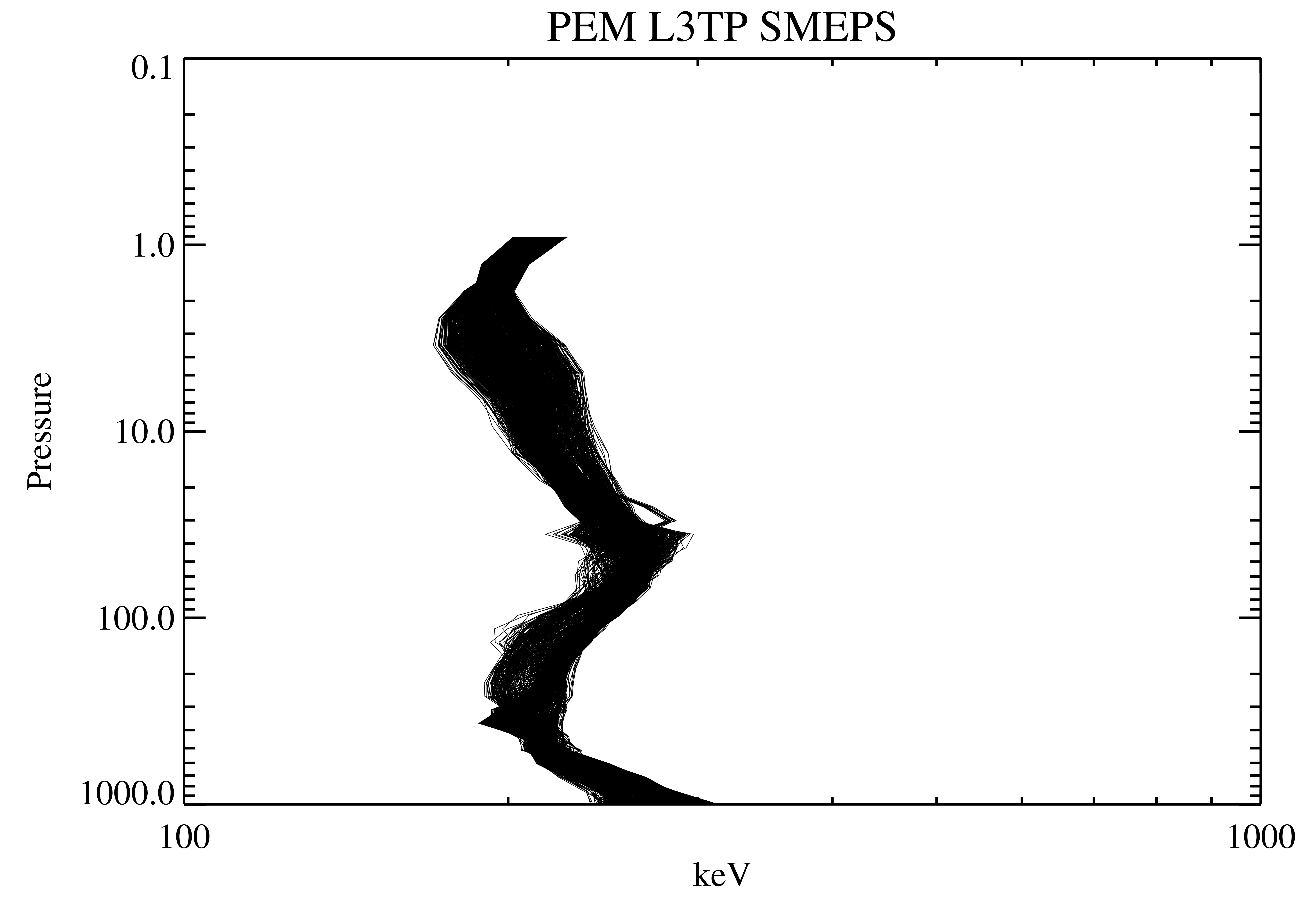
Federal
UARS Particle Environment Monitor (PEM) Level 3TP V004 (UARPE3TP) at GES DISC
National Aeronautics and Space Administration —
The Particle Environment Monitor (PEM) Level 3TP data product consists of daily, 65.536 second and 2.048 interval time-ordered, vertical profiles of electron and... -
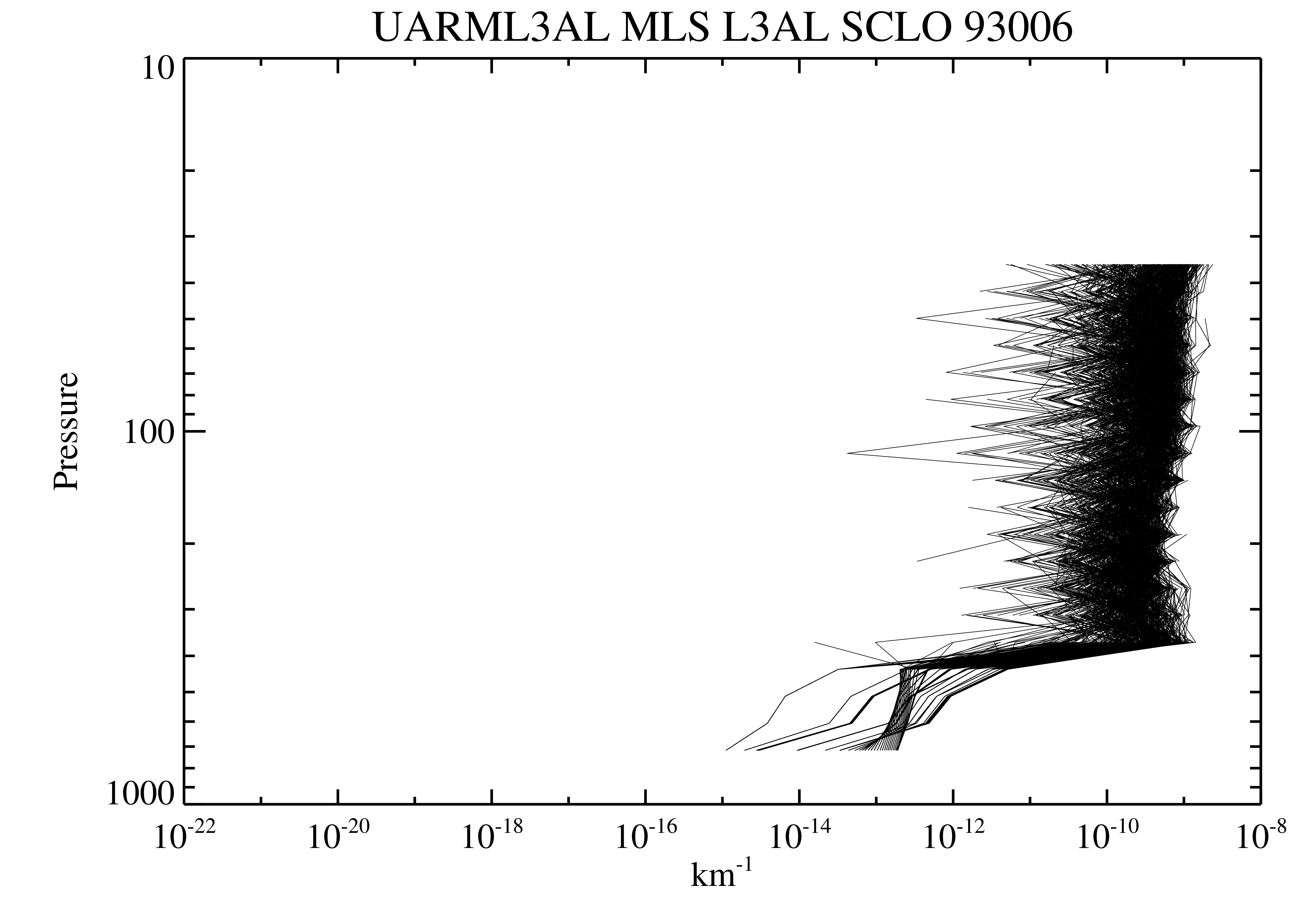
Federal
UARS Microwave Limb Sounder (MLS) Level 3AL V005 (UARML3AL) at GES DISC
National Aeronautics and Space Administration —
The Microwave Limb Sounder (MLS) Level 3AL data product consists of daily, 4 degree increment latitude-ordered vertical profiles of temperature, geopotential height,...

Official websites use .gov
A
.gov website belongs to an official government
organization in the United States.
Secure .gov websites use HTTPS
A
lock (
) or https:// means you’ve safely connected to
the .gov website. Share sensitive information only on official,
secure websites.