
-
Federal
ALOS_PALSAR_RTC_HIGH_RES
National Aeronautics and Space Administration —
PALSAR_Radiometric_Terrain_Corrected_high_res -
Federal
SWOT Level 2 KaRIn Low Rate Sea Surface Height Data Product - Unsmoothed, Version 2.0
National Aeronautics and Space Administration —
The SWOT Level 2 KaRIn Low Rate Sea Surface Height Unsmoothed Data Product from the Surface Water Ocean Topography (SWOT) mission provides global sea surface height... -
Federal
RADARSAT-1_LEVEL1
National Aeronautics and Space Administration —
RADARSAT-1 Level 1 Amplitude Images -
Federal
MetOp-C ASCAT Level 2 Ocean Surface Wind Vectors Optimized for Coastal Ocean
National Aeronautics and Space Administration —
This dataset contains operational near-real-time Level 2 coastal ocean surface wind vector retrievals from the Advanced Scatterometer (ASCAT) on MetOp-C at 12.5 km... -
Federal
SWOT Level 2 KaRIn Low Rate Sea Surface Height Data Product - WindWave, Version 2.0
National Aeronautics and Space Administration —
The SWOT Level 2 KaRIn Low Rate Sea Surface Height Windwave Data Product from the Surface Water Ocean Topography (SWOT) mission provides global sea surface height and... -
Federal
S-MODE Saildrone Level 1 Observations
National Aeronautics and Space Administration —
This dataset contains a suite of Saildrone in-situ measurements (including but not limited to temperature, salinity, currents, biochemistry, and meteorology) taken... -
Federal
SWOT Level 2 KaRIn Low Rate Sea Surface Height Data Product - Basic, Version 2.0
National Aeronautics and Space Administration —
The SWOT Level 2 KaRIn Low Rate Sea Surface Height Basic Data Product from the Surface Water Ocean Topography (SWOT) mission provides global sea surface height and... -
Federal
Automated Surface Observing System (ASOS) IMPACTS V1
National Aeronautics and Space Administration —
The Automated Surface Observing Systems (ASOS) IMPACTS dataset consists of a variety of ground-based observations during the Investigation of Microphysics and... -
Federal
Advanced Vertical Atmospheric Profiling System Dropsondes (AVAPS) IMPACTS V1
National Aeronautics and Space Administration —
The Advanced Vertical Atmospheric Profiling System (AVAPS) IMPACTS dataset consists of vertical atmospheric profile measurements collected by the Advanced Vertical... -
Federal
SWOT Level 2 Nadir Altimeter Geophysical Data Record with Waveforms - SGDR
National Aeronautics and Space Administration —
The SWOT Level 2 Nadir Altimeter Geophysical Data Record (GDR) with Waveforms dataset produced by the Surface Water and Ocean Topography (SWOT) mission provides sea... -
Federal
DC-8 Meteorological and Navigation Data CPEX-AW V1
National Aeronautics and Space Administration —
The DC-8 Meteorological and Navigation Data CPEX-AW dataset is a subset of airborne measurements that include GPS positioning and trajectory data, aircraft... -
Federal
TROPICS01 L2B Deep Multispectral INtensity (DMIN) of Tropical Cyclones Estimator Algorithm V1.0
National Aeronautics and Space Administration —
The "Time-Resolved Observations of Precipitation structure and storm Intensity with a Constellation of Smallsats" (TROPICS) mission has a goal of providing nearly... -
Federal
SWOT Level 2 Radiometer Brightness Temperatures and Troposphere Interim Data Product Version 1.0
National Aeronautics and Space Administration —
The SWOT Level 2 Radiometer Brightness Temperatures and Troposphere Interim Geophysical Data Record (IGDR) Version 1.0 dataset produced by the Surface Water and Ocean... -
Federal
MetOp-A ASCAT Level 2 Ocean Surface Wind Vectors Optimized for Coastal Ocean
National Aeronautics and Space Administration —
This dataset contains operational near-real-time Level 2 coastal ocean surface wind vector retrievals from the Advanced Scatterometer (ASCAT) on MetOp-A at 12.5 km... -
Federal
AMSR-E/AMSR2 Unified L2B Global Swath Ocean Products V001
National Aeronautics and Space Administration —
This AMSR Unified global ocean data set reports integrated water vapor and cloud liquid water content in the atmospheric column, plus 10-meter sea surface wind... -
Federal
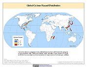
Global Cyclone Hazard Frequency and Distribution
National Aeronautics and Space Administration —
The Global Cyclone Hazard Frequency and Distribution is a 2.5 minute grid based on more than 1,600 storm tracks for the period 1 January 1980 through 31 December 2000... -
Federal
AIRSAR_TOPSAR_P-BAND_STOKES
National Aeronautics and Space Administration —
AIRSAR topographic SAR digital elevation model P_Stokes product

Official websites use .gov
A
.gov website belongs to an official government
organization in the United States.
Secure .gov websites use HTTPS
A
lock (
) or https:// means you’ve safely connected to
the .gov website. Share sensitive information only on official,
secure websites.