
-
Federal
Daily and Annual PM2.5, O3, and NO2 Concentrations at ZIP Codes for the Contiguous U.S., 2000-2016, v1.0
National Aeronautics and Space Administration —
The Daily and Annual PM2.5, O3, and NO2 Concentrations at ZIP Codes for the Contiguous U.S., 2000-2016, v1.0 data set contains daily and annual concentration... -
Federal
2018 Environmental Performance Index (EPI)
National Aeronautics and Space Administration —
The 2018 Environmental Performance Index (EPI) ranks 180 countries on 24 performance indicators in the following 10 issue categories: air quality, water and... -
Federal
OMI/Aura Ozone (O3) Total Column 1-Orbit L2 Swath 13x24 km V003 NRT
National Aeronautics and Space Administration —
The OMI/Aura Level-2 Total Column Ozone Data Product OMTO3 Near Real Time data is made available from the OMI SIPS NASA for the public access. The Ozone Monitoring... -
Federal
2008 Environmental Performance Index (EPI)
National Aeronautics and Space Administration —
The 2008 Environmental Performance Index (EPI) centers on two broad environmental protection objectives: (1) reducing environmental stresses on human health, and (2)... -
Federal
OMI/Aura Sulphur Dioxide (SO2) Total Column 1-orbit L2 Swath 13x24 km V003 NRT
National Aeronautics and Space Administration —
The Ozone Monitoring Instrument (OMI) was launched aboard the EOS-Aura satellite on July 15, 2004 (1:38 pm equator crossing time, ascending mode). OMI with its 2600... -
Federal
Nimbus-7 Total Solar Irradiance Data in Native Format
National Aeronautics and Space Administration —
The NIMBUS7_ERB_Ch10C_TSI_NAT data set is the Nimbus-7 Channel 10C (Ch10C) Total Solar Irradiance (TSI) aboard the Earth Radiation Budget (ERB) satellite Data in... -
Federal
2012 Environmental Performance Index and Pilot Trend Environmental Performance Index
National Aeronautics and Space Administration —
The 2012 Environmental Performance Index (EPI) ranks 132 countries on 22 performance indicators in the following 10 policy categories: environmental burden of... -
Federal
SASS (Subsonics Assessment) Ozone and NOx Experiment (SONEX) DC-8 In-Situ Meteorological and Navigation Data
National Aeronautics and Space Administration —
SONEX_TraceGas_AircraftInSitu_DC8_Data_1 is the in-situ meteorological and navigation data collected onboard the DC-8 aircraft during the SASS (Subsonics Assessment)... -
Federal
Nimbus-7 Solar and Earth Flux Data in Native Binary Format
National Aeronautics and Space Administration —
The NIMBUS7_ERB_SEFDT data set is the Solar and Earth Flux Data Tape (SEFDT) generated from Nimbus-7 Earth Radiation Budget (ERB) instrument data. The main purpose of... -
Federal
OMI/Aura Near UV Aerosol Optical Depth and Single Scattering Albedo 1-orbit L2 Swath 13x24 km V003 NRT
National Aeronautics and Space Administration —
The OMI/Aura level-2 near UV Aerosol data product 'OMAERUV', recently re-processed using an enhanced algorithm, is now released (April 2012) to the public. The data... -
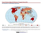
Federal
Country Trends in Major Air Pollutants
National Aeronautics and Space Administration —
The Country Trends in Major Air Pollutants data set is a framework of public-health-focused air quality indicators that quantifies over 200 countries' trends in... -
Federal
OMI/Aura Cloud Pressure and Fraction (Raman Scattering) 1-Orbit L2 Swath 13x24 km V003 NRT
National Aeronautics and Space Administration —
The reprocessed Aura OMI Version 003 Level 2 Cloud Data Product OMCLDRR is made available (in April 2012) to the public from the NASA Goddard Earth Sciences Data and... -
Federal
Nimbus-7 Narrow Field of View (NFOV) Maximum Likelihood Cloud Estimation (MLCE) Data in Native Format
National Aeronautics and Space Administration —
NIMBUS7_NFOV_MLCE data are Nimbus 7 Narrow Field of View (NFOV) Maximum Likelihood Cloud Estimation (MLCE) Data in Native Format.The NIMBUS7_NFOV_MLCE data set uses... -
Federal
TES/Aura L2 Ozone Nadir V007
National Aeronautics and Space Administration —
TL2O3N_7 is the Tropospheric Emission Spectrometer (TES)/Aura Level 2 Ozone Nadir Version 7 data product. It consists of information for one molecular species for an... -
Federal
TES/Aura L2 Methane Nadir V007
National Aeronautics and Space Administration —
TL2CH4N_7 is the Tropospheric Emission Spectrometer (TES)/Aura Level 2 Methane Nadir Version 7 data product. TES was an instrument aboard NASA's Aura satellite and... -
Federal
GPM Ground Validation Physicum Building Mast Meteorological Data LPVEx V1
National Aeronautics and Space Administration —
The GPM Ground Validation Physicum Building Mast Meteorological Data LPVEx dataset consists of meteorological data (temperature, pressure, wind, precipitation, and... -
Federal
MISR Motor Data V003
National Aeronautics and Space Administration —
MISR Level 1A Motor Data are acquired as part of an on-orbit calibration experiment. These data consist of measurements of the MISR instrument calibration panel motor... -
Federal
TES/Aura L2 Methanol Nadir V007
National Aeronautics and Space Administration —
TL2MTLN_7 is the Tropospheric Emission Spectrometer (TES)/Aura Level 2 Methanol Nadir Version 7 data product. TES was an instrument aboard NASA's Aura satellite and...

Official websites use .gov
A
.gov website belongs to an official government
organization in the United States.
Secure .gov websites use HTTPS
A
lock (
) or https:// means you’ve safely connected to
the .gov website. Share sensitive information only on official,
secure websites.